|
The North Atlantic Gyre
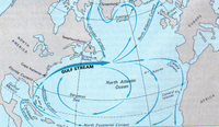
The waters that feed the Gulf Stream begin flowing off the west coast of Northern Africa. Under the influence of the Trade Winds, the North Equatorial Current drifts towards the Caribbean Sea. The current narrows as it flows through the Caribbean islands and the Yucatan Channel, gathering strength as it compresses through this area. When it circulates through the Gulf of Mexico’s warm waters, the Gulf Stream becomes visible in satellite images, as a warm and intense oceanic current that continues its flow through the Straits of Florida. It then gains even more strength as it joins the Antilles Current, becoming a powerful underwater current that continues flowing parallel to the east coast of the United States, and finally into the open Atlantic ocean, in a northeastern direction.
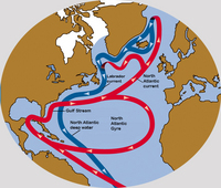
While flowing in this deeper ocean water, the Gulf Stream forms large meanders, and splits into several currents, the largest of which is the North Atlantic Current.
Ocean currents are driven by a combination of the Earth’s rotation, wind, and differences in temperature and salt concentration in the water (known as ‘thermohaline gradients’). The Gulf Stream is mainly driven by wind, whereas the North Atlantic Current is thermohaline -driven. Wind-generated currents are the result of friction between the water surface and the overlying atmosphere. When the wind blows over the surface, it drags water along with it, causing a fast flowing current that gradually decreases its speed with depth. The combination of the Trade Winds blowing to the West and the Westerlies Winds blowing to the East cause the North Atlantic to rotate clockwise. However, some currents that split from the Gulf Stream do not follow this path. Instead, they flow towards the North. On its way to the North, the warm water evaporates, which causes the salt content to increase and the average temperature to decrease. Consequently the sea water becomes more and more dense, and the water starts to sink as it reaches higher latitudes. The cold, northern currents then flow in a rotating current system called the North Atlantic subpolar gyre, of which the Labrador Current is the southward flowing component. This cold current meets the Gulf Stream at the Grand Banks southeast of Newfoundland, after which it starts flowing parallel and in an opposite direction to the Gulf Stream. Further on, this cold, dense current continues its path towards the South, crossing underneath the warm surface of the Gulf Stream.
This continuous water movement in the North Atlantic is part of the global-scale thermohaline circulation, also referred to as The Great Ocean Conveyer Belt.
A dynamic current Oceans also have their seasons. They derive from changes in atmospheric conditions such as winds and temperature. Since the sea surface is in direct contact with the atmosphere, its temperature follows atmospheric seasonal patterns. However, water has a specifically high heat capacity and therefore it takes a lot of time to change its temperature. It takes an even longer time when it is an immense body of water such as an ocean. Taking into consideration not only the surface, but all of the water column, oceanic seasons are shifted two months with respect to their atmospheric equivalents. Depending on the season, the water column expands when the weather is warm, and contracts when it is cold. The water dilatation and contraction due to the change in temperature makes the sea surface height fluctuate. The surface height can undergo a variation of around 10 to 15 centimetres between spring, after losing heat during the winter, and autumn, after gaining heat during the summer. In addition, the current not only varies in height, but also experiences spatial changes. The position of the Gulf Stream as it leaves the coast beyond Cape Hatteras changes slightly throughout the year. The Gulf Stream is located at approximately 37°N. In autumn it shifts further north, while in spring it moves slightly to the south.
With appropriate time series data, other variable characteristics of the Gulf Stream can be observed and analysed, such as changes in water transport, structure and meandering.
Last update: 24 June 2013
| ||||||||||||||||||||||||||||||||||||||||||||||||||||||||