|
Background
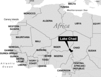
These lake-feeding rivers are subject to considerable annual fluctuations with respect to their water level. The water balance of Lake Chad is therefore dependent on the drainage basin of the Chari and Logone Rivers, which is located approximately 800 kilometres away. The water level of the lake alternates to the rhythm of the rainy seasons, and can either cause floods over kilometres of flat land, or shrink to occupy a smaller area. The flooded areas, that can extend to 8000 square kilometres, are being used by both fishermen and farmers. The latter use them to cultivate wet rice. Lake Chad’s surface was conspicuously reduced in the 1960’s, when the quantity of water carried by the Chari River decreased by more than 50 per cent. The decrease took alarming proportions during the droughts of the 1970’s. The Northern lake basin ran totally dry, and only a small expanse of water remained in the South. Nigeria completely lost access to the open water surface.
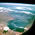
Presently Lake Chad’s water level stands at about 240 metres above mean sea level, and covers approximately 12,000 to more than 20,000 square kilometres (depending on whether it is a dry or rainy season). The depth fluctuates depending on the season.
A deep wetland The Lake Chad bed is flat and shallow – only 10.5 metres at its deepest. This particularity makes it very sensitive to small changes in depth. Even before it started shrinking, Lake Chad was not very much deeper than it is now. For this reason, it may be more appropriate to refer to it as a ‘deep wetland’ rather than a lake.
If we refer to it as a wetland, Lake Chad was once the second largest wetland in Africa. It was very productive and supported a variety of wildlife. Lake Chad is subject to seasonal fluctuations in the order of about 1 metre every year .
Because it is flat and shallow, Lake Chad is very responsive to changes in rainfall. Annual rainfall ranging between 125 and 565 mm was measured between 1954 and 1972. So when rainfall is low, as in 1972, the water levels drop very quickly. This is because, on average, rainfall makes up between 20 and 80% of Lake Chad’s volume every year.
Due to the soil properties of the Chari basin, water runs off as sheetwash rather than slow percolation. There is of course a certain delay between upstream rainfall and the associated rise in Lake Chad’s water level. Most of the rainfall occurs between June and September. However, an abrupt and rapid rise in the lake water level can be observed during the month of November. Consequently, water levels peak in December and gradually decrease during the following months.
Last update: 19 November 2013
| ||||||||||||||||||||||||||||||||||||||||||||||||||||||||||