|
Iqaluit, Canada
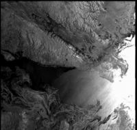
This image was taken by Envisat's radar ASAR at an altitude of 700 km. It covers a 400 × 400 km area showing the southern tip of Baffin Island, the large southernmost island between Canada and Greenland.
The image was taken on the afternoon of 21 December 2003 with very little sunlight. Nevertheless we can see all details of the land and the ice. Indeed, this is a radar image, and the radar does not need the Sun's illumination. It works with its own source of energy and sends out and receives bursts of microwaves which are subsequently processed onto an image. a larger version of the Iqaluit image and its surroundings (0.8 Mb). The landscape shows the characteristices of very old rocks that have been deformed and then shaped by huge glaciers during the last Ice Age. On the sea, different ice formations can be observed. The bright area and many grey patches are either open water or thin ice floes moving up and down in the high swell, moved by strong easterly winds. The bright spots near the right edge are icebergs. The dark patches represent thick ice, and are found either drifting far out in the sea, or attached to the land. They make the access to the inhabited areas difficult when icebreakers need to reach the shore. On the southern peninsula, two greyish white areas are visible. These are two small plateau glaciers.
Can you distinguish Iqaluit on the image?
Look for an accumulation of bright points in the inner part of Frobisher Bay, between the two Peninsulae. Could one reach it by ship in December 2003 without an accompanying icebreaker? Near the bottom of the image, three parts of land are visible. To which province(s) of Canada do they belong? And what about the piece of land in the middle?
Use an atlas to find the answer, or consult www.city.iqaluit.nu.ca
Last update: 3 July 2013
| ||||||||||||||||||||||||||||||||||||||||||||||||||||||