Short introduction to the weather in Europe


An aerial view of Svalbard


The weather in Europe is dominated by several factors.

North to South

In the winter you will mostly find a temperature gradient from north to south. Sometimes well-defined zones divide Europe into two halves, with cold weather in the north and warmer weather in the south.
 
 
High going sea
   
High going sea
 
East to West
 
Western Europe is periodically affected by air brought onshore by Atlantic Ocean currents. In the winter, this often means that the further west you go, the warmer it becomes. However, during the summer, the further east (away from the sea) you go, the higher the temperature, as the land warms up more than the sea.
 
 
Cyclone Gamede


Cyclones
 
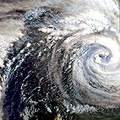
The convection zone marks the boundary between warmer and colder air masses. The location of the convection zone is important because it determines the path followed by low pressure systems and their corresponding warm and cold fronts. In the winter the path is located to the south of the Mediterranean, whereas in the summer the convection zone is moved more to the north by jet streams. The cyclones bring wind and precipitation.
 
 
Extreme weather
 
Europe sometimes experiences extreme weather. This includes heavy storms and heavy rain with flooding.


Last update: 17 April 2013


Interactive Meteosat

 •  Introduction (http://www.esa.int/SPECIALS/Eduspace_Weather_EN/SEM1AAKTYRF_0.html)
 •  Meteosat images (http://www.esa.int/SPECIALS/Eduspace_Weather_EN/SEMFDAKTYRF_0.html)
 •  Weather observations (http://www.esa.int/SPECIALS/Eduspace_Weather_EN/SEMGFAKTYRF_0.html)
 •  Wind (http://www.esa.int/SPECIALS/Eduspace_Weather_EN/SEMYHAKTYRF_0.html)
 •  Cloudiness (http://www.esa.int/SPECIALS/Eduspace_Weather_EN/SEMBKAKTYRF_0.html)
 •  Temperature (http://www.esa.int/SPECIALS/Eduspace_Weather_EN/SEM7OAKTYRF_0.html)
 •  Upload observations (http://www.esa.int/SPECIALS/Eduspace_Weather_EN/SEMYPAKTYRF_0.html)

Exercises

 •  Introduction and exercises (http://www.esa.int/SPECIALS/Eduspace_Weather_EN/SEMLQAKTYRF_0.html)

Links

 •  Eumetsat (http://www.eumetsat.int)
 •  Sarepta (http://www.sarepta.org/en/index.php)
 •  Dundee Satellite Receiving Station (http://www.sat.dundee.ac.uk/)
 •  WetterZentrale (http://www.wetterzentrale.de/)
 •  US National Hurricane Center (http://www.nhc.noaa.gov/)
 •  NOAA (http://www.noaa.gov/)
 •  Met Office (UK) (http://www.metoffice.gov.uk/)
 •  Weather map
with fronts
(choose
'Bodenanalyse')
(http://www.wetterzentrale.de/)
 •  Historical Data (http://www.eumetsat.int/Home/Main/Image_Gallery/index.htm?l=en)
 •  Cloud atlas (http://www.wolkenatlas.de/)
 •  Current weather (http://www.wetterzentrale.de/)
 •  Map of the frontal zone (http://www.wetterzentrale.de/pics/bracka.html)
 •  Map showing prognosis frontal zone (http://www.ecmwf.int/products/forecasts/d/charts)

Eduspace - Download

 •  Images and observations archive (http://www.eduspace.esa.int/eduspace/meteosat/viewArchive.asp)
 •  Download latest Meteosat animation (http://www.eumetsat.int/Home/Main/Image_Gallery/Real_Time_Imagery/index.htm?I=en)