|
Sea surface currents The major driving force of surface currents is the wind. The winds that drive the Gulf Stream are the Westerlies. They blow in an eastwards direction and penetrate to a depth of approximately 200 metres, dragging the surface water at high velocity over a long distance. Currents and winds are both measured as velocity vectors. Their magnitude is therefore expressed in distance travelled over time, and they move in cardinal directions.
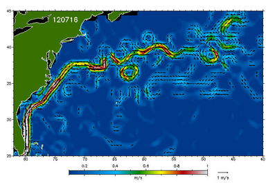
Gulf Stream velocity fields are derived from near-realtime radar altimeter data. An absolute geostrophic velocity map combines both northward and eastward velocity fields to form a significant surface current structure. The velocities of the currents are represented by arrows and/or colour codes. The length of the different arrows show the magnitude of the velocity, by comparing them with the reference 1 m/s arrow drawn next to the colour bar. The direction in which the arrows point is the direction of the current. An arrow pointing to the right would therefore indicate an eastward flow.
In order to observe the influence of winds over surface currents, it is interesting to compare the sea surface velocity fields to wind velocity fields measured by wind scatterometers. Essentially, radar scatterometers operate by transmitting a pulse of microwave radiation towards the surface of study, and measuring the reflected energy. The comparison of both parameters is very useful for climate studies. Last update: 24 June 2013
| ||||||||||||||||||||||||||||||||||||||||||||||||||