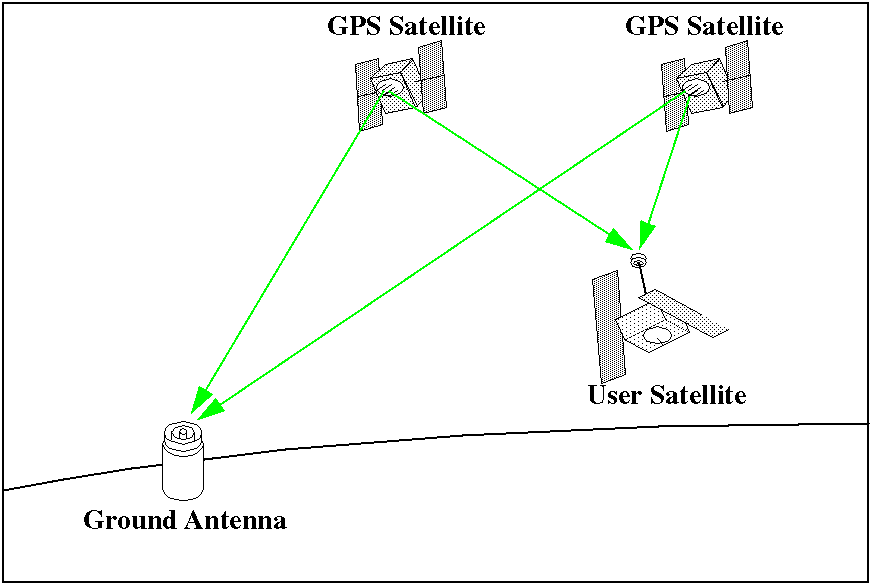
Figure 1. Common observability of GPS satellites by ground and onboard receivers allows a better determination of the satellite orbit.

The Global Positioning System (GPS) is currently being used for a wide variety of applications. A GPS receiver aboard a spacecraft can provide the means for autonomous navigation and also allows a very accurate reconstitution of the trajectory of the spacecraft when onboard recorded measurements are combined with ground-based measurements.
This article outlines some of the basic concepts involved and presents the activities that the European Space Operations Centre is carrying out in the field of satellite navigation using GPS.
The launch of the first Sputnik triggered the initial challenge in satellite navigation: the determination of the characteristics of the orbit of the satellite, using the variations in the signal that was being radiated by the satellite. Within a short time the idea of using the inverse process was developed: if, by knowing your position you could determine the orbit of a satellite, then it should also be possible to use the signal transmitted by a satellite in a known orbit, in order to determine your own position. This concept was implemented in a series of satellites sponsored and operated by the US Armed Forces. Firstly, the Transit satellites were deployed, then the Timation and finally, the NAVSTAR GPS system.
The focus of these programs was to provide the military forces of the US and its allies with precise positioning capabilities. In response the Soviet Union also developed and deployed similar Global Navigation Satellite Systems (GNSS): Tsikada and GLONASS.
From the very beginning it was realised that these systems could also be used for a wide range of scientific and other civil applications. New tracking methods that were not foreseen by the original developers of the systems, like carrier tracking, were proposed and, as soon as it was possible, successfully tested and used.
One of the applications that was soon envisioned was the use of GPS for navigation of spacecraft. The first onboard receiver was installed and flown in a Landsat satellite even before the complete GPS constellation was deployed. Since that time, more receivers have been flown on satellites, at first as a demonstration of increasingly precise uses and now as the main operational means of navigation.
The NAVSTAR Global Positioning System, usually called GPS, consists of three components: a space segment of GPS satellites, a control segment that monitors and operates those satellites and a user segment that employs GPS receivers to observe and record transmissions from the satellites and perform position, velocity, attitude and time calculations.
The GPS space segment
The space segment is based on three-axis stabilised satellites orbiting
in near-circular orbits with a period of half a sidereal day and an inclination
of 55 degrees. There are six orbital planes, each with four satellites.
This constellation provides global coverage with more than four satellites
in view at all times.
The significance of the visibility of at least four satellites is that the GPS system is intended to allow instantaneous real time determination of the user position (3 variables) and the time of the fix (one more variable). Previous positioning systems, like the methods used in the Transit and Tsikada systems, were based on the processing of several passes of data (requiring hours to days) and did not provide the instantaneous solutions that GPS (or GLONASS) offers.
The GPS satellites carry very stable atomic clocks that are used to derive the ranging signals. The basic signal for civil use, L1, has a frequency of 1575.42 MHz and it is modulated with a Clear Acquisition (C/A) Pseudo Random Noise (PRN) code at 1.023 MHz that is different for every satellite. The signal is also modulated with a 10.23 MHz Precise (P) code that is usually encrypted and only available to authorised users. Additionally, there is a 50-bit-per-second modulation which is used to transmit the satellite ephemerides (predicted orbit and clock) and other information. Authorised users also have access to the Precise code on a second frequency, L2, which allows users to correct for ionospheric propagation delays. Some receivers are able to measure the delay between the signal in the L1 frequency and the L2 frequency without access to the P code. There are plans to add, in future satellites, another frequency for civil users so they can easily correct for ionospheric delays.
The GPS control segment
The GPS control segment tracks and monitors the signal from the GPS space
segment and estimates the orbits and clock behaviour of the satellites.
This information is uploaded to the satellites so it can be transmitted
to users.
The GPS user segment
The GPS user segment can perform two basic measurements of the GPS signals.
The first method compares the C/A or P code that it is receiving with a
locally generated copy in order to compute the transmission delay between
the satellite and the receiver. This measurement is called pseudo-range.
Pseudo-ranges to four or more satellites can be used to determine the position
of the user once the position of the GPS satellites has been obtained using
the ephemerides of the navigation message.
The second and more precise method is to obtain the difference in phase between the received carrier signal and a receiver-generated signal at the same frequency. This measurement is known as the carrier phase observable and it can reach millimetre precision. However, it lacks the accuracy of the pseudo-range because once the tracking is started, the phase can only be identified with an ambiguity of an unknown number of times the carrier wavelength (about 19 cm for L1).
Figure 1. Common observability of GPS satellites by ground and onboard
receivers allows a better determination of the satellite orbit.
The number of applications and users of the GPS system has exploded in the last years, well beyond any expectations. The latest receivers are inexpensive, small, offer very good performance and are easy to use.
One of the first scientific applications of GPS was to precisely determine the position of fixed ground antennas in order to study the dynamics of the Earth surface. It was soon realised that in order to obtain the best results it would be necessary to compute very precise orbits of the GPS satellites. A number of groups started doing this and, as a result, the first orbits that were precisely obtained using GPS were those of the GPS satellites themselves.
GPS has many advantages for the tracking of satellites orbiting the Earth. It provides unsurpassed observability because low-Earth satellites are able to track six or more GPS satellites, with tracking arcs amounting to about half of the user satellite orbit. This cannot be achieved by any ground-based tracking station. This ability also renders the method robust. There is a high level of redundancy because orbits can be determined with as few as two GPS satellites being tracked at any time. When four satellites are being tracked, GPS allows for real-time autonomous determination of the position of the satellite, with an accuracy equivalent to that obtained with non-precise ground tracking methods. If a precise dual-frequency receiver is used and data is processed together with ground based data, GPS possibly provides the best accuracy that can be achieved in precise orbit determination.
The first user satellite to fly a precise GPS receiver was the TOPEX/Poseidon altimeter satellite. Since then, other satellites have been flown with different types of receivers. Table 1 details the different applications for a GPS receiver aboard a spacecraft.
Current uses:
Future uses:
ESA has been involved in GPS activities since the late eighties with the development of space qualified GPS and GPS/GLONASS receivers, the ESOC activities which support spacecraft navigation and, recently, within the ARTES program, the European Geostationary Navigation Overlay Service (EGNOS). EGNOS will complement the GPS system in order to provide European users with increased availability, integrity and accuracy for real-time applications such as aircraft navigation.
It is foreseen that ESA will participate in the development of future Global Navigation Satellite Systems (GNSS) that may replace GPS, GLONASS and their augmentations for such purposes in the future.
GPS has been proposed as the tracking or scientific instrument for several ESA spacecraft. It is the main positioning instrument envisioned for the Automated Transfer Vehicle (AT), both for absolute navigation and for navigation relative to the International Space Station. The ATV Rendezvous Pre- development (ARP) program is being carried out to validate methods for relative navigation that will be used for ATV, including relative GPS navigation. Other spacecraft for which a GPS receiver has been proposed include several of the Earth Explorer candidates and other future observation and scientific satellites (Metop, STEP).
Within the European Space Agency, ESOC is responsible for the operation of ESA spacecraft. This includes the flight dynamics activities needed to achieve and maintain their desired orbit and attitude. In order to fulfil this task, ESOC began to prepare itself to support ESA missions that might use the GPS system as soon as GPS was proposed for spacecraft navigation.
ESOC had an excellent opportunity to do so by contributing to the success of the International GPS Service for Geodynamics (IGS). Scientists were proposing to install a permanent network of precise ground-based GPS receivers that would allow the monitoring of the movement of the Earth's surface in order to better understand plate tectonics and local deformations that are the cause of earthquakes. The data from these receivers could be processed in order to obtain precise orbits for the GPS satellites that would be used by geodesists in regional deformation studies. Additionally within the IGS Terms of Reference was a provision of support for other applications, including scientific satellite orbit determination. The assets which ESOC could contribute to the IGS were its network of ground stations in which receivers could be installed and its expertise, supported by in-house developed software, in precise orbit and geodetic parameter estimation.
The first receiver was installed in Maspalomas (Spain) in June 1992 (Fig. 2). Receivers have also been installed in Kourou (French Guyana) in July 1992, Kiruna (Sweden) in July 1993, Perth (Australia) in August 1993, Villafranca (Spain) in November 1994 and Malindi (Kenya) in November 1995. Precise estimation software was extended to include GPS measurement types for both ground-based and spacecraft-borne receivers. We have been providing data and increasingly precise GPS products for the last five years. Currently we provide:

Figure 2. Pillar-mounted GPS antenna and pillar in Maspalomas, Spain.
ESOC is currently an active IGS Analysis and Operational Data Centre and is especially involved in discussions to extend the IGS to use space-borne receivers.
The ESA GPS Tracking and Data Analysis Facility (GPS TDAF) has been developed in order to support the GPS activities carried out by ESOC. It includes a network of ground GPS receivers, the necessary communication interfaces to allow the remote operation and data downloading from ESOC, and the processing and analysis software needed to format the data and to obtain the precise products (Fig. 3). The system is highly automated, and includes an easy to operate interface for the retrieval and the processing of the data (Fig. 4). The GPS-TDAF is currently being extended to process GLONASS data and to include real-time monitoring capabilities that may be needed to support critical operational phases like rendez- vous.
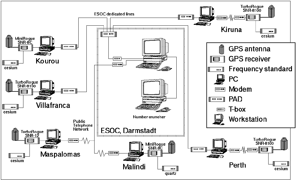
Figure 3 : Current configuration of the GPS-TDAF.
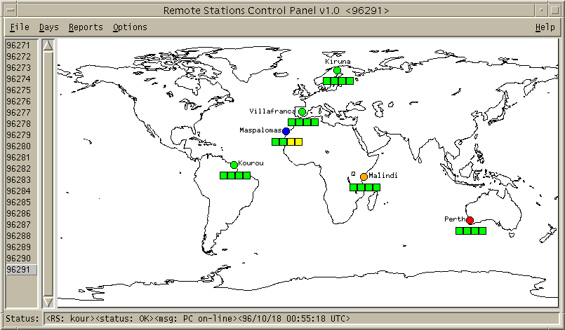
Figure 4. Remote Station Control panel of the GPS-TDAF. This panel is used to monitor the daily retrieval tasks.
Other recent developments are:
The driving reason for implementing a GPS-TDAF in ESOC was to provide ESA with the capability to support the navigation of satellites equipped with GPS receivers. This support involves the following activities:
Support of critical real-time GPS applications
GPS has been proposed as the absolute and relative positioning system for
spacecraft going to the manned International Space Station. For this application
it is clear that the ground segment cannot be in-the-loop for the calculation
of real-time trajectories of the spacecraft involved because of the unavoidable
delays that this will create. Still, the ground segment has a role in monitoring
the integrity of the signals that are to be used for critical operations.
This can be accomplished using a ground network of GPS receivers that is able to track all the satellites that the orbiting spacecraft may use. The navigation data and observations of these precisely located ground stations can be processed in order to check their integrity and to estimate the error in the signal for each GPS satellite. Poorly performing satellites can be identified and the number of healthy GPS satellites observable by the user spacecraft during the critical operations can be predicted. This can also be done in real-time in order to detect satellite failures that can affect the navigation solution of the user spacecraft, so that the information can be delivered to Mission Control and the poor performing GPS satellites can be excluded from the onboard computed navigation solution.
Another role of the ground segment will be to support the validation of the receivers and their correct functioning before critical operations are started. It can also assist in the fast re-start of receivers by providing up-to-date almanacs and other initialisation data.
ESOC has installed GPS receivers at six ground stations and it is developing a real-time communication system that will allow for the continuous monitoring of the GPS spacecraft visible from these ground receivers.
Precise orbit determination using GPS
GPS is one of the best tracking types for Precise Orbit Determination of
Low Earth Orbit satellites because it combines high accuracy with unsurpassed
observability. The high accuracy is obtained by using the GPS carrier phase
observable, free of ionospheric errors, when dual frequency data is used.
The observability is provided by the high number of GPS satellites that
can be simultaneously tracked by an orbiting receiver.
ESOC has incorporated models for the most widely used GPS measurements in its Precise Orbit Determination software. This has been done both for the determination of the orbit of the GPS spacecraft and for the determination of the orbit of user spacecraft (spacecraft carrying a GPS receiver). The implementation has been validated using TOPEX/Poseidon data and the software is currently being used to support the ARP Flight Demonstrations. More information on these activities is given below.
Determination of the orbits and clocks of the GPS satellites
For some applications it is not necessary to simultaneously solve for the
orbits of the GPS spacecraft and the user spacecraft. The orbits and clock
biases of the GPS spacecraft can be precisely computed and then held fixed
for the computation of the orbit of the user spacecraft.
ESOC has been participating in the International GPS Service for Geodynamics (IGS) since its establishment, and producing precise orbit and clocks solutions for the GPS satellites. These ephemerides are estimated to be accurate to about 10 cm.
Our GPS orbit determination software is also being used for feasibility and validation experiments for the ARTES-9 EGNOS project.
Operational orbit determination using GPS
The facilities implemented for Precise Orbit Determination can also be
used for Operational Orbit Determination to produce a very accurate orbit
prediction and to calibrate manoeuvres. This on-ground determined orbit
can also be used during the spacecraft check-out to assess GPS-based onboard
orbit determination.
For some applications it is not necessary to be able to produce a precise orbit prediction. In these cases the GPS- based onboard generated positions can be used on the ground as observable in order to determine the orbit that will be used for orbit control, mission planning and station visibility predictions. This process can also assess the quality of the onboard generated positions.
In this context, our GPS orbit determination software will be used operationally to determine the orbit of the Danish ørsted geomagnetic research microsatellite.
Geophysical parameter estimation
Most of the activities listed previously are possible because networks
of precise geodetic receivers are currently deployed to support these and
other applications. For the most accurate applications, the position of
the receivers in these networks has to be precisely determined, together
with a number of other geophysical parameters. The accurate determination
of the position of the ESA ground stations, the determination of Earth
orientation parameters and the calculation of ionospheric calibrations
can also support other projects that are not directly using GPS but need
an accurate location of the position of tracking antennas and correction
for ionospheric delays.
ESOC is contributing to the estimation of very precise station coordinate solutions that include the ESA ground stations, and through the IGS, also to the activities of the International Earth Rotation Service (IERS). We are currently testing the use of GPS derived ionospheric models in order to correct one-frequency ERS altimeter measurements and the S-band ranging and doppler measurements used for the routine control of most spacecraft.
TOPEX/Poseidon (T/P) is a joint US/French altimetric spacecraft launched in August 1992. The main scientific goal of this mission is to produce sea level maps to study ocean circulation and variability. Accurate orbit determination is vital to the success of this or any other altimetric missions. In this case, the fundamental quantity measured is the geocentric height of the sea surface, and obtained as the difference between the radial orbit position and the altimeter measurement proper. The orbit determination requirements for T/P were set to a very demanding 13 cm error budget for the radial position. In order to satisfy this challenge an unprecedented effort was made to improve the gravity model of the Earth and, to further guarantee the best possible results in orbit determination, several tracking systems were placed onboard: retroreflectors for Satellite Laser Ranging (SLR), a DORIS receiver, and an experimental precise GPS receiver. Effectively, this has made the T/P spacecraft a veritable orbit determination laboratory that allows intercomparisons between different tracking techniques.
T/P has been of unique importance for the validation of techniques for GPS-based satellite navigation. It is equipped with a high precision dual-frequency GPS receiver producing long cycle-slip free carrier phase passes as well as pseudo- range measurements. It was launched when the GPS constellation was almost complete and when the IGS network of high precision GPS receivers had started to provide continuous globally distributed tracking data.
For our evaluation, a 10-day period was selected for the comparison of the orbit restitution capabilities of the three techniques: SLR, DORIS and GPS. For the GPS processing, T/P observations were used together with data from about 20 ground receivers from the IGS network. The orbit of the T/P spacecraft was then solved simultaneously with the orbits of the GPS spacecraft. The chosen data type was double-difference phase measurements involving two GPS satellites and two GPS receivers.
Comparisons were made to determine the ephemerides generated using only GPS and using a combination of SLR and DORIS, with external solutions obtained by the Delft University of Technology (DUT) and the Jet Propulsion Laboratory (JPL). The orbits show a remarkable agreement, with the difference in radial direction in the order of 2 cm, and along track and cross track differences in the order of 5 to 10 cm.
These results demonstrate the capability of the GPS-TDAF to produce very accurate results when precise data collected onboard can be combined with on-ground collected data from a network of high precision GPS receivers.
ESA is developing the unmanned Automated Transfer Vehicle (ATV) that will serve as a logistic / re-supply vehicle for the International Space Station (ISS). The ATV will perform a number of manoeuvres in order to rendezvous and dock with the ISS. GPS is baselined as the main positioning system for the ATV. It will be used for autonomous absolute position determination and autonomous relative position determination with respect to the ISS. For autonomous absolute position determination the ATV will be equipped with a one-frequency GPS receiver that will provide position, velocity and time solutions. For autonomous relative position determination the ISS will also be equipped with a GPS receiver that will provide GPS observables for transmission to the ATV. The ATV will process them together with its own GPS observables in order to determine its position and velocity relative to the ISS.
The ATV Rendezvous Pre-development (ARP) project covers the pre-development of rendezvous technologies critical to ATV. One of the aspects that are covered by this project is the validation of relative navigation using GPS observables. For this, three Flight Demonstrations (FD) are planned, in which the Space Shuttle will act as chaser and another spacecraft (Astrospas for FD1 and the MIR station for FD2 and FD3) will be the target. These spacecraft will carry one-frequency GPS receivers and will collect GPS data during the proximity operations. The data will be post-processed on the ground to validate the relative navigation algorithms.
The role of ESOC in these three ARP FDs is to compute reference trajectories (relative and absolute) for the spacecraft involved using all available measurements. These trajectories will be then used to compare with the results of the relative navigation filter. ESOC will obtain the trajectories using the following data:
The data will be decoded and converted to an engineering format that will then be fed to a program which will produce the best estimate trajectories for the spacecraft. This program is called GPSBET (GPS Based Estimator of Trajectories) and it includes the following:
We are currently processing data from the first ARP Flight Demonstration and we expect to achieve absolute positioning results with about 1 metre accuracy and even better relative-positioning accuracy.
The GPS system, originally deployed to allow very precise delivery of weapons, has demonstrated an incredible versatility of use for civil applications. GNSS systems are ideal to support many aspects of the navigation of spacecraft orbiting the Earth. They can support increased spacecraft autonomy and, when used together with ground collected measurements, they provide unsurpassed accuracy. The ESA GPS-TDAF is already supporting validation activities for navigation of spacecraft using GNSS systems and will also be able to support preparations for a European contribution to future Global Navigation Satellite Systems.
Additional information on these activities, as well as links to other related World Wide Web sites, can be found under http://nng.esoc.esa.de.
The development and operation of the GPS-TDAF has been possible thanks to the important contributions of C. García Martínez (GMV), J. Feltens (EDS) and M. A. Bayona (GMV), as well as those of S. Casotto and P. Duque and several trainees. Assistance of station and communications experts at ESOC and the ground stations is also gratefully acknowledged.


 ESA Bulletin Nr. 90.