LMSSTAT: A Statistical Simulation Tool for a
Land Mobile Satellite Communications Channel
F.P. Fontan, M.A.V. Castro
University of Vigo
J. Kunisch, J. Pamp, E. Zollinger
IMST
S. Buonomo
Electromagnetics Division, ESTEC
Contractors:
University of Vigo (E)
IMST (D)
Funding:
Basic Technology Research Programme.
Introduction
A large number of developments covering a
wide range of applications of mobile
satellite systems are currently in progress.
These involve much more than communications
systems and broadcast and navigation systems
have also received a great deal of attention
in recent years.
Accurate and flexible simulation tools support
the evaluation of statistics of the availability
and performance of systems development or
existing systems in their early stages of
deployment. An example of an application of
these simulation tools is a study of mobile
communication systems, employing satellites in
low or medium Earth-orbits and operating within
a variety of environments such as urban,
suburban and rural areas.
This article describes LMSSTAT, a simulation
tool developed , under contract to ESA, by IMST
and the University of Vigo for for evaluating
land mobile communications systems in a variety
of scenarios and configurations which include
geostationary, low, medium and high Earth-orbits.
Objectives
LMSSTAT is intended to provide accurate
statistical estimates of the effect of radio
propagation on the availability and performance
of mobile satellite systems taking account of
a wide range of operational characteristics
such as the frequency bands used, satellite
orbits, receiver antenna configurations and
transmission bandwidth. It has a user-friendly
interface.
Use of statistics
Statistical models lie between the
purely empirical approach. which offers no
physical insight into the propagation phenomena
and the deterministic approaches employing, for
example, ray-tracing techniques. Statistical
models are much faster than deterministic models
yet they retain, in part, a physical description
of the propagation effects, such as shadowing
and multipath propagation, which impair
transmission.
The simulation model is based on a set of
assumptions which are widely accepted by
experts in radio propagation and have been
validated using ESA’s measurement database.
The simulator generates a number of statistical
time-series relevant to the investigation,
for example received amplitude, phase,
Doppler spectra, or power-delay profile.
From these, a wide variety of statistical
indicators of system performance may be
derived such as, cumulative distributions,
statistics of the duration of fades for
different mobile and satellite speeds,
and wide-band parameters.
An important feature of the simulator is the
information it can provide about the
characteristics of the propagation channel
for links in which, both the satellite and
the mobile may be moving, thus taking into
account operational scenarios involving
non-geostationary satellites and pedestrian
users.
Another important feature of the simulator
are the partially correlated time-series it
generates for satellites in a given
constellation whose angular separation
between satellite and mobile user is small
at a given point in time. These allow
shadowing effects to be correlated when,
for example, both links might be blocked
at the same time.
Finally, the simulator accounts for events
where the channel causes wide-band
propagation effects such as frequency
selectivity, time spreading.
Main features
LMSSTAT has been developed using
Matlab for Windows (software marketed
by Mathworks Inc) as this environment
provides the required flexibility and user
friendliness. The package includes a
constellation sequencer module which defines
the satellite trajectory under study.
Commonly used satellite constellations such
as those of Iridium, GPS, GLONASS systems,
can be input. Constellation trajectories
may be sampled at different time-intervals
depending on their characteristics.
Before carrying out a simulation, the
operational environment must be defined.
This includes the frequency band, antenna
characteristics and the type of land usage,
e.g. urban, suburban or wooded. At the time
of this writing, the following scenarios
are available, corresponding to ESA’s
measurement campaigns database:
L-Band: urban and suburban
environments; elevations from 20ş to 70ş,
hemispherical antennas, availability of
wide-band and narrow-band parameters;
S-Band: urban, suburban,
tree-shadowed and open environments;
elevations between 40ş and 80ş, hemispherical
antennas, availability of wide-band and
narrow-band parameters;
Ka-Band: urban, suburban,
tree-shadowed and open environments;
elevation of approximately 30ş; directive
antennas; availability of only narrow-band
parameters.
These cases correspond to some of the most
important operational scenarios expected in
the coming years. The input parameters to
the simulation can be updated easily as
new experimental data become available.
Additionally, new operational scenarios
and new experimental data can be assimilated
through minor software changes.
Prior to starting a simulation, one of four
possible operational cases must be selected
depending on whether the mobile user and
the spacecraft are stationary or moving.
The terminal mobility model used is a simple
one that considers a constant mobile speed.
After the simulation has been carried out
a number of output parameters and statistics
can be calculated. The following are
currently available:
received signal envelope time-series;
received signal phase time-series
Doppler spectra due to mobile terminal
movement;
cumulative distribution of the received
signal envelope;
power delay profile time-series.
These are but a few of the wide range of
parameters, which can be produced using the
simulator. With minor modifications to the
software new parameters of interest can be
easily produced if needed.

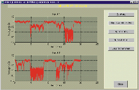
Figure 1. Correlated time-series

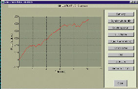
Figure 2. Signal phase series
Figures 1 and 2 illustrate some graphical results
produced with this software package.
Future enhancements
As it has been indicated above, the developed
simulation tool implements the basic features
describing the propagation phenomena found in
a land mobile satellite channel. However a
number of improvements have been identified
which can make the most profitable use of its
results and these are now under study.
Conclusions
A statistical simulation tool for the land
mobile satellite channel has been developed.
This is a fast and flexible tool capable of
providing an accurate reproduction of channel
effects for both moving satellites and mobile
stations in a wide range or operational
environments and frequency bands not only for
mobile communications but also for navigation
and broadcast systems.


 Preparing for the Future Vol. 9 No. 2
Published September 1999.