Using a data cube to monitor forest loss in the Amazon
In brief
- Forest ecosystems are rapidly experiencing the impacts of climate change and timely forest monitoring is growing increasingly urgent.
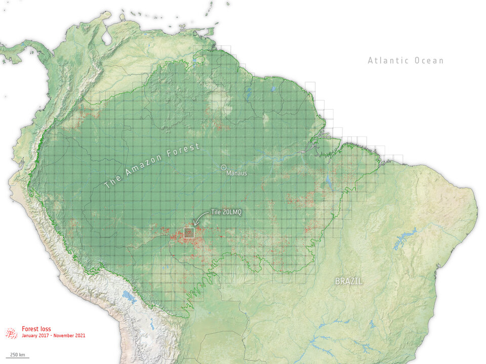
- An ESA-led project, Sentinel-1 for Science: Amazonas, has processed billions of pixels over the entire Amazon basin and converted it into a data cube – helping detect forest loss.
- A data cube is a simple a way of organising and viewing any sort of data with multiple dimensions, some of which are associated with space and time, that can help gain insights into patterns and trends that might not be immediately apparent otherwise.
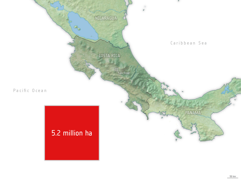
- From January 2017 to November 2021, the team detected forest loss of over 5.2 million hectares, which is roughly the size of Costa Rica.
In-depth
Forests hold a vast amount of Earth’s terrestrial carbon and play an important role in offsetting anthropogenic emissions of fossil fuels. Since 2015, the world’s tropical forests can be observed regularly at an unprecedented 6 to 12 day interval thanks to the Copernicus Sentinel-1 mission.
Millions of gigabytes of synthetic aperture radar (SAR) data are acquired both day and night, regardless of cloud cover, haze, smoke or aerosols, allowing deforestation and forest degradation to be monitored at least biweekly.
The challenge, however, lies in finding adequate methods to extract meaningful indicators of forest loss from the vast amounts of incoming radar data, such that anomalies in the time-series can be regularly and consistently detected across tropical forests.
Such forest-monitoring methods should be transparent and easily understandable to the wider public, enabling confidence in their use across various public and private sectors.
The Sentinel-1 for Science: Amazonas project presents a simple and transparent approach to using Sentinel-1 satellite radar imagery to estimate forest loss. The project uses a space-time data cube design (also known as StatCubes), where statistical information relevant to identify deforestation is extracted at each point in the radar time-series.
With this approach, the project demonstrates the use of Sentinel-1 data to create a dynamic deforestation analysis over the Amazon basin. The team were able to detect forest loss of over 5.2 million hectares from 2017 to 2021, which is roughly the size of Costa Rica.
Neha Hunka, Remote Sensing Expert at Gisat, commented, “What we are seeing from space is over a million hectares of tropical moist forests disappearing each year in the Amazon basin, with the worst year being 2021 in Brazil. We can track these losses and report on them transparently and consistently every 12 days henceforth.”
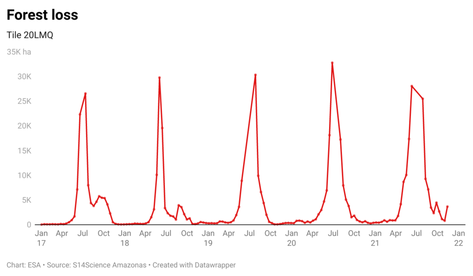
Billions of pixels from the Sentinel-1 satellites from early-2015 to December 2021, each representing a 20 x 20 m of forest, are harmonised under the StatCubes design, and a simple thresholding approach to detect forest loss is demonstrated in the first version of the results.
The largest challenge in the project was the vast amount of data handling and processing. The team used several user-friendly software tools to access the data efficiently – processing over 450 TB of data to create the forest loss maps.
Anca Anghelea, Open Science Platform Engineer at ESA, added, “By providing open access data and code through ESA’s Open Science Data Catalogue, and openEO Platform, we aim to enable researchers around the world to collaborate and contribute to the advancement of knowledge about our global forests and the carbon cycle.
"Thus, in the last phase of the project, a key focus will be on Open Science, reproducibility, long-term maintenance and evolution of the results achieved in the Sentinel-1 for Science: Amazonas Project.”
Following on from the project, the next goal is to achieve a product of carbon loss from land cover changes, working together with ESA’s Climate Change Initiative team – a goal that will contribute to ESA’s Carbon Science Cluster.
The current results of the project are now available by clicking here. Sentinel-1 for Science Amazonas is implemented by a consortium of four partners - Gisat, Agresta, Norwegian University of Life Sciences and the Finnish Geospatial Research Institute. The team uniquely combines complementary and strong backgrounds in forestry and carbon assessments, multi-temporal SAR analysis and data fusion, and large-data processing capabilities.