
An improved view of global sea ice
Earth’s declining ice is without a doubt one of the clearest signs of climate change. A new high-resolution sea-ice concentration data record has just been released as part of ESA’s Climate Change Initiative – providing new insights of sea ice concentration across the globe.
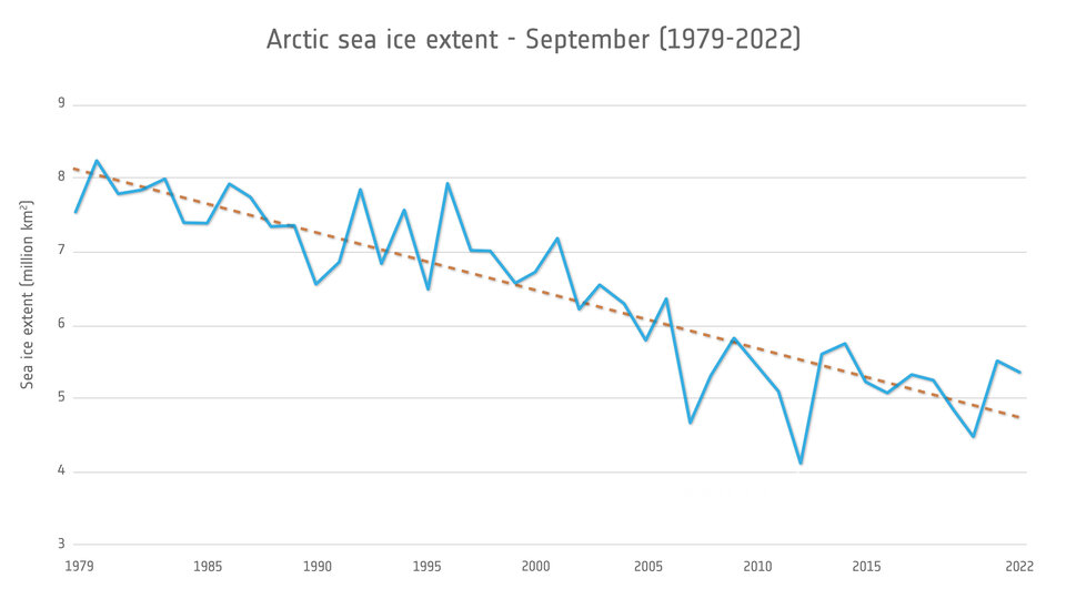
In recent decades, the relentless rise in global temperatures has triggered a concerning reduction in the extent and thickness of sea ice. The Arctic region in particular has witnessed a rapid loss of sea ice, with ESA satellite observations providing alarming evidence of this trend.
The impacts are profound, as it not only disrupts the lives of indigenous communities but also affects polar wildlife, global weather patterns and oceanic currents.
ESA’s Climate Change Initiative’s Sea Ice team has now released a new data record covering 30 years (1991-2020) of sea-ice concentration in higher resolution. Although the dataset isn’t as long as the 40-year records already available, it allows us to see the ice in much more detail.
Thomas Lavergne, senior scientist at the Norwegian Meteorological Institute and science lead for the CCI Sea Ice project, explains, “Our team has processed the high-frequency, higher resolution imagery from the Special Sensor Microwave Imager (SSM/I) and the Special Sensor Microwave Imager Sounder (SSMIS) to obtain a clearer picture of sea ice concentration across the globe.”
“Although the dataset is shorter, it is an advanced, sharpened version of that from Eumetsat OSI SAF and reveals more detail to improve model predictions and understanding of Arctic dynamics.”


Open Image
The data is processed from microwave imagery and Numerical Weather Prediction data through a dedicated algorithm developed by the CCI Sea Ice team. The data were then validated using data from the Copernicus Sentinel-1 radar mission which provides all-weather sea-ice mapping capabilities.
Dirk Notz, from the University of Hamburg, commented, “For the climate research community, the new, high resolution sea-ice product by ESA is really exciting! All around the world, modelling groups are currently developing the next generation of climate models that aim at a grid resolution of just a few kilometres.
“To evaluate these models, and to learn how well we understand the processes that drive the ongoing sea-ice loss on these scales, having access to satellite data with a similar spatial resolution is absolutely crucial. This new product couldn’t be more timely!”
These long-term datasets, compiled with data from numerous satellites, enable researchers to study the long-term trends and variations in the Arctic and Antarctic, contributing to a better understanding of the polar response to global warming and improved prediction of future change.
Thomas Lavergne continues, “We hope that this higher resolution dataset will benefit its users and will help gain new insights about the regional and local scales linking sea ice to other elements of the Earth system.”
This dataset comes a few months after the CCI Sea Ice team released a ‘historical’ sea ice dataset to reveal how sea ice formed in the early 1970s.
The team, using ‘satellite archaeology,’ reprocessed observations from the Electrically Scanning Microwave Radiometer (ESMR) onboard the Nimbus-5 satellite, to derive global sea ice concentration and extent from 1972-1977, which predate sea ice climate data records from modern satellite radiometers (which started in 1979).
Both the new high-resolution dataset and the early-1970s dataset can be accessed and downloaded from the Climate Change Initiative’s Open Data Portal.
Looking ahead
The Special Report for a 1.5°C Global Warming documents that to limit global warming to 1.5°C above pre-industrial levels could ‘substantially’ reduce the risk of sea ice-free summers in the Arctic with respect to a 2°C warming.
Although satellite observations are the foundation for most of our knowledge about the evolution of the global sea ice cover, progress is still acutely needed to improve the observations of the Sea Ice Essential Climate Variable, in particular to achieve better spatial resolution, better consistency across satellite missions and longer time series.
The data collected not only enhance our knowledge of sea ice concentration, but also support decision-making processes and the development of effective mitigation and adaptation strategies.
Governments, policymakers and scientific communities rely heavily on these satellite observations to assess the environmental impact, predict future scenarios, and inform policies for sustainable management of the Arctic region.
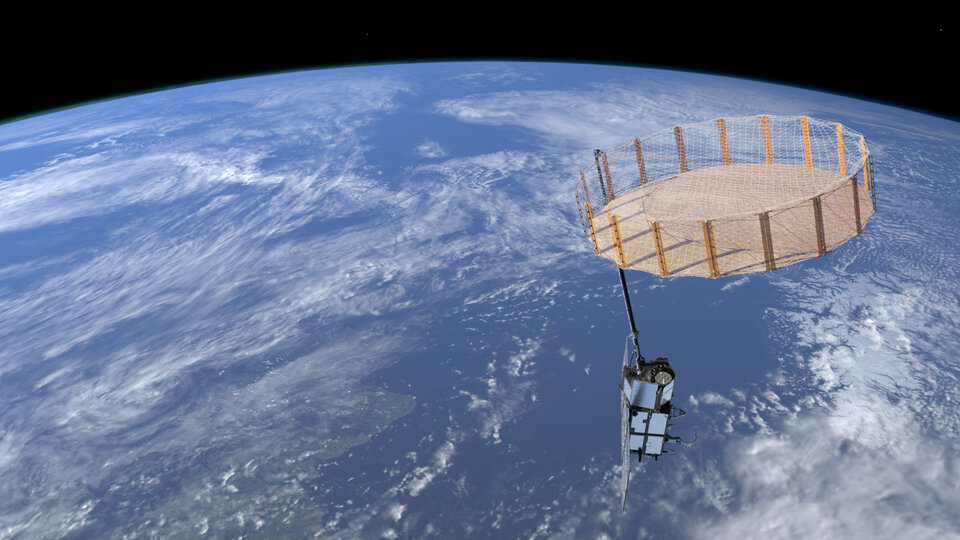
The importance of the Arctic is reflected in the Copernicus programme that is now evolving to implement new satellite capabilities prioritising new Arctic measurements that are urgently needed by Copernicus Services.
This includes the upcoming Copernicus Imaging multi-frequency Microwave Radiometer (CIMR) and the Copernicus Polar Ice and Snow Topography Altimeter (CRISTAL) missions that will together provide the sustained, long-term observations needed for polar climate monitoring, climate research and marine services.


