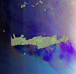
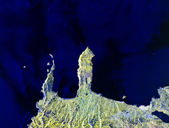
United space in Europe
Northwestern Crete
Applications

Northwestern Crete

29/05/2013 2742 views 27 likes 292243 ID
  • HI-RES JPG [671.69 kB]
  • HI-RES TIF [63.24 MB]

Thank you for liking

You have already liked this page, you can only like it once!

This image shows northwestern Crete, the largest and most populous of the Greek islands. It is a compilation of three radar images from Japan’s ALOS satellite acquired on 28 August 2010, 13 October 2010 and the third band created by combining the other two. In the lower-right, the bright cluster of radar reflections on the northern coast is the city of Chania, the island’s second largest city after Heraklion (not pictured). At the centre of the image is the Rodopou Peninsula. Off the coast of the other peninsula to the left there are two small islands: Imeri Gramvousa to the south and Agria Gramvousa due north.

This image is featured on the Earth from Space video programme.

  • JAXA, ESA
  • Observing the Earth
  • ALOS Third-Party missions
  • Greece Crete
  • Radar Images Satellite image
  • Earth observation image of the week
The island of Crete
Applications

The island of Crete

Image 2523 views 17 likes
Βορειοδυτική Κρήτη
Applications

Βορειοδυτική Κρήτη

Image 674 views 4 likes
Greece’s largest and most populous island.
Applications

Earth from Space: Crete

Video 00:02:56 1378 views 10 likes
Northwestern Greece
Applications

Northwestern Greece

Image 3227 views 26 likes
Ellesmere Island and northwestern Greenland
Applications

Ellesmere Island and northwestern Greenland

Image 1538 views 13 likes