Colours of Sweden
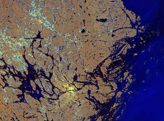
This image is a composite of radar scans by Sentinel-1A on different dates of the Siljan Ring, located in the province of Dalarna in central Sweden.
Dalarna, a historical province known for its deep forests, beautiful fishing lakes and lush green landscapes, is a holiday residence for many Swedes and a favourite tourist attraction.
Sweden’s sixth largest lake, Siljan covers an area of 290 sq km. Its particular shape comes from the location around the southwestern perimeter of the Siljan Ring, a circular geological formation created almost 400 million years ago by a major meteorite impact.
Mainly eroded today, the original crater is estimated to have been some 50 km in diameter. It is the largest known impact crater in Europe and one of the 18 largest known impact craters on Earth.
Three scans of the area taken at different dates were overlaid, with different colours assigned to each: red (7 February 2015), green (15 March 2015) and blue (27 March 2015). The colours represent changes on the ground between the various acquisitions.
Given the location and the time of year, it is safe to infer that the landscape was dominated by vegetated areas, partly or completely frozen lakes and lots of snow. It is probably also safe to assume that most changes are related to variations in snow cover and snow condition.
Focusing on the Siljan Lake, towards the central right part of the image, it is easy to make out the bright red and green lines, which come from changes in the ice edge and cover on the lake, in early spring.
Southeast of the lake area, the town of Borlänge is clearly visible along the Dal River, appearing as bright white. Famous for its medieval cathedral of Stora Tuna and its important rail and bus junction, it became a commercial centre for the surrounding agricultural and industrial areas. The town has paper mills, sawmills, engineering works, foundries, printing establishments and factories.
The strikingly sharp blue to the east of Borlänge probably represents fresh snow, which fell sometime around the end of March and covered the flat agricultural fields, thus changing the ground properties.
Sentinel-1A has been in orbit since 3 April 2014. It is a polar-orbiting, all-weather, day-and-night radar imaging mission for land and ocean services, monitoring the marine environment and mapping water and soil surfaces, among other major applications.
This image is also featured on the Earth from Space video Programme.