

Eduspace website expanded and extended to Greece
For many years, ESA’s Eduspace website has been a window on the world for secondary students and teachers, providing an invaluable introduction to Earth observation and its applications. The site has now been updated and improved with new case studies and a Greek version.
Today’s meteorologists rely heavily on data sent back by satellites, including Europe’s Meteosat and MetOp. However, many people are not aware of how the satellite data are analysed and contribute to the daily forecasts.
The new 'Interactive Meteosat' section covers many different aspects of weather forecasting – something that affects all of our lives. It includes introductory pages on weather and climate, and a selection of images of Europe sent back from Meteosat.
The case study also includes four worksheets with various exercises related to satellite pictures taken at different wavelengths. These enable students to analyse the images, locate weather systems and recognise differences in atmospheric conditions.
The final worksheet brings everything together by asking students to make their own measurement and their forecast.
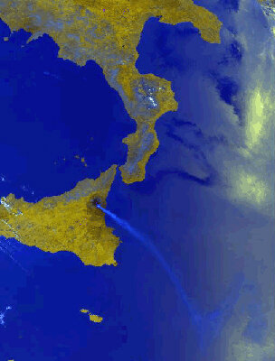
Another new section covers one of nature’s most spectacular and powerful creations: volcanoes.
One of the world’s best known examples is Mt Etna in Sicily, and three worksheets are devoted to satellite images of Europe’s most active volcano. These enable students to explore the volcano, and to detect and monitor hot spots and plumes of ash.
The section also investigates two African volcanoes – Nyiragongo and Nyamuragira – which are much more dangerous than Etna.
The exercises enable students to analyse Landsat images, in order to identify changes over time in lava flows and ash plumes.
Another notable addition is the introduction of a Greek version of the website. In recognition of the multinational membership of ESA, Eduspace is now available in nine languages: English, French, German, Danish, Dutch, Italian, Spanish, Portuguese and Greek.
The Eduspace website was developed to introduce Earth observation techniques and applications to secondary school students, although some material is also suited to university undergraduate level.
Since its launch in 1998, it has provided an invaluable educational resource by making available catalogues of Earth imagery and a sophisticated image processing software package called LEOWorks, which enables satellite imagery to be manipulated and analysed on school computers.
The cornerstones of the website are the case studies. They provide teachers and students with examples of in-depth studies within a particular theme.
The background information and varied exercises provide a valuable source of ideas on how to introduce Earth observation from space into the classroom.

