• → European Space Agency

      • Space for Europe
      • Space News
      • Space in Images
      • Space in Videos
    • About Us

      • Welcome to ESA
      • DG's News and Views
      • For Member State Delegations
      • Business with ESA
      • ESA Exhibitions
      • ESA Publications
      • Careers at ESA
    • Our Activities

      • Space News
      • Observing the Earth
      • Human Spaceflight
      • Launchers
      • Navigation
      • Space Science
      • Space Engineering
      • Operations
      • Technology
      • Telecommunications & Integrated Applications
    • For Public

    • For Media

      • Media
      • ESA TV
      • Videos for professionals
      • Photos
    • For Educators

    • For Kids

    • ESA

    • Navigation

    • EGNOS

    • Galileo

    • Evolution

    • About satellite navigation
    • Europe's satellite navigation services
    • Resources
    • Development Facilities
    • Navipedia
    • Multimedia
    • Galileo's In-Orbit Validation phase - 2012 video
    • Galileo - Europe leads the way 3D video
    • Image gallery
    • Video gallery
    • Documents
    • Galileo factsheet (PDF)
    • Galileo IOV factsheet (PDF)
    • Galileo FOC factsheet (PDF)
    • GNSS Evolution factsheet (PDF)
    • Galileo IOV brochure (PDF)
    • Galileo IOV brochures in French and German (PDF)
    • Archives
    • News archive
    • Navigation projects
    • Services
    • Subscribe

    ESA > Our Activities > Navigation

    The Maritime LOPOS EGNOS Test Bed (MARLET)

    Ship moving into harbour
    EGNOS navigation information will compliment radar signals

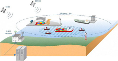
    The aim of this project was the demonstration of the European Geostationary Overlay Service (EGNOS) in the maritime environment in two domains: Hamburg port operations and in the context of the forthcoming installation of AIS transponders aboard seagoing vessels.

    In particular, the following tasks were performed:

    • An examination of integrity for the LOPOS-generated GPS / GLONASS correctional data
    • A performance comparison between local production of correction data and use of EGNOS
    • A test of the operative use of EGNOS for commercial applications in shipping
    • An investigation of the suitability of EGNOS for alternative navigational solutions – namely AIS – for the intelligent and selective reduction in the amount of data to be transferred.

    The MARLET project was initiated in December 2001 and was completed in December 2002.

    Last update: 8 February 2006

    Rate this

    Views

    Share

    • Currently 0 out of 5 Stars.
    • 1
    • 2
    • 3
    • 4
    • 5
    Rating: 0/5 (0 votes cast)

    Thank you for rating!

    You have already rated this page, you can only rate it once!

    Your rating has been changed, thanks for rating!

    52
    Tweet
    • Related news
      • Safer harbour operations with EGNOS
      • Related links
      • MARLET project page
      • Lopos Technologies
      • Documentation
      • Final presentation (.pdf 1.6 Mb)

    Connect with us

    • RSS
    • Youtube
    • Twitter
    • Flickr
    • G+
    • Facebook
    • Livestream
    • Subscribe
    • App Store
    • LATEST ARTICLES
    • · Rare merger reveals secrets of gal…
    • · Watching for hazards: ESA opens as…
    • · ESA astronaut Timothy Peake set fo…
    • · Space drives e-mobility
    • · Proba-V opens its eyes
    • FAQ

    • Jobs at ESA

    • Site Map

    • Contacts

    • Terms and conditions