Charter sets satellites on call for the world's disasters
Volcanic eruptions, earthquakes, landslides, flooding, forest fires…when major catastrophes strike, emergency operations require first and foremost precise information to act efficiently. Reacting swiftly and in the most urgent areas is paramount. This week EuroNews finds out how satellites can help.
Since November 2000, an International Space and major Disasters Charter, has been operational, coordinating all available space resources each time a catastrophe arises.
EuroNews 'Space' magazine visited one of the Charter's coordination centres, based at ESA 's Space Research Institute (ESRIN) at Frascati near Rome, to learn more about the way the Charter works.
The Charter was created by the European Space Agency with the French and Canadian space agencies. The space agencies of the United States, India and Argentina have since joined. Japan is preparing to do so, and the United Nations is an active 'cooperating body'.
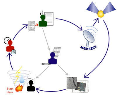
The Charter has been triggered more than 70 times: around the world, a civil protection or national agency sends a fax to ESA/ESRIN. The Charter is manned 24 hours a day, 7 days a week, year in year out.
After verifying the fax authenticity and essential details, an emergency on-call officer checks the availabilty of satellites and coordinates the acquisition planning to provide images and other data of the region concerned.

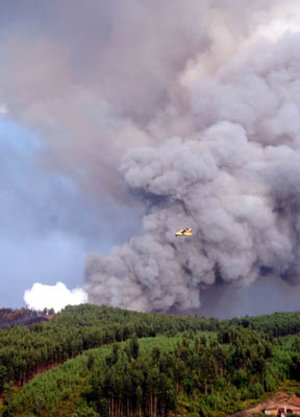
A Canadian radar satellite may then, for instance, be programmed to obtain data on forest fires in Portugal; a French SPOT satellite may collect pictures of a lava flow in East Africa; ERS-2 or Envisat may obtain maps of widespread flooding in Central Europe.
Once a satellite has passed over the disaster area, its data are made available to the Charter's coordination centre. Information relevant to the emergency is then extracted and sent to the authorities directly involved.
This may involve providing details of road networks to get to the scene or comparative data showing the affected regions before disaster struck. In this respect, the Charter can draw on the important Earth-observation satellite archives, which are kept at ESRIN.
The Charter personnel that EuroNews met and interviewed at ESRIN are all dedicated to their work. "Since the Charter became operational we have certainly saved many lives," says Francesco Sarti of ESA's Earth Observation Directorate. "But the more we achieve, the more it is generally recognised that not only additional resources such as satellite systems must come on line, but civil protection agencies must be trained and made more aware of the ways in which they and the Charter can work together."
EuroNews
EuroNews is a key medium for delivering international information with a European point of view. Broadcast in 79 countries, EuroNews reaches 144 million households in Europe, the Middle East, Africa, Central Asia and North and Latin America via cable, digital satellite and through terrestrial channels.
This Space Magazine is produced and broadcast every two weeks, with a new programme starting every second Friday. Each magazine is four minutes long and broadcast 21 times in one week, including evening prime time on Fridays and Saturdays, in order to reach a maximum audience.
Broadcast times
| Monday | 12:45 | 18:15 | 00:15 | |
|---|---|---|---|---|
| Tuesday | 12:45 | 18:15 | 00:15 | |
| Wednesday | 12:45 | 18:15 | 00:15 | |
| Thursday | 12:45 | 18:15 | 00:15 | |
| Friday | 17:45 | 20:45 | 00:15 | |
| Saturday | 12:45 | 21:15 | 00:15 | |
| Sunday | 12:45 | 18:15 | 00:15 |