• → European Space Agency

      • Space for Europe
      • Space News
      • Space in Images
      • Space in Videos
    • About Us

      • Welcome to ESA
      • DG's News and Views
      • For Member State Delegations
      • Business with ESA
      • ESA Exhibitions
      • ESA Publications
      • Careers at ESA
    • Our Activities

      • Space News
      • Observing the Earth
      • Human Spaceflight
      • Launchers
      • Navigation
      • Space Science
      • Space Engineering
      • Operations
      • Technology
      • Telecommunications & Integrated Applications
    • For Public

    • For Media

    • For Educators

    • For Kids

    • ESA

    • Observing the Earth

    • Understanding Our Planet

    • Securing Our Environment

    • Benefiting Our Economy

    • About Observing the Earth
    • How does Earth Observation work?
    • How to get Earth observation data
    • Integrating Earth Observation in your job
    • Earth Observation users speak
    • EO programmes
    • The Living Planet
    • GMES
    • ESA's Earth Observing missions
    • Envisat overview
    • ERS overview
    • Earth Explorers overview
    • Sentinels overview
    • MSG overview
    • MetOp overview
    • Proba-1 overview
    • Third Party Missions overview
    • Opportunities with us

      • Education & training
      • International cooperation
      • Milestones & announcements
    • Multimedia

      • Image Gallery
      • Video Gallery
      • Online resources
      • RSS feeds
    • Services
    • Subscribe

    ESA > Our Activities > Observing the Earth

    Earth from Space: The Netherlands

    21 November 2008

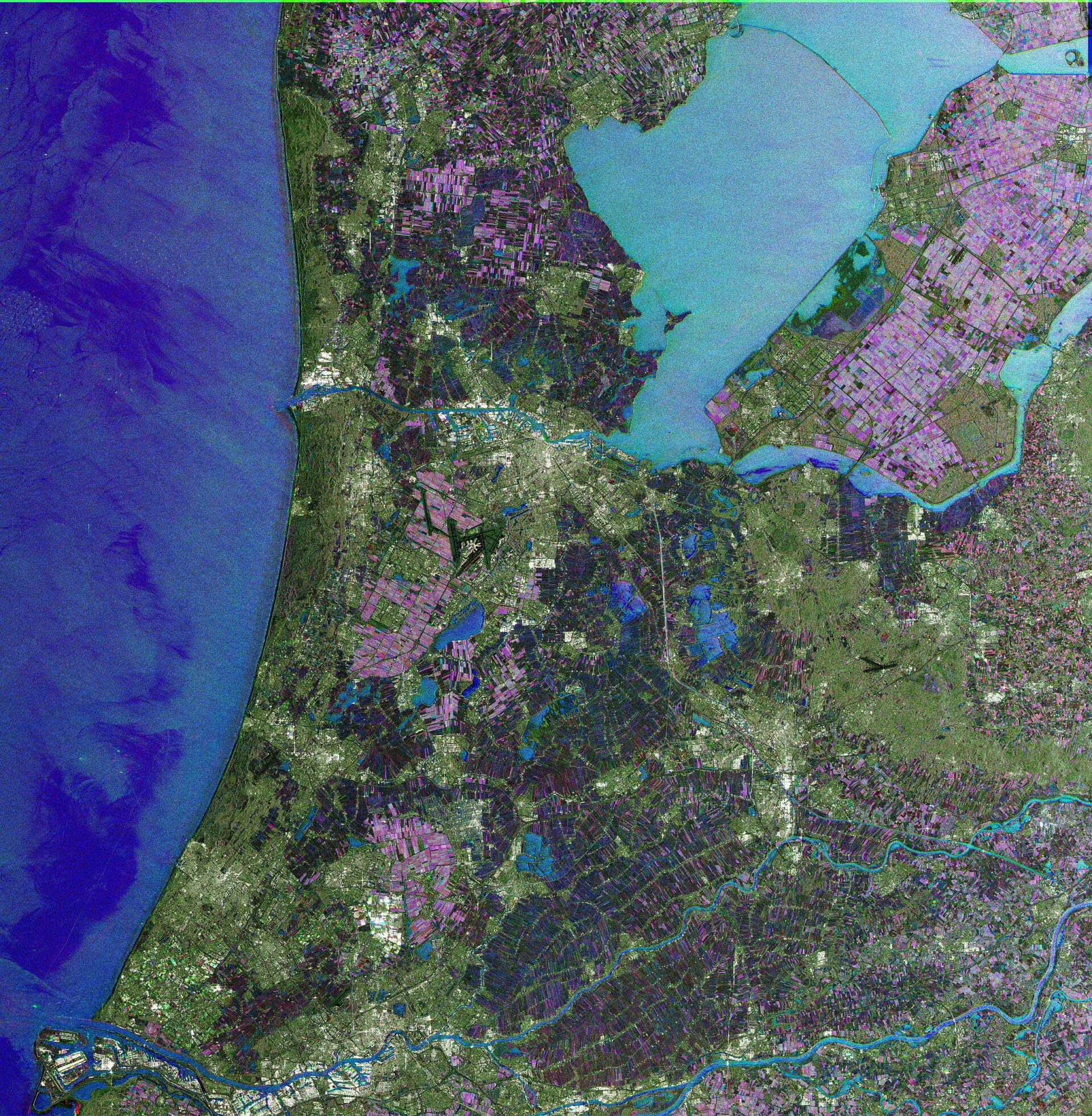
    This Envisat image features the Netherlands, with the capital city of Amsterdam visible in white on the south bank of the waterway (North Sea Canal) extending in an east-west direction left above image centre.

    Above the North Sea Canal between the North Sea (left) and the Markermeer (a shallow lake in the centre of the country), the southern part of the province of North Holland is visible. Located on the eastern (right) side of the Markermeer is the province of Flevoland, a very flat area made up of reclaimed land that is used for agriculture.

    The port of Rotterdam (visible in bottom left corner) and the province of Zeeland, are both visible at the bottom left of the image. Rotterdam port is the largest port in Europe, stretching over 40 km in length and covering 10 000 hectares. It has a depth of 24 m.

    Rotterdam (visible inland from the port) is the country’s second largest city after Amsterdam. The city centre is situated on the northern bank of the New Meuse River, which divides the municipality into its northern and southern parts.

    The Hague, the country’s third largest city, is visible along the coast above the port of Rotterdam. The Hague will play host to ministers in charge of space activities within the 18 ESA Member States and Canada on 25 and 26 November 2008 when the Agency will implement the European Space Policy, setting out the start of future programmes and taking decisions on the next phases of on-going programmes.

    Just north of the Hague is the coastal town of Noordwijk, home to ESA's European Space Technology Research Centre (ESTEC). The Netherlands’ fourth largest city, Utrecht, is clearly seen in white to the right below image centre.

    Because radar images represent surface backscatter rather than reflected light, there is no colour in a standard radar image. Instead the colour in this image is due to it being a multitemporal composite, made up of three Advanced Synthetic Aperture Radar (ASAR) images acquired on different dates, with separate colours assigned to each acquisition.

    In this composite, blue relates to an acquisition on 12 March 2008, green to one on 30 July 2008 and red to one on 28 November 2007.

    Rate this

    Views

    Share

    • Currently 0 out of 5 Stars.
    • 1
    • 2
    • 3
    • 4
    • 5
    Rating: 0/5 (0 votes cast)

    Thank you for rating!

    You have already rated this page, you can only rate it once!

    Your rating has been changed, thanks for rating!

    12
    facebook
    twitter
    reddit
    google plus
    digg
    tumbler
    digg
    blogger
    myspace
    • Image of the week archive
    • Satellite Images
      Satellite Images
      Earth images gallery
    • Related missions
      • Envisat overview

    Connect with us

    • RSS
    • Youtube
    • Twitter
    • Flickr
    • Google Buzz
    • Subscribe
    • App Store
    • LATEST ARTICLES
    • · CryoSat hits land
    • · Ariane 5 completes seven launches …
    • · Measuring skull pressure without t…
    • · Malargüe station inauguration
    • · The solar wind is swirly
    • FAQ

    • Jobs at ESA

    • Site Map

    • Contacts

    • Terms and conditions