France's SPOT satellites assist in South Asia
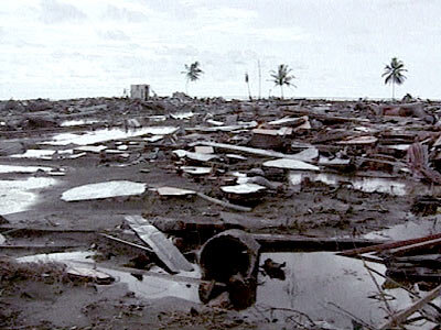
The human tragedy and widespread desolation caused by the tsunami which hit Asia on 26 December will be, according to the United Nations, the biggest ever natural catastrophy to hit our planet. EuroNews has followed up an earlier report on the International Space and major Disasters Charter - created by ESA and of which the United Nations is an active cooperative body - by seeing exactly how space resources have been employed after the tsunami disaster.
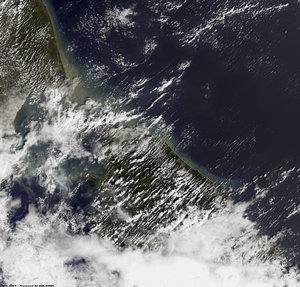
France's SPOT-5, with its 2.5m resolution, has been one of the principal satellites used to assist rescue and reconstruction efforts. The satellite is managed and commercialised by Spot Image in Toulouse.

"The catastrophe occurred on a Sunday, but we always have a stand-by cell, 24 hours a day, 7 days a week," recalls Laurent Maggiori, industrial director at the company. "So by that same evening, we had mobilised our teams so that on the Monday we were able to reprogram our constellation of three satellites to observe the South Asia region."
The Disasters Charter had been activated by several partners: the Indian and French space agencies, and UNOSAT which distributes satellite-based geographical imagery.
Since 27 December SPOT-5, together with sister craft SPOT-2 and SPOT-4, have turned their cameras towards the stricken areas on a daily basis. "The satellites operate in what we call a phased mode," explains colleague Guy Pierre. "They follow each other at 30-40 minute intervals and as the Earth rotates, the constellation can quickly obtain a global coverage."
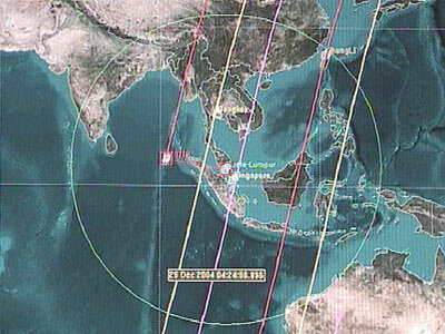
Spot Image has ground stations in Kuala Lumpur, Malaysia and Singapore. Their antennae were able to receive pictures from the satellites several times on the day following the disaster.
Ascertaining the extent of the devastation is done by comparing views taken before and after the devastation. Spot Image has an archive of some 10 million views of our planet. "SPOT-5 has been able to reconstruct the terrain and allow us to create an altimetric database," says Eric Duclos-Gendreu, who coordinates Spot Image's role in the Disasters Charter. "Together with optical views we obtain 3D scenes which have been very useful."

The constellation also provide colour and infrared pictures. "Having colour views, which give an idea of ground composition, enable us to give a very precise account of the surface conditions of an area," adds Pascal Michel, geographical specialist at Spot Image. New maps of, for instance, the Meulaboh region of Indonesia – some 800 sq. kilometres - were thus provided very rapidly to local rescue services and international organisations.

Amongst these were France's navy which had requested updated maps to plan helicopter flights into the area. "The helicopters operating from the aircraft carrier Jeanne d'Arc had to know where exactly they could land to bring food and medical assistance to the local populations," confirms Fabrice Triffaut, international relations spokesman for France's Defence Ministry.
Together with other spacecraft mobilised by the Disasters Charter, the "space eyes" of the SPOT constellation saved time and money, allowing all involved to get quickly to the right places. Practically 8000 pictures of the tsunami-hit areas were obtained by the SPOT satellites in the three weeks following the disaster.
This Earth observation special effort will continue for many months. After tending to the immediate requirements, satellite data from Spot Image will now be used to rebuild these regions and allow them to see a new future.
EuroNews
EuroNews is a key medium for delivering international information with a European point of view. Broadcast in 79 countries, EuroNews reaches 144 million households in Europe, the Middle East, Africa, Central Asia and North and Latin America via cable, digital satellite and through terrestrial channels.
This Space Magazine is produced and broadcast every two weeks, with a new programme starting every second Friday. Each magazine is four minutes long and broadcast 21 times in one week, including evening prime time on Fridays and Saturdays, in order to reach a maximum audience.
Broadcast times
| Monday | 12:45 | 18:15 | 00:15 | |
|---|---|---|---|---|
| Tuesday | 12:45 | 18:15 | 00:15 | |
| Wednesday | 12:45 | 18:15 | 00:15 | |
| Thursday | 12:45 | 18:15 | 00:15 | |
| Friday | 17:45 | 20:45 | 00:15 | |
| Saturday | 12:45 | 21:15 | 00:15 | |
| Sunday | 12:45 | 18:15 | 00:15 |