• → European Space Agency

      • Space for Europe
      • Space News
      • Space in Images
      • Space in Videos
    • About Us

      • Welcome to ESA
      • DG's News and Views
      • For Member State Delegations
      • Business with ESA
      • ESA Exhibitions
      • ESA Publications
      • Careers at ESA
    • Our Activities

      • Space News
      • Observing the Earth
      • Human Spaceflight
      • Launchers
      • Navigation
      • Space Science
      • Space Engineering
      • Operations
      • Technology
      • Telecommunications & Integrated Applications
    • For Public

    • For Media

    • For Educators

    • For Kids

    • ESA

    • GOCE

    • Earth Explorers

    • Observing the Earth

    • Living Planet

    • GOCE at a glance
    • The first of a series
    • Looking into the forces that shape our planet
    • A technological achievement
    • An intimate portrait of Earth
    • Facts and figures
    • About the spacecraft

      • Satellite
      • Payload
    • About the launch

      • Launch overview
      • Launcher
      • After launch
      • GOCE data
    • Meet the team

      • Danilo Muzi, Project Manager
      • Rune Floberghagen, Mission Manager
      • Reiner Rummel, Chairman Mission Advisory Group
      • Mark Drinkwater, Mission Scientist
      • Roger Haagmans, Mission Scientist
      • Andrea Allasio, Thales Alenia Space Project Manager
      • Michael Fehringer, System Manager
      • Paolo Laberinti, Head of Verification and Testing
      • Miguel Aguirre, Technical Officer for Definition Phase
      • Daniel Lamarre, Gradiometer Engineer
      • Juan Piñeiro, Spacecraft Operations Manager
      • Stefano Capitanio, Launch Campaign Manager
      • Pascal Gilles, Head of Earth Explorer Payload Data Ground Segment
    • Multimedia
    • Image gallery
    • Videos
    • Online resources

    ESA > Our Activities > Observing the Earth > GOCE

    GOCE’s second mission improving gravity map

    Improved spatial resolution
    16 November 2012

    ESA’s GOCE gravity satellite has already delivered the most accurate gravity map of Earth, but its orbit is now being lowered in order to obtain even better results.

    The Gravity field and steady-state Ocean Circulation Explorer (GOCE) has been orbiting Earth since March 2009, reaching its ambitious objective to map our planet’s gravity with unrivalled precision.

    Although the planned mission has been completed, the fuel consumption was much lower than anticipated because of the low solar activity over the last two years. This has enabled ESA to extend GOCE’s life, improving the quality of the gravity model.

    To be able to measure the strength of Earth’s gravity, the satellite was flying in an extraordinarily low orbit about 255 km high – about 500 km lower than most Earth observation satellites.

    Based on a clear preference from the GOCE user community, ESA’s Earth Scientific Advisory Committee recommended lowering the orbit to 235 km starting in August.

    Counteracting drag

    Lowering the orbit increases the accuracy and resolution of GOCE’s measurements, improving our view of smaller ocean dynamics such as eddy currents.

    The control team began the manoeuvres in August, lowering GOCE by about 300 m per day.

    After coming down by 8.6 km, the satellite’s performance and new environment were assessed. Now, GOCE is again being lowered while continuing its gravity mapping. Finally, it is expected to reach 235 km in February.

    As the orbit drops, atmospheric drag increasingly pulls the satellite towards Earth. But GOCE was designed to fly low, the tiny thrust of its ion engine continuously compensating for any drag.

    The expected increase in data quality is so high that scientists are calling it GOCE’s ‘second mission.’


    New GOCE geoid
    New GOCE geoid

    “For us at ESA, GOCE has been a fantastic mission and it continues to surprise us,” said Volker Liebig, ESA’s Director of Earth Observation Programmes.

    “What the team of ESA engineers is now doing has not been done before and it poses a challenge. But it will also trigger new research in the field of gravity based on the high-resolution data we are expecting.”

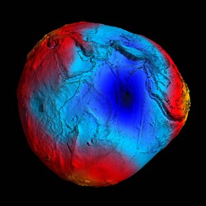
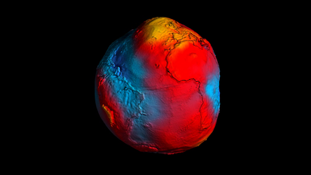
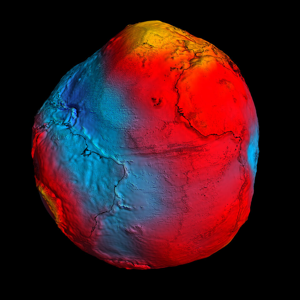
    The first ‘geoid’ based on GOCE’s gravity measurements was unveiled in June 2010. It is the surface of an ideal global ocean in the absence of tides and currents, shaped only by gravity.

    A geoid is a crucial reference for conducting precise measurements of ocean circulation, sea-level change and ice dynamics.

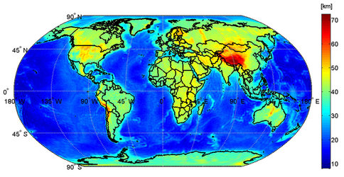
    The mission has also been providing new insight into air density and wind in space, and its information was recently used to produce the first global high-resolution map of the boundary between Earth’s crust and mantle.

    Rate this

    Views

    Share

    • Currently 5 out of 5 Stars.
    • 1
    • 2
    • 3
    • 4
    • 5
    Rating: 5/5 (1 votes cast)

    Thank you for rating!

    You have already rated this page, you can only rate it once!

    Your rating has been changed, thanks for rating!

    667
    facebook
    twitter
    reddit
    google plus
    digg
    tumbler
    digg
    blogger
    myspace
    • GOCE
    • GOCE first global gravity model
      GOCE first global gravity model
      Access GOCE data
    • Related news
      • Gravity satellite to benefit future missions
        • Mapping the Moho with GOCE
          • Earth's gravity revealed in unprecedented detail

    Connect with us

    • RSS
    • Youtube
    • Twitter
    • Flickr
    • Google Buzz
    • Subscribe
    • App Store
    • LATEST ARTICLES
    • · CryoSat hits land
    • · Ariane 5 completes seven launches …
    • · Measuring skull pressure without t…
    • · Malargüe station inauguration
    • · The solar wind is swirly
    • FAQ

    • Jobs at ESA

    • Site Map

    • Contacts

    • Terms and conditions