• → European Space Agency

      • Space for Europe
      • Space News
      • Space in Images
      • Space in Videos
    • About Us

      • Welcome to ESA
      • DG's News and Views
      • For Member State Delegations
      • Business with ESA
      • ESA Exhibitions
      • ESA Publications
      • Careers at ESA
    • Our Activities

      • Space News
      • Observing the Earth
      • Human Spaceflight
      • Launchers
      • Navigation
      • Space Science
      • Space Engineering
      • Operations
      • Technology
      • Telecommunications & Integrated Applications
    • For Public

    • For Media

    • For Educators

    • For Kids

    • ESA

    • Observing the Earth

    • Understanding Our Planet

    • Securing Our Environment

    • Benefiting Our Economy

    • About Observing the Earth
    • How does Earth Observation work?
    • How to get Earth observation data
    • Integrating Earth Observation in your job
    • Earth Observation users speak
    • EO programmes
    • The Living Planet
    • GMES
    • ESA's Earth Observing missions
    • Envisat overview
    • ERS overview
    • Earth Explorers overview
    • Sentinels overview
    • MSG overview
    • MetOp overview
    • Proba-1 overview
    • Third Party Missions overview
    • Opportunities with us

      • Education & training
      • International cooperation
      • Milestones & announcements
    • Multimedia

      • Image Gallery
      • Video Gallery
      • Online resources
      • RSS feeds
    • Services
    • Subscribe

    ESA > Our Activities > Observing the Earth

    Earth from Space: Lake Chad

    21 December 2007

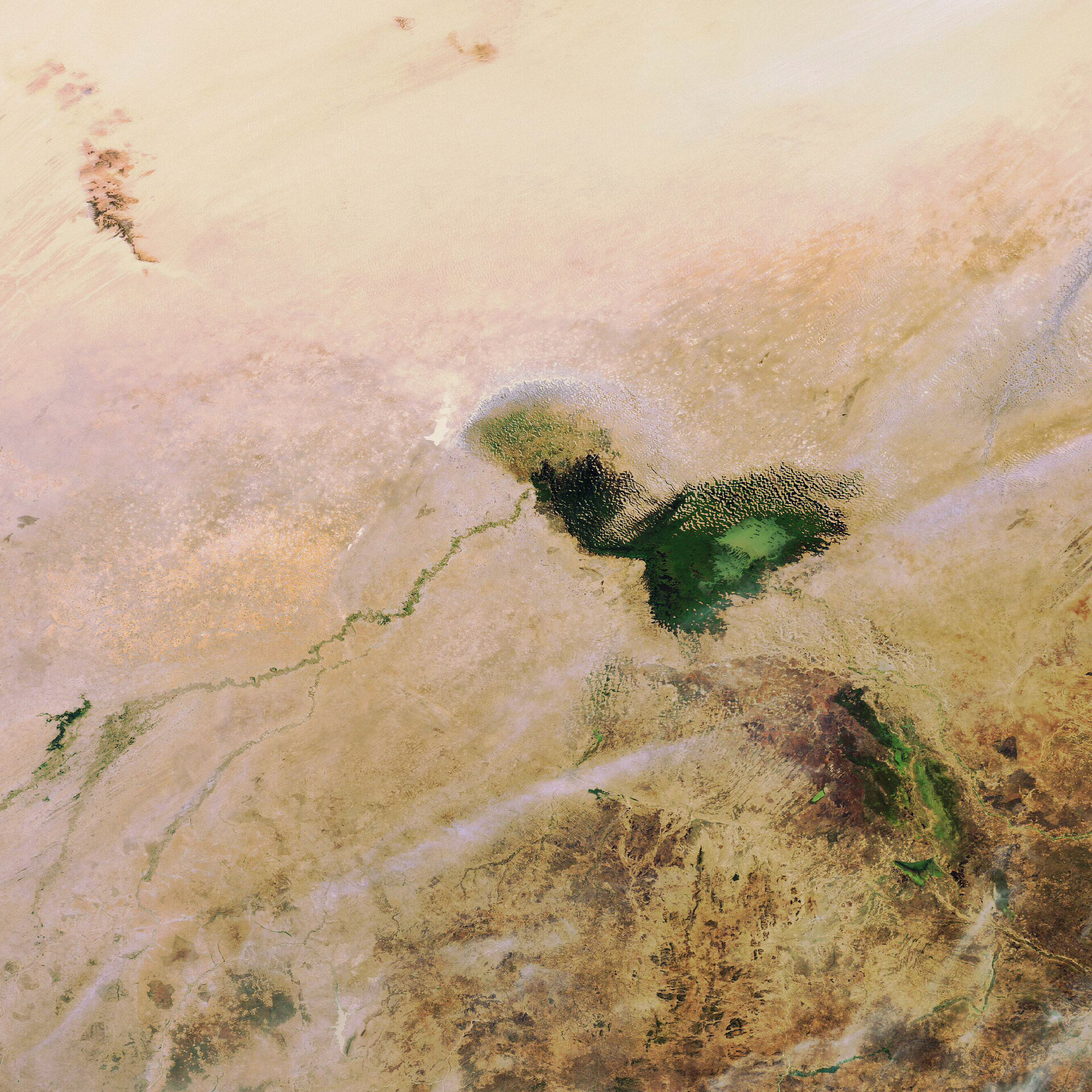
    This Envisat image highlights Lake Chad, a freshwater lake located in central Africa at the junction of Chad, Cameroon, Nigeria and Niger.

    Lake Chad, once Africa’s third largest inland water body, is located in West Africa’s Sahel region – a transition zone between the Sahara Desert to the north and savannas and woodlands to the south.

    Because the lake is shallow, between 1 m in the northwest and 7 m in the south, it has always undergone seasonal fluctuations. However, it has shrunk dramatically over the last four decades due to a decrease in rainfall and an increase in the amount of water used for irrigation projects. Lake Chad’s surface area was 25 000 sq km in the early 1960s, compared with 1350 sq km in 2001.

    Lake Chad is fed primarily by the Chari and Logone Rivers, which are both located in the southwest and flow northward into the lake, which doubles in size during the rainy season.

    This 19 December 2007 image was acquired by the Medium Resolution Imaging Spectrometer (MERIS) instrument on Envisat, working in Full Resolution mode.

    Rate this

    Views

    Share

    • Currently 0 out of 5 Stars.
    • 1
    • 2
    • 3
    • 4
    • 5
    Rating: 0/5 (0 votes cast)

    Thank you for rating!

    You have already rated this page, you can only rate it once!

    Your rating has been changed, thanks for rating!

    12
    facebook
    twitter
    reddit
    google plus
    digg
    tumbler
    digg
    blogger
    myspace
    • Image of the week archive
    • Satellite Images
      Satellite Images
      Earth images gallery
    • Related missions
      • Envisat overview
      • In French
        • La Terre vue de l'Espace: Le « fleuve de l’unité nationale » au Brésil

    Connect with us

    • RSS
    • Youtube
    • Twitter
    • Flickr
    • Google Buzz
    • Subscribe
    • App Store
    • LATEST ARTICLES
    • · CryoSat hits land
    • · Ariane 5 completes seven launches …
    • · Measuring skull pressure without t…
    • · Malargüe station inauguration
    • · The solar wind is swirly
    • FAQ

    • Jobs at ESA

    • Site Map

    • Contacts

    • Terms and conditions