| | | | |
 |
|
Coastal change Danube Delta change detectionOil spillsDeforestation Bardia National ParkCongo River BasinKameng-Sonitpur Elephant ReserveKilimanjaroRondoniaShillong and GuwahatiIce Antarctica 2003Climate change and glaciersGlacier analysis using radar imageryGlacial retreat in the AlpsGlacier Ice FlowMonitoring of glaciers in the HimalayasRemote sensing of ice and snowUrbanisation CairoCity of KathmanduCórdobaHimalayasKathmandu ValleyLagosVegetation Annapurna Conservation AreaLost in the AndesNgorongoro Conservation AreaNiger Inland DeltaVegetation in South America
| | | | | | | Landscape and land cover dynamics in the Karnali Floodplain - Part 2
This exercise is divided into two parts and requires the use of LEOWorks.
We will continue working with the images 'Bardia_landsat_2002_band 7' and 'Bardia_landsat_1990_band 7'.
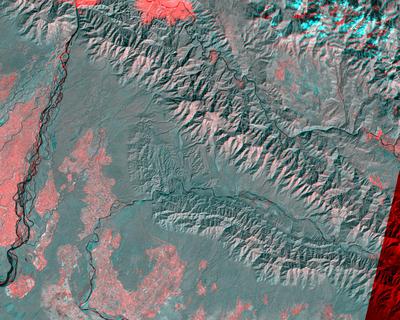
Generate still images by producing a Combined Image using Red for 2002 (band4), Green for 1990 (band4), and Blue for 1990 (band4).
The image displayed in red covers the situation in a Landsat ETM satellite image of 2 February 2002, and the image displayed in green and blue is the one recorded by the Landsat TM satellite on 8 November 1990. The stronger reflection of chlorophyll in the near infrared band 4 in 2002 leads to a reddish coloured vegetation in this combination.
1. Explain why. Is the change a result of time or just seasonal?
2. Explain the large, red patch in the upper part of the image.
3. What is the significance of the cyan colour?
Difference image: Red 2002, Blue-Green 1990 (BNP)
There is something especially interesting in this 'difference' image. Since the two images were acquired from different orbits (resulting in a different viewing angle) they have also strangely flipped in the image animation exercise. We can use this to visualise them in 3-D. For doing this you have to view your difference image (shown above) with a red-cyan glass and, as if by magic, you would see it in 3-D!
| |
| | Bardia National Park IntroductionLocationGeology and soilWeather and climatePeople and settlementsExercises Worksheet introductionOverview - working on paper printsBardia Region Overview - Image processingLandscape and land cover dynamics in the Karnali FloodplainHabitat suitability evaluation for rhinoceros in BardiaEduspace - Software LEOWorks 3ArcExplorerEduspace - Download bardia.zipbardia_paperprints.zipResources Useful links
|