Huge waves that hit Reunion Island tracked from space
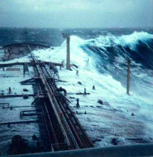
The origin and movement of waves reaching up to 11 metres that devastated France’s Reunion Island in the Indian Ocean on Saturday evening have been detected with ESA’s Envisat satellite.
The waves that thrashed the southern port of Saint Pierre, leaving two fishermen missing, causing several piers to collapse and flooding several homes and businesses, originated south of Cape Town, South Africa, and travelled northeast for nearly 4000 km over a period of three days before slamming into Reunion Island.
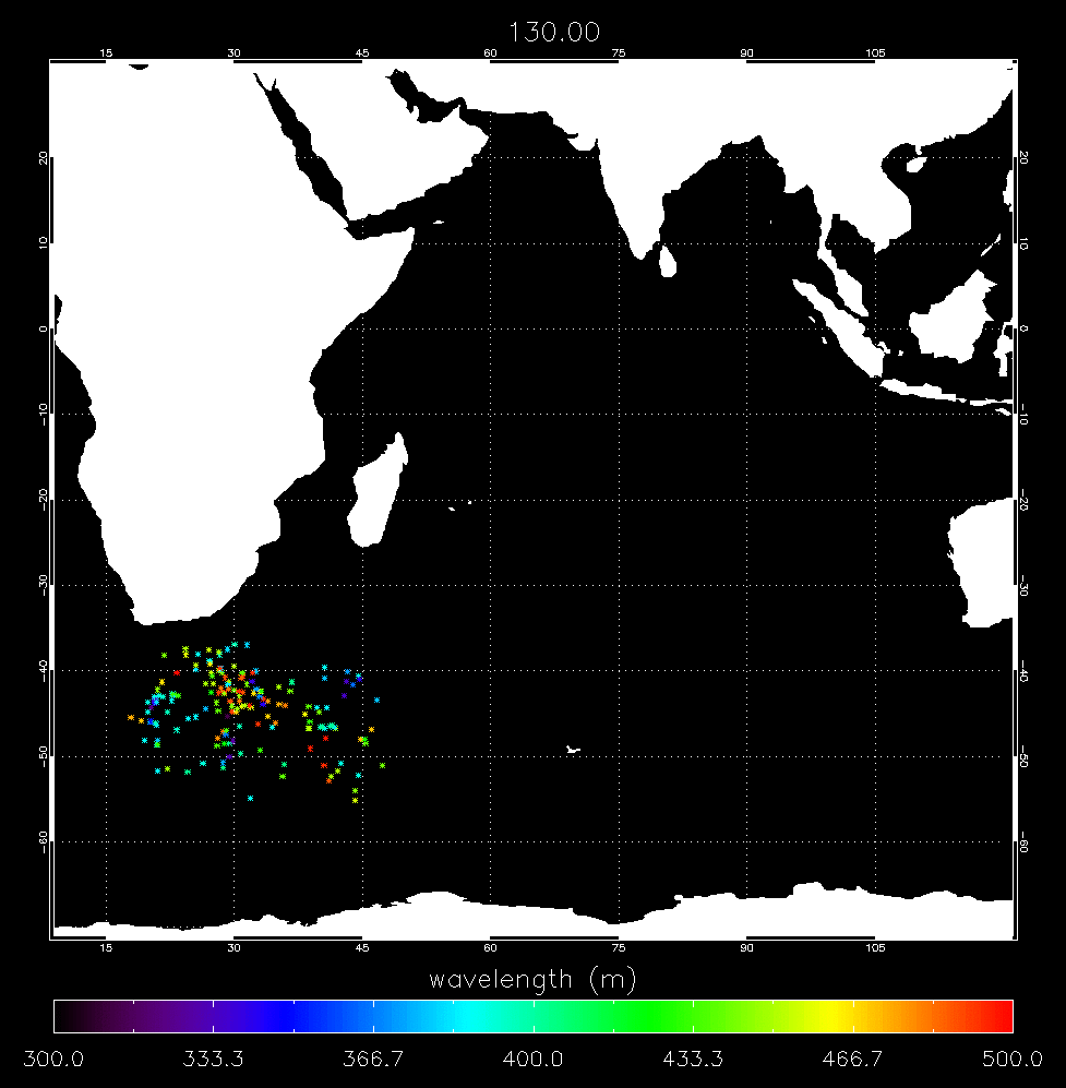
Dr Bertrand Chapron of IFREMER, the French Research Institute for Exploitation of the Sea, and Dr Fabrice Collard of France's BOOST Technologies in Brest located and tracked the swells using standard processed Synthetic Aperture Radar (SAR) ESA products.
"Swells are still surprise factors, which can unfortunately be deadly," Chapron said. "The SAR Wave Mode product allows us to locate and systematically track swells globally. In the near future we anticipate using SAR wave data to predict their arrival time and intensity."
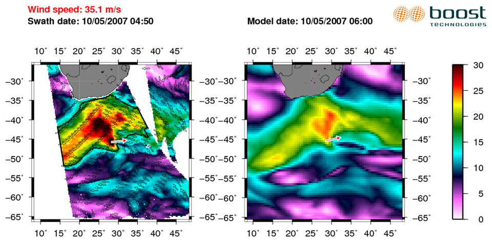
Although waves were forecast to hit Reunion Island, their intensity was predicted to be 20 to 30% below measurements, Collard explained.
"Because strong swells are preceded by calm water, it is impossible to detect their arrival from shore," Collard said. "SAR is the swell instrument and can typically observe swell periods in the range of 12 to 25 seconds."
A larger wave period correlates to a more extreme wind event. The one that hit Saint Pierre, Reunion Island, had a 19-second range and initially originated from very intense storm winds on 8 May.
Approaching the coastline, the wave system slows down and individual waves increase to reach at least two times the mean average of their initial wave height easily. For instance, a 5-metre significant wave height system can hit the coast with the height of 10 metres.
Chapron and Collard are working on a project that will make data for global swells available to scientists and users by the end of the year as a demonstration. The products will be useful for weather centres to complement the accuracy of their sea forecast models.
Swells are still surprise factors, which can unfortunately be deadly
Envisat is equipped with an advanced version of the SAR instrument, Advanced Synthetic Aperture Radar (ASAR), flown on the ERS-1 and ERS-2 missions. Its wave mode acquires 10 by 5 km small images, or 'imagettes', of the sea surface every 100 km along the satellite orbit. These small ‘imagettes’, which depict the individual wave heights, are then mathematically transformed into averaged-out breakdowns of wave energy and direction, called ocean-wave spectra, which ESA makes available to scientists and weather centres.
A typical SAR satellite images a swath of 400 km, enough to capture complete 'mesoscale' phenomena such as tropical storms. While optical satellite images show the swirling cloud-tops of a hurricane, a SAR image pierces through the clouds to show the sea surface roughness and its modulation through the combination of wind wave and currents.
Waves of all wavelengths and travelling in several directions are generated by storms. Upon leaving the storm, they disperse and those with the longest wavelengths travel the fastest. During the Envisat Symposium held in Montreux, Switzerland, from 23 to 27 April 2007, Chapron and Collard presented for the first time a demonstration of swell tracking across the Pacific Ocean over a period of 12 days using Envisat ASAR Wave Mode.
The same swell tracking was applied for the identification of the waves that hit Reunion Island last weekend. Independent satellite wind observations confirmed the position of the storm as the origin of the huge waves.
As part of the Global Monitoring for Environment and Security (GMES), a joint initiative of the European Commission and ESA, the space agency has undertaken the development of Sentinel-1, a European polar-orbiting satellite system for the continuation of SAR operational applications. The Sentinel-1 SAR instrument will have a dedicated wave mode allowing the Near Real Time tracking and forecasting of swell for European users.