Satélites de la ESA descubren olas monstruosas que hunden barcos
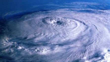
Olas gigantes alzándose a una altura de diez pisos han sido aceptadas como una causa central en el hundimiento de buques. Los resultados de los satélites ERS de la ESA han ayudado a determinar la existencia generalizada de estas feroces olas y ahora se utilizan para estudiar sus orígenes.
Durante las pasadas dos décadas, condiciones climatológicas adversas han hundido más de 200 superpetroleros y barcos mercantes de más de 200 metros de eslora. Se cree que las olas gigantes han sido la causa principal en muchos de esos casos.
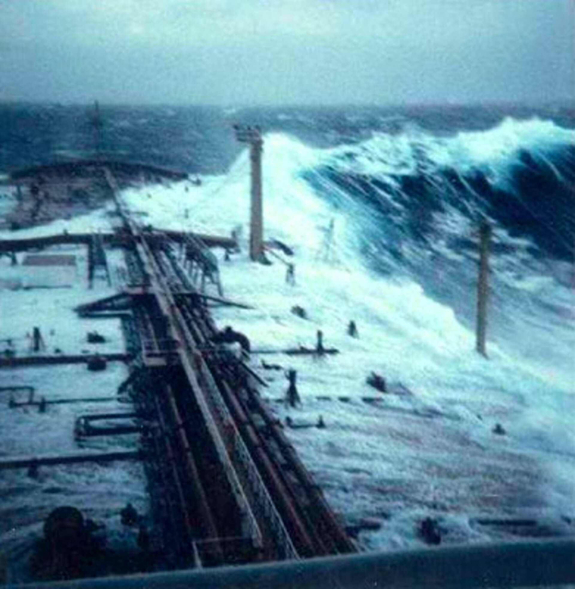
Los marineros que han sobrevivido a tales encuentros cuentan historias notables. En febrero de 1995 el trasatlántico Queen Elizabeth II se encontró con una ola gigante de 29 metros de alto durante un huracán en el Atlántico Norte, a la que el capitán Ronald Warwick describió como "una inmensa muralla de agua… parecía como si nos abalanzáramos hacia los acantilados White Cliffs de Dover".
Además, durante la semana entre febrero y marzo de 2001, – olas gigantes de 30 metros destrozaron las ventanas del puente a dos robustos cruceros turísticos –el Bremen y el Caledonian Star- en el Atlántico Sur. El primero quedó a la deriva sin navegación ni propulsión durante dos horas.

"Los incidentes se produjeron a menos de mil kilómetros de distancia entre sí", dijo Wolfgang Rosenthal –Científico Senior del centro de investigaciones GKSS Forschungszentrum GmbH, con sede en Geesthacht, Alemania– quien ha estudiado las olas gigantes durante años. "Toda la electrónica fue apagada en el Bremen mientras éste derivaba en paralelo a las olas, y hasta que se encendieron nuevamente, la tripulación pensaba que ese podría haber sido su último día de vida.
"El mismo fenómeno podría haber hundido navíos menos afortunados: en promedio, dos se hunden dos buques por semana, pero las razones nunca se estudian con el mismo detenimiento que un desastre aéreo. Sencillamente se lo atribuye al «mal tiempo»".
El fenómeno ha afectado también a las plataformas de alta mar: el 1 de enero de 1995 la torre perforadora Draupner, en el Mar del Norte, fue golpeada por una ola que medía, según un dispositivo láser de a bordo, 26 metros, y con olas alcanzando los 12 metros a su alrededor.

Pruebas objetivas logradas por radar en esta y otras plataformas –datos de radar delyacimiento petrolífero Goma, en el Mar del Norte, que registraron 466 choques de olas gigantescas en 12 años– ayudaron a convencer a científicos anteriormente escépticos, cuyas estadísticas mostraban que desviaciones tan notables del estado del mar circundante debieran producirse solamente una vez cada 10.000 años.
El hecho de que las olas gigantes, en realidad, se produzcan con relativa frecuencia tiene importantes implicaciones económicas y de seguridad, dado que los barcos y plataformas de altamar actuales están construidos para soportar únicamente olas con una altura máxima de 15 metros.
En diciembre de 2000, la Unión Europea inició un proyecto científico llamado MaxWave para confirmar la aparición generalizada de olas gigantes, realizar modelos de cómo se producen y considerar sus implicaciones en los criterios de diseño para las estructuras de barcos y plataformas de altamar. Y como parte de MaxWave, los datos de los satélites de radar ERS de la ESA fueron primeramente utilizados para efectuar un censo mundial de olas gigantes.

"Sin cobertura aérea de sensores de radar no teníamos posibilidades de encontrar nada", añadió Rosenthal, quien encabezó el proyecto de tres años MaxWave. "Todo lo que teníamos para avanzar eran los datos de radar recogidos de plataformas petroleras. Así que estábamos interesados en usar ERS desde el principio."
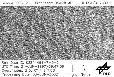
Los dos satélites gemelos de ESA, ERS 1 y 2 –lanzados en julio de 1991 y abril de 1995 respectivamente– tienen ambos un Radar de Apertura Sintética (SAR, por sus siglas en inglés) como instrumento principal.
El SAR trabaja en varias modalidades distintas; mientras está sobre el océano trabaja en modo de onda, adquiriendo "pequeñas imágenes" (imagettes) de 10 por 5 km de la superficie del mar cada 200 km.
Estas pequeñas imágenes son luego transformadas matemáticamente en desgloses promediados de la energía y dirección de las olas, llamados espectros de olas oceánicas. ESA pone estos espectros a disposición del público; ellos son útiles a los centros meteorológicos para mejorar la precisión de sus modelos de predicción marítima.
"No se distribuyen las pequeñas imágenes en bruto, pero con su resolución de diez metros nosotros creíamos que contenían una riqueza de información útil por sí mismas", dijo Rosenthal. "Los espectros de olas oceánicas ofrecen promedios del estado marítimo, pero las pequeñas imágenes representan las alturas individuales de las olas, incluyendo los extremos en que estábamos interesados.
"ESA nos suministró datos de tres semanas –alrededor de 30.000 pequeñas imágenes separadas– seleccionadas alrededor de la fecha en que fueron alcanzados el Bremen y el Caledonian Star. Las imágenes fueron procesadas y se las sometió a una búsqueda automática de olas extremas en el Centro Aeroespacial Alemán (DLR)".
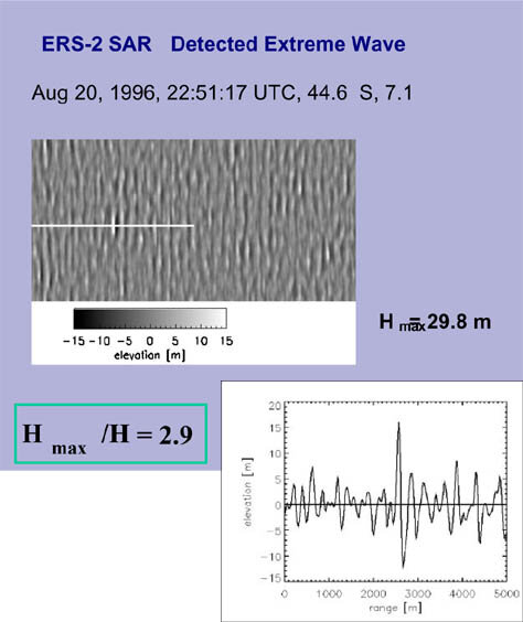
A pesar del tiempo relativamente breve que cubrían los datos, el equipo MaxWave identificó más de diez olas gigantes individuales en todo el globo, superiores a los 25 metros de altura.
"Tras haber probado su existencia, en mayor número de lo que nadie esperaba, el siguiente paso es analizar si pueden ser pronosticadas", añadió Rosenthal. "MaxWave concluyó formalmente, al final del año pasado, aunque actualmente dos líneas de trabajo se derivan de él: uno es mejorar el diseño de buques, comprendiendo cómo se hunden éstos, y la otra es examinar más datos procedentes de satélites con vistas a analizar si es posible realizar pronósticos".
Un nuevo proyecto de investigación llamado WaveAtlas utilizará dos años de imagettes de ERS para crear un atlas mundial de olas gigantes y efectuar análisis estadísticos. La investigadora principal es Susanne Lehner, profesora adjunta de la División de Física Marina Aplicada de la Universidad de Miami, quien también trabajó en MaxWave mientras estaba en DLR, y Rosenthal será un co-investigador del proyecto.
"Examinar las pequeñas imágenes da una sensación como de volar, porque uno sigue el estado del mar bajo el curso del satélite", dijo Lehner. "También se ven en ellas otras cosas como desprendimientos de hielo, manchas de petróleo y hasta barcos, y por eso hay interés en usarlas para otras áreas de estudio.
"Sólo los satélites de radar pueden ofrecer datos verdaderamente globales para el análisis estadístico de los océanos, porque pueden ver a través de las nubes y de la oscuridad, a diferencia de sus contrapartidas ópticas. En tiempo tormentoso, las imágenes de radar son, por lo tanto, la única información pertinente disponible".
Ya se han encontrado algunos patrones. Las olas gigantes suelen estar vinculadas con sitios donde las olas comunes se encuentran con corrientes y remolinos oceánicos. La fuerza de la corriente concentra la energía de la ola, formando olas mayores; Lehner la compara a una lente óptica, que concentra la energía lumínica en un área pequeña.
Esto es especialmente cierto en el caso de la notablemente peligrosa corriente de Agulhas, en la costa oriental de Sudáfrica, pero también pueden encontrarse olas gigantes vinculadas a otras corrientes como la Corriente del Golfo en el Atlántico Norte, en interacción con las olas que bajan del mar de Labrador.
Sin embargo, la información muestra que las olas gigantes también pueden producirse lejos de las corrientes, a menudo en la vecindad de frentes atmosféricos de alta o baja presión. Los vientos sostenidos de tormentas prolongadas, de más de 12 horas pueden amplificar las olas que se mueven a una velocidad óptima en sincronismo con el viento: si van demasiado rápidamente se adelantan a la tormenta y se disipan; si van demasiado lentamente, se quedan retrasadas.
"Conocemos algunas de las razones para las olas gigantes, pero no las sabemos todas", concluyó Rosenthal. El proyecto WaveAtlas está programado para continuar hasta el primer trimestre de 2005.