
Earth from Space: Patagonia
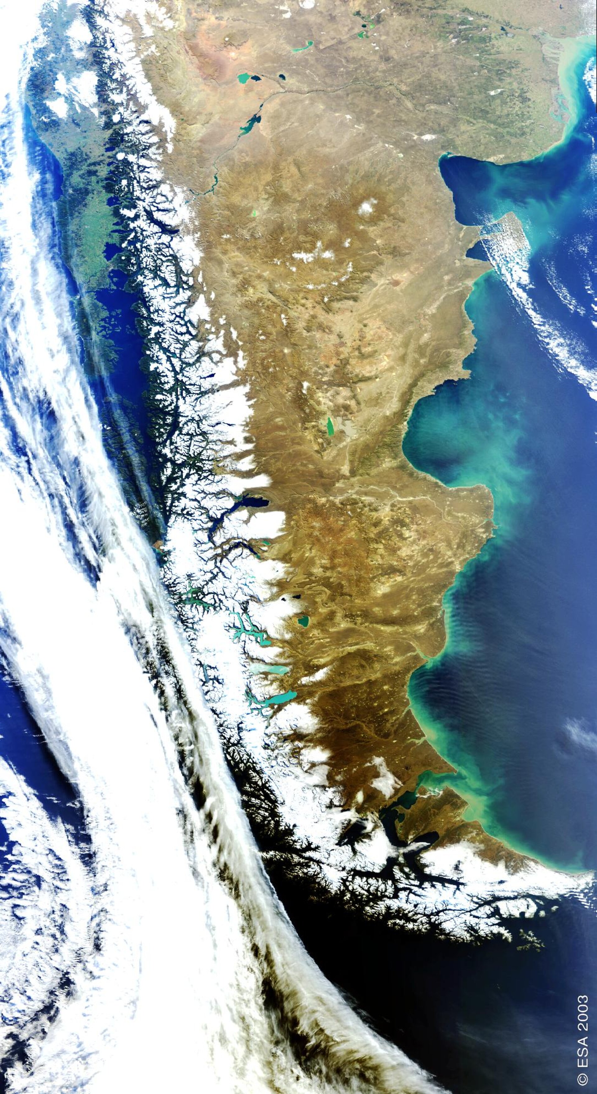
This Envisat image is focused over the Patagonia Plateau in Argentina and southern Chile, and shows the snow-capped Andes mountain range which forms a natural boundary between the two countries.
The Andes - the longest system of high mountain ranges and the second highest peaks on Earth - are responsible for the high contrast in landscape between Argentina and Chile.
The top left hand corner of the image highlights the mostly green and lush landscape of Chile due to its cool, damp southern climate, while Argentina appears brown and dry due to its arid (southeast) and subantarctic (southwest) climates.
Patagonia, the southern part of Argentina, extends from the Atlantic Ocean on the east to the foothills of the Andes on the west. It is the largest desert in the Americas and consists primarily of arid and desolate steppes.
The island archipelago of Tierra del Fuego, located at the southern tip of Patagonia (the southernmost tip of the image), is shared by Argentina and Chile, with the eastern part of the main island belonging to Argentina and the southern point of the archipelago, which forms Cape Horn, belonging to Chile.
Ferdinand Magellan discovered the archipelago in 1520 and named the islands Tierra del Fuego, ‘Land of Fire’, because of the many fires he saw on the beaches used by the aborigines to keep warm (the average yearly temperature is 6°C) and for cooking.
These islands located in the ocean current circling Antarctica have some of the worst weather in the world, continuously battered by high winds and covered by clouds.
The Strait of Magellan, named after the discoverer, lies between Tierra del Fuego and mainland Argentina.
Along the Atlantic coast, from top to bottom in the image, Bahia Blanca, the Gulf of San Matias, the Valdes Peninsula, the Gulf of San Jorge, Cape Tres Puntas (in the centre) and the Grande Bay can be seen.
The tan-green colour in the Bahia Blanca is due to sediments deposited in the water by the Colorado and Negro rivers, while the bright turquoise lakes seen in the image are the result of extremely fine sediment deposited by glaciers.
Acquired by ESA’s Envisat’s Medium Resolution Imaging Spectrometer (MERIS) on 28 August 2003, this image has a pixel sampling of 1200 metres and a width of 1300 kilometres.

