ESA participating in UN's Montreal summit working for a better atmosphere
Delegations from 190 nations will attend next week's United Nations summit in Montreal, Canada, to begin negotiating a post-Kyoto Protocol strategy to restrict emissions of heat-trapping gases that drive climate change. Joining them will be ESA, to share results from satellite-based services developed to support the Protocol.
More than 10 000 representatives of national governments, international organisations and non-governmental organisations are expected at the first meeting of the Parties to the Kyoto Protocol (COP/MOP 1), held in conjunction with the eleventh session of the Conference of the Parties (COP 11) to the United Nations Framework Convention on Climate Change (UNFCCC). This joint summit takes place in Montreal's Palais des Congrès from 28 November to 9 December.
ESA will be manning an exhibit throughout this historic summit to communicate its own Kyoto-supporting services, and is jointly hosting a special side event together with national partner end-users.
This is the first COP since the Kyoto Protocol to the UNFCCC entered into force in 16 February 2005. The Protocol commits its signatories to reduce levels of greenhouse gases – chief among them carbon dioxide – believed to be increasing global warming.
Around 25 billion tonnes of extra carbon dioxide is released into the atmosphere annually by human activities, mainly through wildfires, land clearance and the burning of fossil fuels. The total amount of carbon dioxide in the atmosphere has increased by a quarter since the start of the Industrial Revolution 150 years ago.
Developed countries in general are required to reduce their greenhouse gas emissions by 5% compared to reference year 1990 between 2008 and 2012, with the European Union committed to a reduction of 8%. One of the main goals of this summit is to agree methods and targets for emissions reductions beyond 2012, when the first phase of the Protocol runs out.
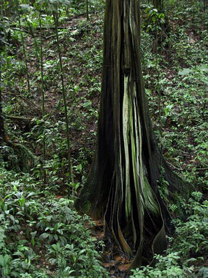
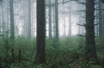
However there is another way as well as reducing greenhouse gas emissions to clear the air of excess carbon dioxide, and the Kyoto Protocol takes account of this. Plant growth absorbs carbon from the atmosphere, so the Protocol includes a mechanism for signatories to offset emissions against increases in the stock of carbon stored in vegetation, especially forests.

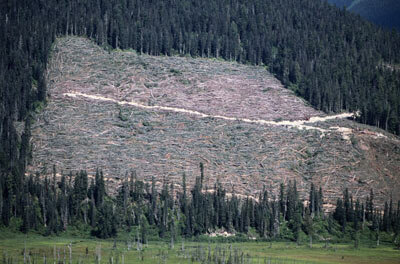
What the Protocol requires for such offsetting to take place is annual reporting of land use changes – especially afforestation, reforestation and deforestation (ARD) - associated with shifts in the terrestrial carbon stock, to be carried out at the national level.
This is where ESA comes in: the Agency has a long-standing commitment to extend the use of satellite data beyond science into operational applications, and in particular to strengthen the effectiveness of international conventions. So work began on the Kyoto Inventory service for land cover mapping back in November 2002, well before the Kyoto Protocol had been ratified.
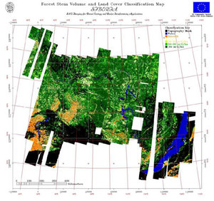
The work being supported through the Agency's Data User Programme, imagery from satellites including ERS, Landsat, Proba and SPOT were utilised to produce forest maps, land use and land use change maps covering 1990, 1997 and 2002 across 200 234 square kilometres of European territory, working with national end-users responsible for Kyoto reporting in Italy, the Netherlands, Spain and Switzerland.

This three-year project has just concluded, but the work continues, and is being scaled up, within a new project called GSE Forest Monitoring, whose consolidation phase began in October.
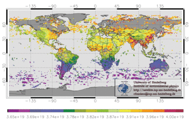
This fully operational forest and land use monitoring service has extended its European core users to Austria, Denmark, Finland, France, Germany, Greece, Latvia, Poland, Russia and Sweden – as well as offering pan-continental coverage to the European Environmental Agency. Beyond Europe, the service is working with countries including Indonesia, Namibia and South Africa, and includes the evaluation of Kyoto-authorised Clean Development Mechanism (CDM) afforestation to foster inward investment and sustainable development in developing countries.
GSE Forest Monitoring is being carried out as part of the initial portfolio of services offered through Global Monitoring for Environment and Security (GMES), a joint initiative between ESA and the European Commission (EC) to build a global monitoring capability in support of Europe's environmental and sustainable development goals.
As well as maintaining an exhibit throughout the COP to communicate Kyoto Inventory and Forest Monitoring activities, ESA will also be presenting a demonstrator on GMES projects with the EC.
On 29 November Stephen Briggs, Head of ESA's Earth Observation Science and Applications Department has been invited by organisers to give one in a series of Climate Talks to be webcast from the UNFCCC COP 11 website, on the subject of 'How the climate benefits from space' (available via the right navigation bar link).
The dedicated ESA side event takes place on the evening of the following day in the Churchill River Room of the Congres, with national end users of both projects participating to present results. In addition ESA will be participating in a Canadian Space Agency thematic day at the Canadian pavilion on 8 December.