Express map delivery from space
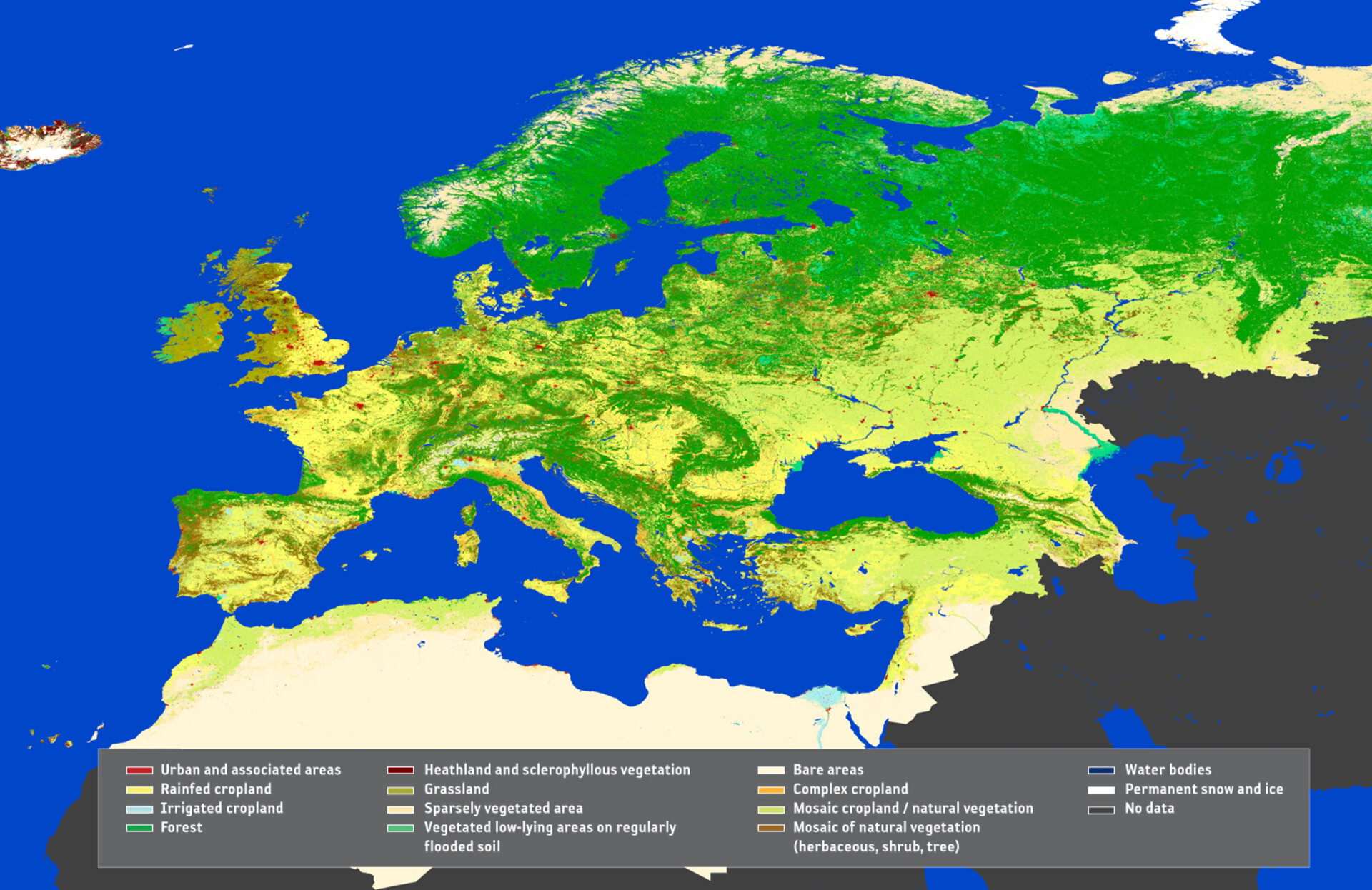
Meeting the environmental needs of an ever-expanding Europe requires consistent and regularly updated information on its land cover and use. As part of ESA’s GlobCorine project, a pan-European land cover and use map for 2009 is now available online.
The map, based on ESA’s Envisat MERIS data from 1 January to 31 December 2009, is the first of its kind to be produced in such a short time – nine months as opposed to years.
GlobCorine shows how an automated service can generate and regularly update such maps, which are essential for environmental agencies.
The map, providing a resolution of 300 m, was delivered to the European Environmental Agency (EEA), the project’s main user, in October.
"The novelty of this map is that we can finally have relevant, timely global land cover information compatible with the time series of European Corine land cover data for decision-making," EEA’s Chris Steenmans, Head of Programme, Shared Environmental Information System, said at the final GlobCorine meeting held at ESA’s Earth observation centre (ESRIN) in Frascati, Italy, last week.
"If you want to bring the environment into the context of economic and social development, then the speed of environmental information delivery needs to keep pace with economists and decision-makers for sustainable development.
"This means we can’t continue what we have done in the past, which was to report on land use changes using three or sometimes five-year-old data. Instead, we have to provide up-to-date figures that will help us to monitor sustainability of our ecosystem services."
Jean-Louis Weber, Special Adviser on Economic Environmental Accounting at EEA, said the idea of GlobCorine is based on two needs: "EEA has been asked by the European Commission to organise an information and reporting system on the state of the environment for the whole pan-European and Mediterranean region, and land cover is basic information needed to understand more complex processes.
"EEA is also involved in 'green accounting' in the UN context where we cooperate with the World Bank for ecosystem evaluation methodologies. Recently, a Global Partnership for Ecosystem Valuation has been organised by the World Bank.
"Before monetary evaluation can begin, one must describe the ecosystems and how they change. The GlobCorine map is a precursor that can be used to organise this type of information and accounting."
Sophie Bontemps of the Université catholique de Louvain in Belgium, which carried out GlobCorine with ESA, said she was pleased to work in close collaboration with EEA because it allowed her to obtain a clear view of the usefulness of the project.
"GlobCorine is much more than a project aiming to deliver a European land cover map. It is the scientific and technical demonstration that a description of the state of land surface on a continental scale can be provided within a year."
GlobCover is an excellent example of a successful inter-agency partnership