
The island of Luzon with its capital Manila has been struck by two major disasters already this decade: the earthquake in July 1990 and the eruption of Mount Pinatubo in June 1991. The volcanic event in particular is still on people's minds, as every year, during the season of tropical rain storms, the pyroclastic material accumulated on the flanks of the mountain is flushed down towards the rich agricultural land, covering it with metres of fine ash. Lahars are also visible on spaceborne SAR images, like those from the ERS satellites that provide a weather- independent monitoring tool.
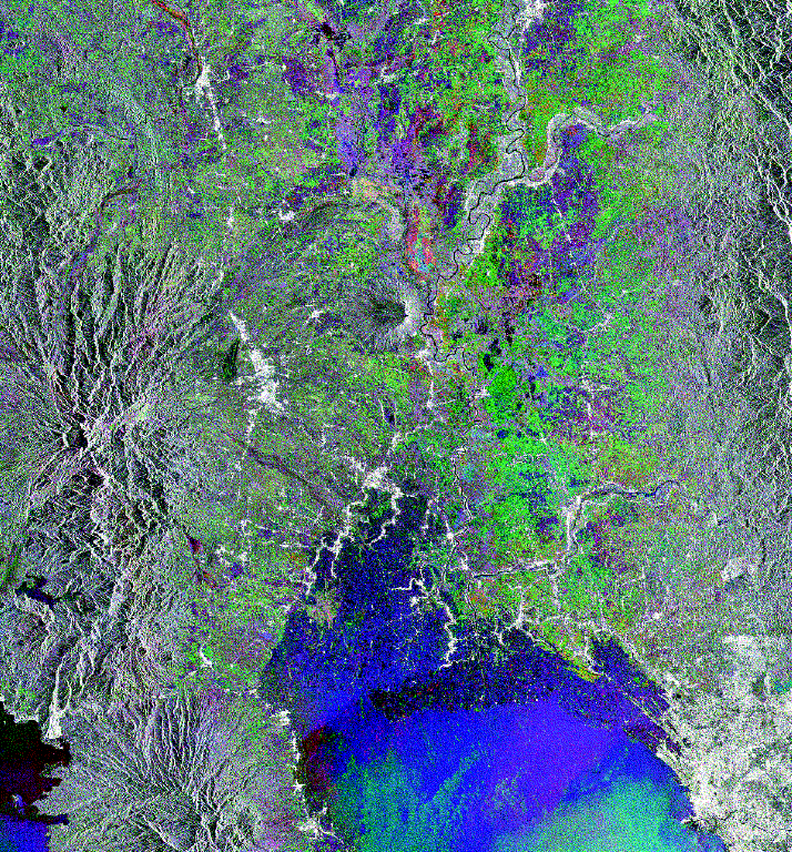
The ERS-1 SAR image shown here is a composite of three acquisitions during 1993: 25 July displayed in green, 29 August displayed in red and 3 October displayed in blue. The most colourful part of the image is the plain of Pampanga Province, with the volcanic cone of Mount Arayat in the centre. In the right lower corner, a part of the city of Manila is visible. To the right , one can see hills consisting of tertiary sediment, whilst all mountains to the left are of volcanic origin. Pinatubo is situated to the left, close to the edge of the image; its crater, containing a small lake, is typical. Built-up areas are clearly visible throughout as bright patches, and they also stretch along the main interconnecting roads.
Different colours in the plain indicate different crops: rice fields appear in dark green, sugar cane in green-yellowish hues, and swamp areas in magenta. Just above the volcanic cone of Mount Arayat, patches of intense red, yellow and blue tones are visible: these are plantations of water melons and sugar cane. The large river bed close to this zone appears bright in the image because of the high density of small corrugated-iron-roofed houses built in a zone of fruit-tree orchards.
Although only the eastern slopes of Pinatubo are visible, major land destruction occurred in the valleys and in the coastal plain towards the South China Sea. All rivers originating from the hills surrounding the volcano show enlarged dark-magenta river beds. This is evidence of the presence of mud flows (lahars) that, on their way to the sea, destroyed bridges and power lines, covering the soil with a several-metre-thick layer of white mud. In particular, the northerly running O'Donnell River shows these characteristics. But the other rivers also, such as the Sacobia River which destroyed the USA's Clark Air Base, are clearly discernible to the left of the image's centre. Further down are the Pasig River (see also Fig. 4) and the Gum Ain River (Figs.1 and 2), both of which are also affected by lahars.
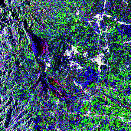
Figure 1. Image section near the town of San Jose with the Basa
Air Base (lower left in the overview image). The large dark and
coloured areas are lahars of 1991 reactivated during the 1993
rainy season. However, the deposits in the prolongation of the
runways appear much wider with respect to 1991.
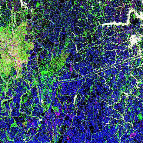
Figure 2. Shrimp farms near the shore in Manila Bay. The very
fine network of ponds including the many isolated houses and
small settlements are sharply imaged with the ERS SAR. Near the
inlet of the Gum Ain River (right), the damage caused to a large
number of ponds by the mud flows is evident and the fragile
separation dams have disappeared.

Figure 3. A Bacolor taxi-driver desperately digs out his only
resource. Some palm trees seem to have survived in the several-
metre-deep lahar deposit (photo taken in April 1996).

Figure 4. In 1995 the town of Bacolor was hit by a lahar directed
by the Pasig River bed. All of the houses, including the church,
were partially or fully engulfed by the mud. In the background,
one can see already repaired power lines (photo taken in April
1996).
If one compares the survey map made in 1991 by the Philippine Institute of Volcanology and Seismology with the ERS images of 1993, the changes that have occurred from one year to the other are remarkable. The ERS SAR picks them up easily thanks to its frequent revisit cycle.
The contribution of Dr. Giovanni Rantucci, who made available his report 'Geological Disasters in the Philippines', as well as maps that were used to refine the image interpretation, is gratefully acknowledged.


 ESA Bulletin Nr. 89.