Floods
In some countries serious flooding is almost an annual event, damaging housing, roads and agriculture and causing loss of lives, sometimes in the thousands. Bangladesh, Somalia and Honduras have been severely hit in recent years, as has Europe, where Italy, France, Germany and Britain - among others - are regularly affected by severe flooding.
One of the biggest problems is obtaining an overall view of the flooding in order to have a clear idea of the extent of the flooded area and to predict likely developments. Rapid identification of areas at risk and a quick response is vital, and can prevent floods turning into a major disaster. In Somalia, after three consecutive years of flooding which have destroyed housing, roads and buildings, and badly damaged crops and agricultural land, an estimated 170 000 people are still in need of food aid.
In Europe alone, 85% of civil protection measures deal with floods. This gives some idea of the economic importance of the real-time data supplied by Envisat, apart from the benefits it will bring to those living in areas at risk. What is more, the amount of damage caused by flooding is set to increase. This is partly due to extensive building close to river banks, reducing the amount of land where flood waters can drain away, and partly due to global warming, which may increase the number of climate-related disasters.
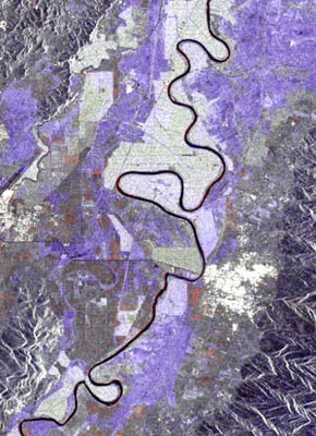
In the case of plain flooding, damage maps can be produced rapidly by combining new images and reference data acquired using the all-weather ASAR sensor on board Envisat. Thanks to the steering beam capability of ASAR, it generally takes little time to access and acquire data on flooded areas thus allowing rapid damage assessment.
Time series of ASAR-based image maps can show exactly how far flooding has spread and help to identify the areas at highest risk so that civil protection teams can concentrate their efforts in these areas. In addition, geo-information systems, based on both ASAR-derived damage maps and optical-based land cover maps, enables the identification and location of the different thematic features affected by floods, such as housing, roads and other infrastructure.