Applications
Above-ground biomass 2022
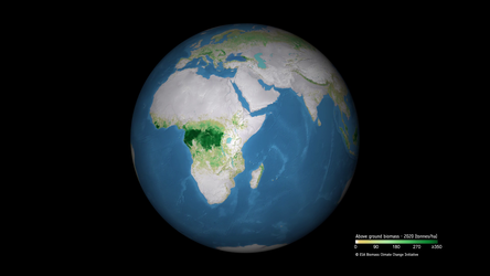
ESA has released its most extensive satellite-based maps of above-ground forest carbon to date. Spanning nearly two decades, the dataset offers the clearest global picture yet of how forest carbon stocks have changed over time. Developed through ESA’s Climate Change Initiative Biomass project, this new long-term record integrates data from multiple satellite missions. The image shows the distribution and density of above-ground biomass in 2022.
Read full story: ESA unveils longest-ever dataset on forest biomass