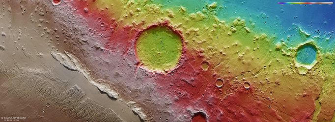
Topography of Acheron Fossae’s western edge
This colour-coded topographic image shows the Acheron Fossae region of Mars.
It was created from data collected by ESA’s Mars Express on 24 October 2024 (orbit 26273) and is based on a digital terrain model of the region, from which the topography of the landscape can be derived. Lower parts of the surface are shown in blues and purples, while higher altitude regions show up in whites and reds, as indicated on the scale to the top right.
North is to the right. The ground resolution is approximately 16 m/pixel and the image is centred at about 37°N/220°E.
ALT-text: A topographical map of the Acheron Fossae region of Mars, as seen by ESA’s Mars Express
Image description: A colour-coded topographic map of Acheron Fossae’s western edge. Elevation is indicated by a gradient from red and white (high ground) to blue and purple (low ground). The image reveals the transition from high-lying plains on the left, to deep valleys centre-right, to knobby terrain followed by lowland plains on the right. North is to the right. Some impact craters and ridges can also be seen.