Antarctic Peninsula by Sentinel-1D
This image is one of the first to be captured by the Copernicus Sentinel-1D satellite, which carries a 12 m-long synthetic aperture radar (SAR) instrument. It was captured on the night of 6 November (European time) and the data was then transmitted from the satellite to the Matera ground station, in Italy. All this was done within 50 hours of launch, which is likely to be the shortest time from launch to data delivery for a radar-based Earth observation satellite.
Radar instruments are particularly useful for imaging Earth’s surface through rain and cloud, as well as in darkness, making radar an ideal remote-sensing tool for observing polar regions. The satellite also carries an Automatic Identification System (AIS) instrument – enabling the mission to improve detection and tracking of ships over maritime zones.
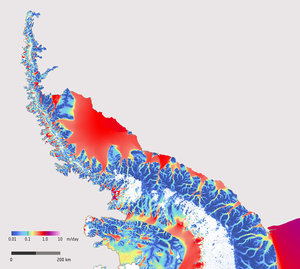
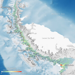
The Antarctic Peninsula, which is part of the larger peninsula of West Antarctica, protrudes 1300 km. It is an ice sheet resting on a string of rocky islands and its tip is just 1000 km from the southern tip of South America. The Antarctic Peninsula ice sheet is one of the smallest ice sheets in Antarctica but is perhaps the most vulnerable to climate change as its glaciers are small and in a region of rapid warming. Observable changes such as collapsing ice shelves, thinning and accelerating glaciers are all key indicators of climate change in the region.
This image is in black and white, showing the contrast between the ocean and the peninsula’s icy landscape. The black and white represents the intensity of the radar signals that reflect off Earth’s surface – known as ‘backscatter’. Surfaces such as ice and snow reflect stronger radar signals, represented by brighter pixels in the image. Darker pixels denote lower-intensity backscatter, which is created when the radar signal reflects off a specular surface – in this case the surface of the Southern Ocean.
Read full story: Sentinel-1D delivers first images: from Antarctica to Bremen