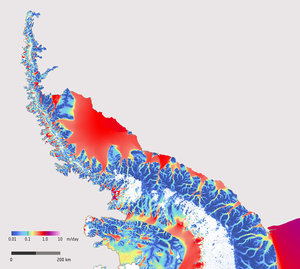
Ice velocity on Greenland ice sheet, 2014–2024
This map, based on Copernicus Sentinel-1 data, shows the speed at which ice is moving horizontally on the Greenland Ice Sheet. Sentinel-1’s year-round acquisitions of the ice sheet's marginal zones, along with dedicated winter mapping campaigns that include the interior ice sheet, enable the production of annual ice sheet-wide velocity maps. These maps are derived using offset tracking, a data analysis technique that compares satellite images of the same location at different times to ‘track’ ground movement.
The study shows rapid flow of ice, moving at average speeds of up to 15 m per day, from glaciers and ice sheets at points around the Greenland Ice Sheet. Half-way up the western coast of Greenland, Sermeq Kujalleq (also known as the Jakobshavn Glacier), is one of the fastest outlet glaciers in the world with velocities reaching, at times, up to 50 m per day. The North-East Greenland Ice Stream (NEGIS), is also clearly visible and begins far inland at the ‘ice divide’, shown as a dark blue band of nearly stagnant ice in Greenland’s interior.
Further detail, as marked on the map, is viewable here.
Read full story: Sentinel-1 provides essential data over shifting ice sheets