Topographic map of Shalbatana Vallis on Mars
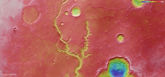
This colour-coded topographic image shows part of Shalbatana Vallis, a large channel near Mars’s equator.
It was created from data collected by ESA’s Mars Express on 22 October 2024 (orbit 26265) and is based on a digital terrain model of the region, from which the topography of the landscape can be derived. Lower parts of the surface are shown in blues and greens, while higher altitude regions show up in whites and reds, as indicated on the scale to the top right.
North is to the right. The ground resolution of the original image is approximately 22 m/pixel and the image is centred at about 12°N/317°E.
[Image description: A brightly coloured patch of Mars, with a large, winding channel running from the bottom left to the right of the frame. The rest of the landscape is scattered with circular craters and uneven bumps, but is mostly smooth. A colour scale bar indicates that blue-green colours are lowest altitude, red-white-brown colours are highest altitude, and yellow-orange are in the middle.]

Where on Mars is Shalbatana Vallis?

Mars’s Shalbatana Vallis in 3D

A view from above: Shalbatana Vallis on Mars

Mars Express visits Shalbatana Vallis on Mars