Applications
El Niño 2026 begins
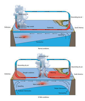
Satellite measurements are showing a sharp surge in sea-surface temperatures across the tropical Pacific in recent months – the clearest early signal that El Niño is back. This powerful climate pattern, and its counterpart La Niña, can supercharge weather worldwide, amplifying extremes from heatwaves and droughts to torrential rainfall, floods and disrupted winter storm tracks, all on top of the effects of the already warming climate driven by human activity.
The image shows early signals of the developing event, highlighting sea-surface temperature anomalies from 1–7 June 2026 compared to the 1991–2020 average for the same period.
See full animation.
Read full story: Pacific warming signals El Niño has stirred