Applications
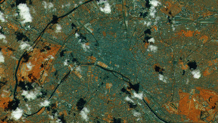
View of Paris: Satellite vs. Tessera embedding
Tessera, an advanced artificial intelligence (AI) model, offers high-accuracy datasets that encode what the satellite ‘sees’ of Earth’s surface during the course of a year. This compressed data can be used by the scientific community to generate information-rich maps.
Crucially, the encoded datasets – embeddings – use far less data than the pixellated images that are downlinked from satellites. A variety of applications are supported by the model, from monitoring agricultural crops, to measuring forest canopies and detecting wildfires.
This image shows a satellite view of Paris, France, compared to one of Tessera’s ‘embeddings’.
Read full story: Tessera AI model offers accessible way to view Earth