ESA
Education
Hauptseite
Wetter und Klima
Globale Veränderungen
Naturkatastrophen
Erdbeben
Einführung
Das Erdbeben von Izmit
Hurrikane
Sturmfluten
Hurrikan Katrina
Überschwemmungen
Thessaloniki (Griechenland)
Vulkane
Einführung
Anden-Vulkangürtel
Ätna
Nyiragongo und Nyamuragira
Suche
Article Images
Übung 2: Visualisierung und Untersuchung der infolge von Katrina überfluteten Bereiche von New Orleans - Fortsetzung
Zurück zum Artikel
Download:
HI-RES JPEG
(Size:
57 kb
)
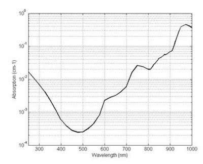
Absorption of water with respect to the wavelength of the incident radiation.
Credits: Zhun310, http://en.wikipedia.org/wiki/File:Figure_2_The_absorption_spectrum_of_water.jpg
Sturmfluten
Einführung
Hurrikan Katrina
Einführung
Übungen
Übung 1: Der Hurrikanwirbel Katrina von der Wolkenoberseite bis hinunter zur Meeresoberfläche
Übung 2: Visualisierung und Untersuchung der infolge von Katrina überfluteten Bereiche von New Orleans
Eduspace - Software
LEOWorks 3
Eduspace - Download
Envisat and SPOT data (zip)
Related links
Hurricane Katrina - NOAA
Hurricane Katrina - Wikipedia
National Hurricane Center - NOAA
Storm surge overview - NOAA
Global Monitoring for Environment and Security - ESA
International Charter Space and Major Disasters
Tropical weather and hurricanes - Physicalgeography
Related news
Envisat sees whirling Hurricane Katrina from ocean waves to cloud tops
Related videos
Cyclone Floyd - 9 September 1999
(0.7 Mb)
Cyclone Floyd - 13 September 1999
(1.5 Mb)
Cyclone Floyd - 14 September 1999
(1.6 Mb)
Cyclone Floyd - 15-16 September 1999
(3.4 Mb)
Copyright 2000 - 2014 © European Space Agency. All rights reserved.