ESA
Education
Home
Weather and Climate
Global Change
Natural Disasters
Earthquakes
Introduction
Izmit earthquake
Floods
Thessaloniki (Greece)
Hurricanes
Storm surges
Hurricane Katrina
Volcanoes
Introduction
Andean Volcanic Belt
Etna
Nyiragongo and Nyamuragira
Search
Article Images
Exercise 2: Visualising and examining flooded areas in New Orleans caused by Hurricane Katrina - continued
Back to article
Download:
HI-RES JPEG
(Size:
57 kb
)
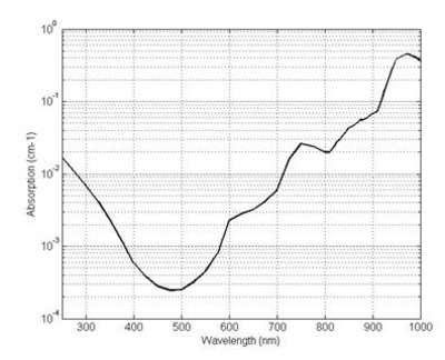
Absorption of water with respect to the wavelength of the incident radiation.
Credits: Zhun310, http://en.wikipedia.org/wiki/File:Figure_2_The_absorption_spectrum_of_water.jpg
Storm surges
Introduction
Hurricane Katrina
Introduction
Exercises
Exercise 1: Spiraling Hurricane Katrina from cloud tops to ocean waves
Exercise 2: Visualising and examining flooded areas in New Orleans caused by Hurricane Katrina
Eduspace - Software
LEOWorks 3
Eduspace - Download
Envisat and SPOT data (zip)
Related links
Hurricane Katrina - NOAA
Hurricane Katrina - Wikipedia
National Hurricane Center - NOAA
Storm surge overview - NOAA
Global Monitoring for Environment and Security - ESA
International Charter Space and Major Disasters
Tropical weather and hurricanes - Physicalgeography
Related news
Envisat sees whirling Hurricane Katrina from ocean waves to cloud tops
Related videos
Cyclone Floyd - 9 September 1999
(0.7 Mb)
Cyclone Floyd - 13 September 1999
(1.5 Mb)
Cyclone Floyd - 14 September 1999
(1.6 Mb)
Cyclone Floyd - 15-16 September 1999
(3.4 Mb)
Copyright 2000 - 2014 © European Space Agency. All rights reserved.