| | | | |
 |
|
Coastal change Danube Delta change detectionOil spillsDeforestation Bardia National ParkCongo River BasinKameng-Sonitpur Elephant ReserveKilimanjaroRondoniaShillong and GuwahatiIce Antarctica 2003Climate change and glaciersGlacier analysis using radar imageryGlacial retreat in the AlpsGlacier Ice FlowMonitoring of glaciers in the HimalayasRemote sensing of ice and snowUrbanisation CairoCity of KathmanduCórdobaHimalayasKathmandu ValleyLagosVegetation Annapurna Conservation AreaLost in the AndesNgorongoro Conservation AreaNiger Inland DeltaVegetation in South America
| | | | | | | Guwahati
This excercise requires the use of LEOWorks.
Detection of changes in a city's land use over time
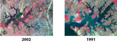
Change detection in the Guwahati area.
Let's move on to another set of images with a slightly longer time span between them, and hence, a greater amount of differences to spot, for both you and the LEOWorks software!
Download the files 'Guwahati _1991.tif.zip' and 'Guwahati _2002.tif.zip'. From each year there are images from band 1 to band 6.
Open the 2 image files of Guwahati city of the years 1991 and 2002.
From the Select Channels window, choose RGB and select, for the 1991 image, to construct a colour image:
- Ghy_26nov91.tif:channel4 for the colour R
- Ghy_26nov91.tif:channel3 for the colour G
- Ghy_26nov91.tif:channel2 for the colour B
Do the same for the 2002 image.
1. Visually inspect the images and try to spot obvious differences.
In the lower left corner of both images lies a large wetland called the Dipor Beel. The wetlands are very important for a city’s health, as they act as cooling machines, somewhat akin to an extra large air conditioner. They not only help recharge groundwater levels that help supply water to a city’s growing urban dwellers (Guwahati currently has an excess of 1 million residents), but also moderate micro climates and reduce urban heat island effects. Ask your geography teacher at school to tell you what urban heat islands are, or look it up in an encyclopedia!
The Depor Beel was recognised as a Ramsar site, and is a wetland of international importance.
Incidentally, wetlands attract thousands of migratory birds from as far away as Siberia during their long migration routes.
If you look at the two images, you can see that the wetland has lost a good chunk of its areal extent, and with this naturally its overall health as well. This is certainly not a good thing for the city of Guwahati in the years to come.
Various human activities have encroached on the wetlands, such as brick factories, urban structures (housing and otherwise), and have resulted in the shrinkage of the wetland area.
Can you measure how much of the wetland’s area has been lost during the period from 1991 to 2002?
Go to Image>Measure>Convert Units to metres. Click on two points of the Dipor Beel on the 2002 image. Repeat this for the 1991 image.
2. How much of the length of the wetland has been reduced? Click on two points of the wetland; then right click to free the tool. Consult the Measurement Tool - it will give you an answer in metres.
Even the dendretic drainage (a sort of tributary area of the wetland) has decreased:
Examine the images more closely.
3. Has the areal extent of the Dipor Beel really reduced?
The answer is both yes and no. Surprised? Don’t be, because if you have a degree of familiarity with the area, it will be obvious that while the area has decreased, at the same time some aquatic growth seems to have overrun parts of the wetland, so it's quite difficult to gauge exactly how much of the wetland’s area has been lost. In addition, human activity has also crept in. Familiarity with an area is therefore needed, beyond the study of an area’s satellite images.
| |
| | Shillong and Guwahati IntroductionShillongGuwahatiExercises IntroductionOverviewShillongLinks Useful linksEduspace - Software LEOWorks 3ArcExplorerEduspace - Download Guwahati_1991.tif.zipGuwahati_2002.tif.zipShillong_1999.tif.zipShillong_2004.tif.zip
|