ESA
Education
Home
Weather and Climate
Global Change
Natural Disasters
Coastal change
Danube Delta change detection
Oil spills
Deforestation
Bardia National Park
Congo River Basin
Kameng-Sonitpur Elephant Reserve
Kilimanjaro
Rondonia
Shillong and Guwahati
Ice
Antarctica 2003
Climate change and glaciers
Glacier analysis using radar imagery
Glacial retreat in the Alps
Glacier Ice Flow
Monitoring of glaciers in the Himalayas
Remote sensing of ice and snow
Urbanisation
Cairo
City of Kathmandu
Córdoba
Himalayas
Kathmandu Valley
Lagos
Vegetation
Annapurna Conservation Area
Lost in the Andes
Ngorongoro Conservation Area
Niger Inland Delta
Vegetation in South America
Search
Article Images
Background
Back to article
Download:
HI-RES GIF
(Size:
729 kb
)
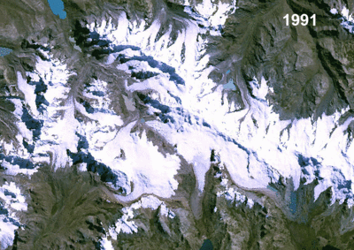
Landsat satellite images showing retreating glaciers in the Andes of Peru, South America. (See GoogleEarth file location 3.8)
Credits: Landsat
Back to article
Download:
HI-RES GIF
(Size:
129 kb
)
Model of a glacier with accumulation area, ablation area, terminal lake and moraine. To learn more about the dynamics of glaciers, go to our Glacier Ice Flow case study.
Back to article
Download:
HI-RES JPEG
(Size:
30 kb
)
Credits: Andreas Kääb
Back to article
Download:
HI-RES JPEG
(Size:
29 kb
)
Credits: Andreas Kääb
Climate change and glaciers
Introduction
Exercises
Worksheet introduction
Exercise 1: Inspection of true colour RGB composites
Exercise 2: Animation
Exercise 3: Band Arithmetic
Exercise 4: GIS
Exercise 5: Measurement of area
Exercise 6: Multitemporal analysis
Conclusions
Eduspace - Software
LEOWorks 4 (MacOS)
LEOWorks 4 (Linux)
LEOWorks 4 (Windows)
Eduspace - Download
Andes_images.zip
GoogleEarth file
Copyright 2000 - 2015 © European Space Agency. All rights reserved.


 in the very east of the Berne canton in")
 in Switzerland")