Exercises - Continued


Page123


Weather map of 18 March 2000
 
Weather map of 18 March 2000
 
 
Draw fronts
 
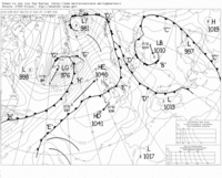
Very often one or more frontal systems cross Europe and it is this process which dominates the local weather.

Try to pinpoint the centre of the low-pressure area and the accompanying frontal system with the warm front and the cold front.
 
 
Draw the frontal systems on the printout. Remember that the fronts divide cold and warm air masses.

How do the fronts correspond to the weather boundaries you drew earlier?

Compare the wind pattern and the temperatures around the frontal system.

Compare your interpretation with a weather map.


Current weather map from 0.00 UTC

Choose 'Bodenanalyse' to see the latest Surface map.

The weather map is of 00:00 the same day. Be aware that the weather systems will have moved since then.


The first live TV forecast
 
My forecast
 
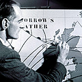
One of the reasons for observing the weather is to be able to make a weather forecast. Weather forecasts are very valuable and are used in many different ways. Today, meteorologists use all kinds of information and computer models to make the reliable weather forecasts that we see in our daily newspapers and on television.

This is a professional job! However, with a basic knowledge of meteorology and with observations made by yourself and those found on the internet, you can try to make your own.

Your class can be divided into groups to see who can make the best forecast.


Today’s weather forecast
 
 
Background for a weather forecast
 
In order to produce a weather forecast, it is important to describe the current weather situation and also the weather over the previous 24 hours or more. In addition, it is important to determine changes in the overall system, especially the frontal zones.

Current weather situation

You have already analysed the current weather using the Meteosat image with the superimposed weather observations.
 
 
Page123


Last update: 17 April 2013


Interactive Meteosat

 •  Introduction (http://www.esa.int/SPECIALS/Eduspace_Weather_EN/SEM1AAKTYRF_0.html)
 •  Weather in Europe (http://www.esa.int/SPECIALS/Eduspace_Weather_EN/SEMRBAKTYRF_0.html)
 •  Meteosat images (http://www.esa.int/SPECIALS/Eduspace_Weather_EN/SEMFDAKTYRF_0.html)
 •  Weather observations (http://www.esa.int/SPECIALS/Eduspace_Weather_EN/SEMGFAKTYRF_0.html)
 •  Wind (http://www.esa.int/SPECIALS/Eduspace_Weather_EN/SEMYHAKTYRF_0.html)
 •  Cloudiness (http://www.esa.int/SPECIALS/Eduspace_Weather_EN/SEMBKAKTYRF_0.html)
 •  Temperature (http://www.esa.int/SPECIALS/Eduspace_Weather_EN/SEM7OAKTYRF_0.html)
 •  Upload observations (http://www.esa.int/SPECIALS/Eduspace_Weather_EN/SEMYPAKTYRF_0.html)

Exercises

 •  Introduction and exercises (http://www.esa.int/SPECIALS/Eduspace_Weather_EN/SEMLQAKTYRF_0.html)

Links

 •  Eumetsat (http://www.eumetsat.int)
 •  Sarepta (http://www.sarepta.org/en/index.php)
 •  Dundee Satellite Receiving Station (http://www.sat.dundee.ac.uk/)
 •  WetterZentrale (http://www.wetterzentrale.de/)
 •  US National Hurricane Center (http://www.nhc.noaa.gov/)
 •  NOAA (http://www.noaa.gov/)
 •  Met Office (UK) (http://www.metoffice.gov.uk/)
 •  Weather map
with fronts
(choose
'Bodenanalyse')
(http://www.wetterzentrale.de/)
 •  Historical Data (http://www.eumetsat.int/Home/Main/Image_Gallery/index.htm?l=en)
 •  Cloud atlas (http://www.wolkenatlas.de/)
 •  Current weather (http://www.wetterzentrale.de/)
 •  Map of the frontal zone (http://www.wetterzentrale.de/pics/bracka.html)
 •  Map showing prognosis frontal zone (http://www.ecmwf.int/products/forecasts/d/charts)

Eduspace - Download

 •  Images and observations archive (http://www.eduspace.esa.int/eduspace/meteosat/viewArchive.asp)
 •  Download latest Meteosat animation (http://www.eumetsat.int/Home/Main/Image_Gallery/Real_Time_Imagery/index.htm?I=en)