Search and order online
MTG Lightning Imager animations - July 2023:
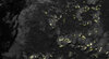
West camera – full field of view
The clip you see playing above is a web quality MP4. You may acquire the broadcast quality version(s) of this clip listed below. You may wish to check out the encoding settings of the available broadcast quality version(s) first.
Listed below are the available broadcast quality version(s) of this clip (so not including the web quality MP4 playing above). You may:
- Video file technical details: mp4
- ESA Video for professionals – Conditions of use
Quick clip selection:
-
00:02:04
-
00:01:16
-
00:01:40
-
00:01:13
-
00:02:04
-
00:01:16
-
00:00:37
-
00:00:33
-
00:02:04
-
00:01:16
 Now Playing
Details
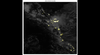
- Title MTG Lightning Imager animations - July 2023 - West camera – full field of view
- Length 00:01:16
- Footage Type Animation
- Additional Formats:
- Copyright EUMETSAT/ESA
- Use Restriction ,
- Description
The Lightning Imager’s west camera has a field of view covering the Atlantic Ocean, a small part of Africa and part of South America. This animation shows the Intertropical Convergence Zone, where clusters of tropical thunderstorms are slowly moving from the east (bottom right corner of the video) to the west (top right corner of the video).
If the waters are warm enough from June to November, some of the larger storm clusters can develop into hurricanes affecting the Caribbean and the east coast of the United States. It is also clear from the animation that most of the lightning occurs over land and during the local afternoon and evening hours.
Sun glint – reflection of the Sun from the ocean and smaller bodies of water on the land – can be seen crossing the upper part of the field of view during the afternoon. The animation was made using five days’ worth of data from the Meteosat Third GenerationLightning Imager’s west camera, from 00:00 UTC 2 June to 23:59 UTC 6 June 2023. It was made from raw preliminary data and is not for operational use.
Details
ESA TV NOTIFICATIONS

ALL TRANSMISSIONS
VIDEO DISTRIBUTION
