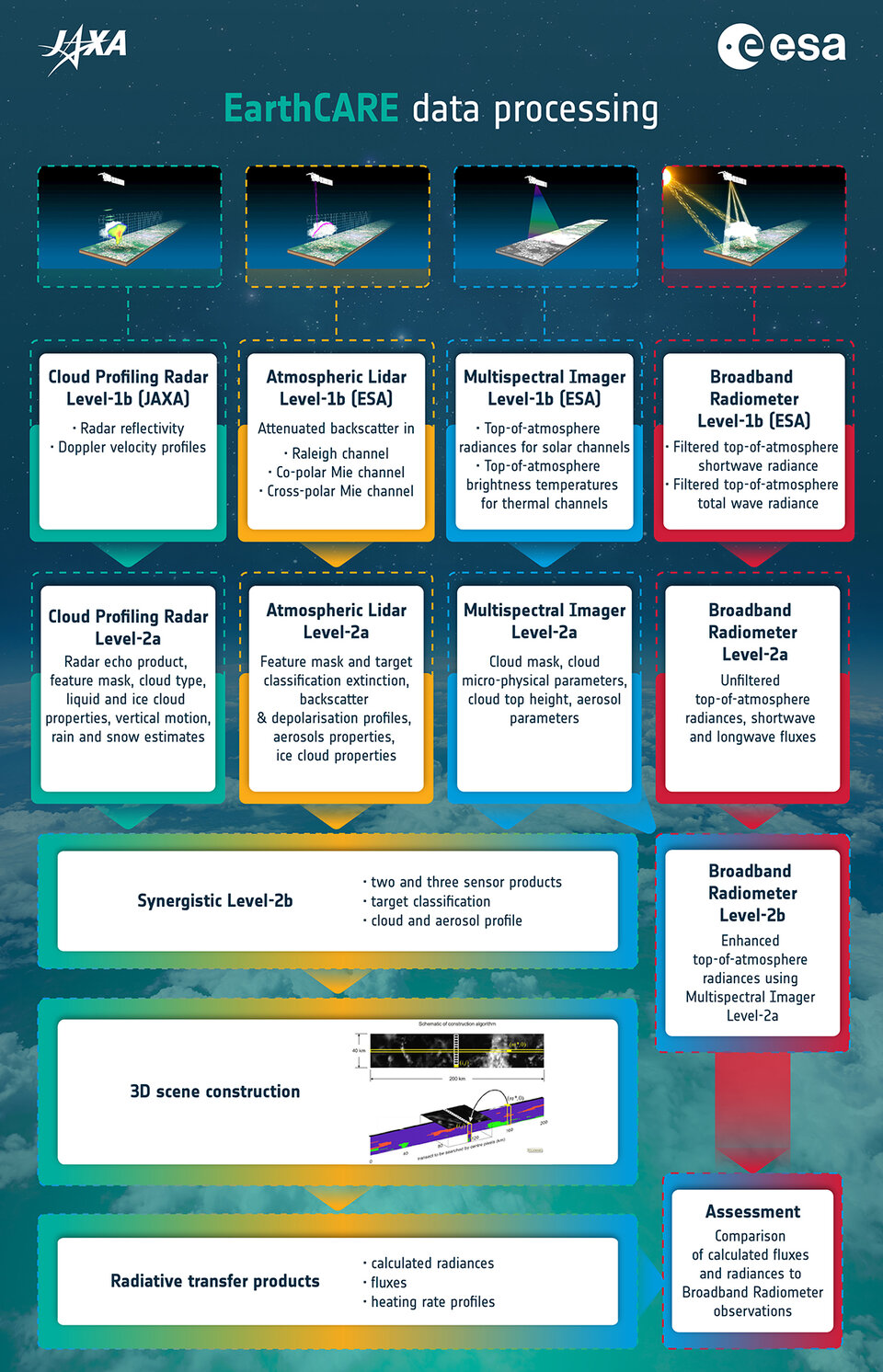
EarthCARE data products
Calibrated Level-1b data from the Atmospheric Lidar, the Multispectral Imager and the Broadband Radiometer are produced by ESA. Level-1b data from the Cloud Profiling Radar are produced by JAXA.
Both ESA and JAXA produce and exchange Level-2 data products for dissemination to each Agency’s user community.
The list below notes the foreseen Level-1b products:
-
Atmospheric Lidar
Attenuated backscatter signals in three channels: Rayleigh channel, Co-polar Mie, Cross-polar Mie -
Cloud Profiling Radar
Radar reflectivity and Doppler profiles -
Multispectral Imager
Top-of-the-atmosphere radiances for four solar channels, top of the atmosphere brightness temperatures for three thermal channels -
Broadband Radiometer
Top-of-the-atmosphere longwave and total-wave radiances
Level-2 data products are geophysical products retrieved from Level-1b data plus auxiliary data, such as meteorological data (source: European Centre for Medium-Range Weather Forecasts).
Level-2 data products include:
- Vertical profiles of cloud ice and liquid water content and effective particle and droplet size, cloud top and base heights, including multilayer clouds, fractional cloud cover and overlap
- Vertical profiles of aerosol extinction and boundary layer heights and aerosol type
- Synergistically retrieved 3D cloud and aerosol scenes
- Observed top-of-the-atmosphere broadband radiation and radiative properties (top-of-the-atmosphere and surface fluxes and vertical heating profiles) estimated from the retrieved cloud and aerosol fields
One EarthCARE’s strengths, is that the data products are derived by exploiting the synergy between the four instruments.
The Level-2 data products fall into two groups:
- Level-2a data products are geophysical parameters retrieved from any one single instrument
- Level-2b data products are geophysical parameters retrieved from the synergistic exploitation of two or more instruments, ‘synergistic products’
The following lists show the Level-2a and Level-2b data products jointly developed by ESA and JAXA. The details of the data products and the theoretical basis of their retrieval algorithms will be made available in due course.
Atmospheric Lidar Level-2a
- feature mask and target classification
- extinction, backscatter and depolarisation profiles
- aerosol properties
- ice cloud properties
Cloud Profiling Radar Level-2a
- radar echo product
- feature mask, cloud type, liquid and ice cloud properties
- vertical motion
- rain and snow estimates
Multispectral Instrument Level-2a
- cloud mask
- cloud microphysical parameters
- cloud top height
- aerosol parameters
Broadband Radiometer Level-2a
- unfiltered radiances
- shortwave and longwave fluxes
Level-2b synergistically derived cloud and aerosol products using combinations of Atmospheric Radar and/or Cloud Profiling Radar and/or Multispectral Imager data
- target classification**
- cloud and precipitation best estimates**
- vertical motion within clouds**
- cloud top height*
- cloud fraction, overlap and averaged microphysics**
- aerosol column descriptor*
- 3D cloud and aerosol scenes***
*1D value from combination of Atmospheric Lidar and Multispectral Imager data
**2D profiles along satellite ground track
***full 3D scenes derived from the 2D parameters** in combination with Multispectral Imager across-track information
Level-2b synergistic radiation products
- Broadband unfiltered radiances improved by inclusion of Multispectral Imager data
- Top-of-the-atmosphere fluxes from the Broadband Radiometer improved by including Multispectral Imager data
- Radiative properties (including top-of-the-atmosphere radiances and fluxes) calculated from Level-2b product 3D cloud and aerosol scenes using 1D and 3D radiative transfer models