Seville, Spain
Ahead of next week’s ‘Space19+’ Ministerial Council, the Copernicus Sentinel-2 mission takes us over Seville in southern Spain – the destination for this milestone event.
On 27–28 November, Ministers from ESA’s Member States along with Associate Member Slovenia and Cooperating State Canada will meet in Seville for the ESA Council at Ministerial Level Space19+ to discuss future space activities for Europe and the budget of Europe’s space agency for the coming three years. Space19+ is an opportunity to direct Europe’s ‘next generation’ ambitions in space, and address the challenges facing not only the European space sector, but also European society as a whole.
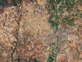
Seville, visible towards the top right of this image, is the capital of Andalusia and the fourth largest city in Spain. An inland port, it lies on the Guadalquivir River and while the original course of the river is visible snaking through the city on the right, we can see where water has also been redirected into a straighter course on the left. At over 650 km long, the Guadalquivir is one of the longest rivers in Spain, extending way beyond the frame of this image. Nevertheless, it can be seen winding its course all the way from the top right of the image, just south of the Sierra Norte mountain range, to the Gulf of Cádiz where it empties into the Atlantic Ocean. On route, this major river serves as a source for irrigation – here noticeable in the top right of the image, but mainly to the south of Seville where large green agricultural fields appear in sharp contrast to the surrounding drier brown land.
The Doñana National Park lies on the right bank of the Guadalquivir River, at its estuary on the Atlantic Ocean. One of Europe's most important wetland reserves, the park is an area of marsh, shallow streams and sand dunes, and an important site for endangered and migrating birds.
Copernicus Sentinel-2 is a two-satellite mission. Each satellite carries a high-resolution camera that images Earth’s surface in 13 spectral bands. Data from Copernicus Sentinel-2 are used to monitor changes in land cover, agriculture, and coastal and inland waters.
This image, captured on 21 June 2019, is also featured on the Earth from Space video programme.