• → European Space Agency

      • Space for Europe
      • Space News
      • Space in Images
      • Space in Videos
    • About Us

      • Welcome to ESA
      • DG's News and Views
      • For Member State Delegations
      • Business with ESA
      • ESA Exhibitions
      • ESA Publications
      • Careers at ESA
    • Our Activities

      • Space News
      • Observing the Earth
      • Human Spaceflight
      • Launchers
      • Navigation
      • Space Science
      • Space Engineering
      • Operations
      • Technology
      • Telecommunications & Integrated Applications
    • For Public

    • For Media

      • Media
      • ESA TV
      • Videos for professionals
      • Photos
    • For Educators

    • For Kids

    • ESA

    • Observing the Earth

    • Understanding Our Planet

    • Securing Our Environment

    • Benefiting Our Economy

    • About Observing the Earth

      • How does Earth Observation work?
      • How to get Earth observation data
      • Integrating Earth Observation in your job
      • Earth Observation users speak
    • EO programmes
    • The Living Planet
    • GMES
    • ESA's Earth Observing missions
    • Envisat overview
    • ERS overview
    • Earth Explorers overview
    • Sentinels overview
    • MSG overview
    • MetOp overview
    • Proba-1 overview
    • Third Party Missions overview
    • Opportunities with us

      • Education & training
      • International cooperation
      • Milestones & announcements
    • Multimedia

      • Image Gallery
      • Video Gallery
      • Online resources
      • RSS feeds
    • Services
    • Subscribe

    ESA > Our Activities > Observing the Earth

    Korean satellite to aid disaster efforts

    Yucatan Peninsula, Mexico
    Kompsat-2 image
    15 July 2011

    South Korea’s space agency has joined its international counterparts in putting satellite data at the disposal of rescue authorities following major disasters such as earthquakes and tsunamis.

    The Korea Aerospace Research Institute (KARI), under the Ministry of Education, Science and Technology, formally became the newest member of the International Charter ‘Space and Major Disasters’ on 7 July.

    Founded by ESA and the French space agency, CNES, the Charter is an international collaboration between the owners and operators of Earth observation missions to provide rapid access to satellite data to help disaster management authorities in the event of a natural or man-made disaster.

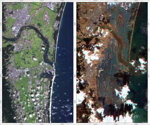
    Through the Charter, satellite data were used to create maps and aid rescue efforts following recent disasters such as the January 2010 earthquake in Haiti, the February 2011 earthquake in New Zealand and the March 2011 earthquake and tsunami in Japan.

    “The Charter in an excellent example of international cooperation in the field of natural disasters, as it has recently been demonstrated in connection with the tsunami in Japan and severe snow in the east coast of Korea,” said Dr Yougsik Chun, Director of Satellite Operations & Applications Division, after the signing ceremony.


    Signing ceremony

    As the Charter’s newest member, KARI will contribute free images from its Kompsat-2 satellite.

    Launched in 2006, Kompsat-2 is equipped with a multispectral camera able to acquire 1 m-resolution panchromatic images and 4 m-resolution colour images.

    KARI has now established a collaboration with Korea’s National Institute for Disaster Protection (NIDP) under the National Emergency Management Agency to respond to disasters based on satellite information.

    Dr Seung Jo Kim, KARI President, noted, “We are proud to have KARI join its space partners in supporting the disaster charter, particularly since the charter has recently illustrated the relevance of space in alleviating human suffering caused by natural and technological disasters.”

    Rate this

    Views

    Share

    • Currently 0 out of 5 Stars.
    • 1
    • 2
    • 3
    • 4
    • 5
    Rating: 0/5 (0 votes cast)

    Thank you for rating!

    You have already rated this page, you can only rate it once!

    Your rating has been changed, thanks for rating!

    49
    Tweet
    • Related news
      • Mapping Japan's changed landscape from space
        • 10th Anniversary of the International Charter "Space and Major Disasters"
          • Charter ‘chat’
            • Envisat monitoring changes in oil spill
              • First satellite map of Haiti earthquake
              • In depth
              • The International Charter Space and Major Disasters
              • Kompsat-2
              • Related links
              • Korea Aerospace Research Institute
              • CNES

    Connect with us

    • RSS
    • Youtube
    • Twitter
    • Flickr
    • G+
    • Facebook
    • Livestream
    • Subscribe
    • App Store
    • LATEST ARTICLES
    • · Rare merger reveals secrets of gal…
    • · Watching for hazards: ESA opens as…
    • · ESA astronaut Timothy Peake set fo…
    • · Space drives e-mobility
    • · Proba-V opens its eyes
    • FAQ

    • Jobs at ESA

    • Site Map

    • Contacts

    • Terms and conditions