• → European Space Agency

      • Space for Europe
      • Space News
      • Space in Images
      • Space in Videos
    • About Us

      • Welcome to ESA
      • DG's News and Views
      • For Member State Delegations
      • Business with ESA
      • ESA Exhibitions
      • ESA Publications
      • Careers at ESA
    • Our Activities

      • Space News
      • Observing the Earth
      • Human Spaceflight
      • Launchers
      • Navigation
      • Space Science
      • Space Engineering
      • Operations
      • Technology
      • Telecommunications & Integrated Applications
    • For Public

    • For Media

      • Media
      • ESA TV
      • Videos for professionals
      • Photos
    • For Educators

    • For Kids

    • ESA

    • Observing the Earth

    • Understanding Our Planet

    • Securing Our Environment

    • Benefiting Our Economy

    • About Observing the Earth

      • How does Earth Observation work?
      • How to get Earth observation data
      • Integrating Earth Observation in your job
      • Earth Observation users speak
    • EO programmes
    • The Living Planet
    • GMES
    • ESA's Earth Observing missions
    • Envisat overview
    • ERS overview
    • Earth Explorers overview
    • Sentinels overview
    • MSG overview
    • MetOp overview
    • Proba-1 overview
    • Third Party Missions overview
    • Opportunities with us

      • Education & training
      • International cooperation
      • Milestones & announcements
    • Multimedia

      • Image Gallery
      • Video Gallery
      • Online resources
      • RSS feeds
    • Services
    • Subscribe

    ESA > Our Activities > Observing the Earth

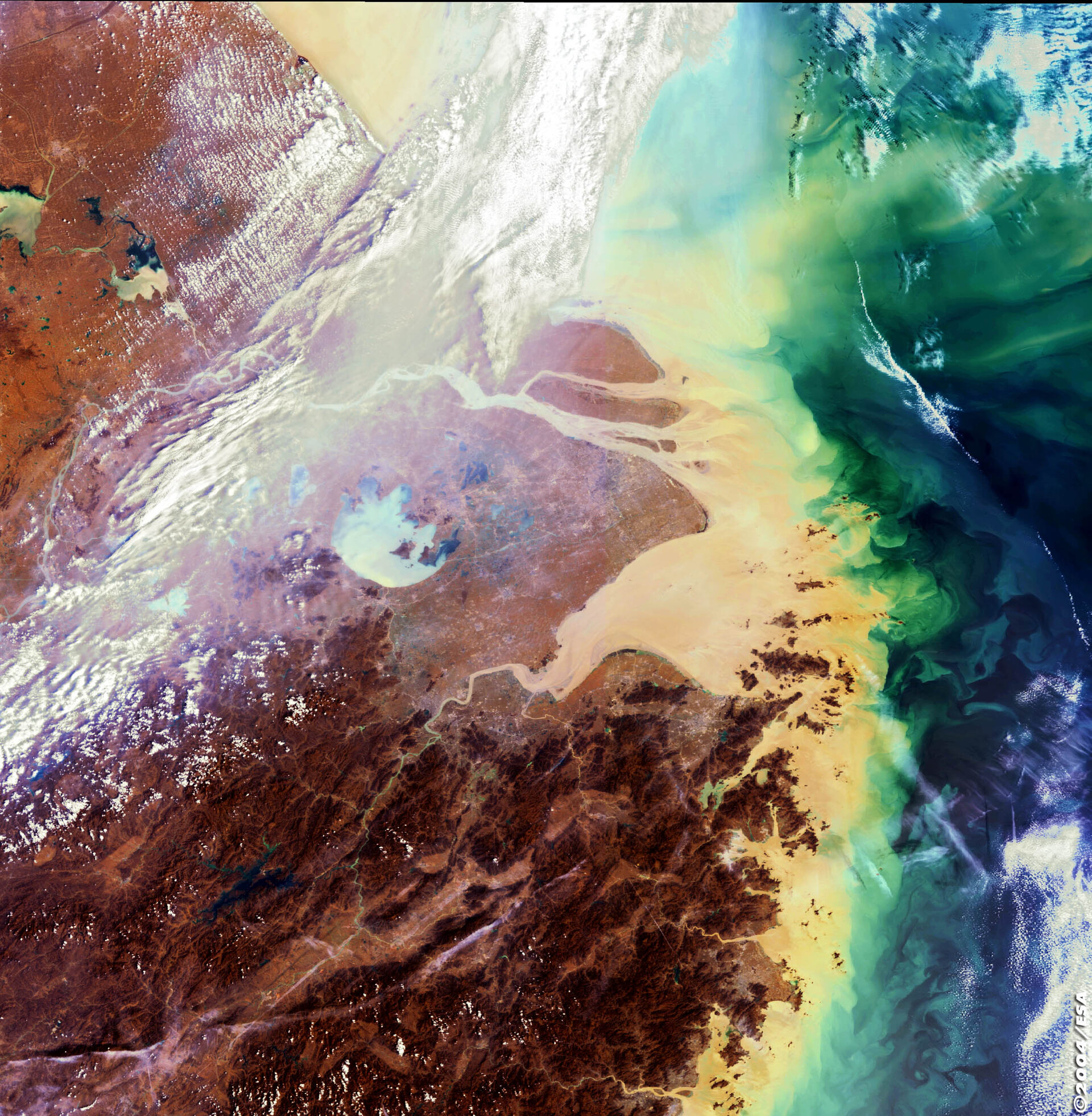
    Mouth of the mighty Yangtze

    Shanghai, China - MERIS - 21 March 2003
    25 March 2004

    The coloured waters shown here in this 21 March Envisat Medium Resolution Imaging Spectrometer (MERIS) image have concluded a long journey across China.

    They are surging into the East China Sea from the mouth of the Yangtze River, which at 6300 km long is the longest river in Asia and the third longest in the world.

    Rising in the Qinghai-Tibetan Plateau, the Yangtze River snakes through nine provinces and serves as a drain for 1.8 million square kilometres of territory. MERIS is designed to detect ocean colour, and clearly visible here is how the Yangtze's heavy sediment plume discharges into and colours the waters along the Chinese coast. Its total sediment load is estimated at 680 million tonnes a year – equivalent in weight to a hundred Great Pyramids.

    Shanghai - China's largest city - is located south of the Yangtze mouth and the 1000-km-long navigable stretch of the Yangtze west of it is a zone of major economic activity. The downside of recent growth has been a decrease in water quality that the Chinese government say it intends to combat. At the start of the month an accidental chemical spill into a tributary of the Yangtze temporarily deprived almost a million people of drinking water.

    Rate this

    Views

    Share

    • Currently 0 out of 5 Stars.
    • 1
    • 2
    • 3
    • 4
    • 5
    Rating: 0/5 (0 votes cast)

    Thank you for rating!

    You have already rated this page, you can only rate it once!

    Your rating has been changed, thanks for rating!

    117
    Tweet
    • Related articles
      • China’s Three Gorges Dam
        • Envisat MERIS image of the world March 2003
        • Related links
        • Envisat Mission
        • Envisat results
        • Envisat instruments

    Connect with us

    • RSS
    • Youtube
    • Twitter
    • Flickr
    • G+
    • Facebook
    • Livestream
    • Subscribe
    • App Store
    • LATEST ARTICLES
    • · Rare merger reveals secrets of gal…
    • · Watching for hazards: ESA opens as…
    • · ESA astronaut Timothy Peake set fo…
    • · Space drives e-mobility
    • · Proba-V opens its eyes
    • FAQ

    • Jobs at ESA

    • Site Map

    • Contacts

    • Terms and conditions