• → European Space Agency

      • Space for Europe
      • Space News
      • Space in Images
      • Space in Videos
    • About Us

      • Welcome to ESA
      • DG's News and Views
      • For Member State Delegations
      • Business with ESA
      • ESA Exhibitions
      • ESA Publications
      • Careers at ESA
    • Our Activities

      • Space News
      • Observing the Earth
      • Human Spaceflight
      • Launchers
      • Navigation
      • Space Science
      • Space Engineering
      • Operations
      • Technology
      • Telecommunications & Integrated Applications
    • For Public

    • For Media

      • Media
      • ESA TV
      • Videos for professionals
      • Photos
    • For Educators

    • For Kids

    • ESA

    • Space Science

    • Our Universe
    • About Space Science
    • ESA's 'Cosmic Vision'
    • Science missions
    • Mission navigator
    • Target groups
    • For Media
    • For Scientists
    • For Kids
    • Multimedia
    • Science images
    • Science videos
    • Animations
    • Downloads
    • Sounds from space
    • Resources
    • Reference section
    • Services
    • FAQs
    • Glossary
    • Help
    • Portal terms of use
    • Comments
    • Follow us
    • RSS feeds
    • ESA Sci on Twitter
    • ESA Space Science Images on Flickr
    • ESA 3D on Flickr

    ESA > Our Activities > Space Science

    Southeast of Amenthes Planum

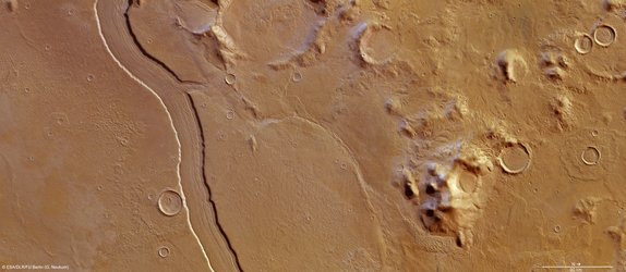
    At the mouth of the red valley

    14 February 2013

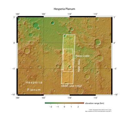
    ESA’s Mars Express took a high-resolution stereo image on 13 January of the southeast corner of the Amenthes Planum region on Mars, near to Palos crater and the mouth of a well-known sinuous valley, Tinto Vallis.

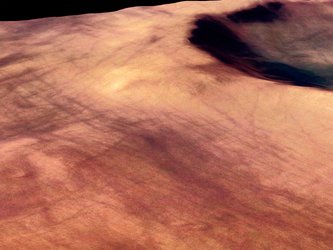
    At the bottom-centre of the full-colour image above, and up close in the first perspective image, is a nearby shorter and wider valley, which is fed by a number of tributaries before it joins the mouth of Tinto Vallis as both empty into Palos crater, just off the bottom of the image.

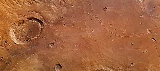
    The 190 km-long Tinto Vallis is seen in the context image and is named after the famous Rio Tinto river in the Andalucía region of Spain. It is believed to have formed around 3.7 billion years ago, during the early history of Mars.

    Valley feeding Palos Crater

    The network of shorter valleys shown in the first perspective image is thought to have formed through volcanic activity melting subsurface ice and liberating water to the martian surface via seeps and springs.

    If underground water emerges to the surface from the side of a slope – a process that planetary geologists call ‘groundwater sapping’ – it weakens the ground above it, causing it to collapse. Over time, this process may lead to the formation of steep-sided U-shaped valleys.

    Groundwater sapping is believed to be responsible for erosion seen in many of the valley networks on the Red Planet.

    Amenthes Planum in context

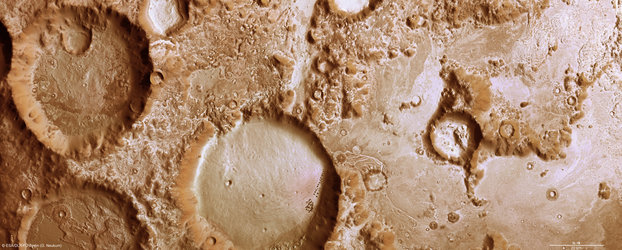
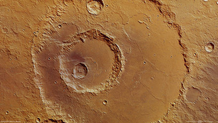
    Another eye-catching feature is the relatively deep 35 km-wide crater seen in the left-hand portion of the colour, topographic and 3D images. Spectacular landslides along the crater’s walls can be seen and are particularly evident along the broken southern (left) rim.

    This crater sits on top of at least three older craters, the largest of which is 100 km wide and dominates the whole top left half of the 2D and 3D anaglyph images. The western rim of this crater continues beyond the image frame, and can be more easily distinguished in the context image.

    Amenthes Planum topography

    The floor of this 100 km-wide crater is chaotic, with flat-topped geological features called mesas, and their smaller siblings, buttes, littering the floor. These are probably the result of the removal of subsurface water ice leading to the collapse of weaker material around them, leaving these more resistant high-sided features behind.

    On Earth, the desert regions in Utah are home to many examples of these types of formation.

    Trough feeding Amenthes Planum

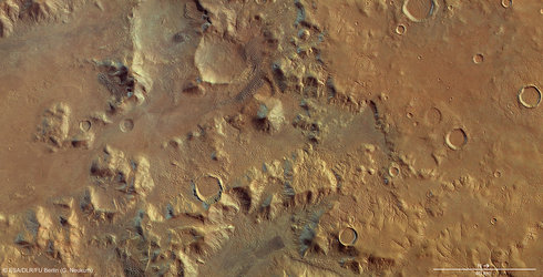
    Toward the north (right) side of the 2D images, several smaller craters display very smooth and flat floors, from infilling by sediments.

    The darker regions to the far north and south shown most clearly in the first colour image are covered in wind-transported basaltic sands.

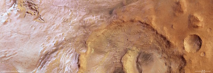
    The smooth low-lying region to the far right and shown in the second perspective image is a small trough that feeds into the broader lava field of Amenthes Planum. The trough has likely been modified by the outflow of material from the ancient lake that may have once existed in Palos crater, the rim of which can only just be seen at the bottom of the colour, topographic and 3D images.

    This smooth, channel-like feature brushes against the rim of a 30 km-wide crater, and both have been covered with dark wind-blown materials.

    Amenthes Planum in 3D

    With these recent images, Mars Express continues to show the similarities between regions on Mars with those on our home planet.

    Rate this

    Views

    Share

    • Currently 5 out of 5 Stars.
    • 1
    • 2
    • 3
    • 4
    • 5
    Rating: 4.87/5 (74 votes cast)

    Thank you for rating!

    You have already rated this page, you can only rate it once!

    Your rating has been changed, thanks for rating!

    11304
    Tweet

    Related articles

    Reull Vallis: a river ran through it17 January 2013

    Reull Vallis: a river ran through it17 January 2013 ESA’s Mars Express imaged the striking upper part of the Reull Vallis region of Mars with its high-resolution stereo camera last year.

    Charitum Montes: a cratered winter wonderland06 December 2012

    Charitum Montes: a cratered winter wonderland06 December 2012 The high-resolution stereo camera on ESA’s Mars Express imaged the Charitum Montes region of the Red Planet on 18 June, near to Gale crater and the Argyre basin featured in our October and November image releases.

    NereidumMontes

    Nereidum Montes helps unlock Mars’ glacial past01 November 2012

    NereidumMontes

    Nereidum Montes helps unlock Mars’ glacial past01 November 2012 On 6 June, the high-resolution stereo camera on ESA’s Mars Express revisited the Argyre basin as featured in our October release, but this time aiming at Nereidum Montes, some 380 km northeast of Hooke crater.

    Argyre Planitia and Hooke Crater

    Ice-coated beauty in Mars’ Silver Island04 October 2012

    Argyre Planitia and Hooke Crater

    Ice-coated beauty in Mars’ Silver Island04 October 2012 On 8 June, the high-resolution stereo camera on Mars Express captured a region within the 1800 km-wide and 5 km-deep Argyre basin, which was created by a gigantic impact in the planet’s early history.

    Hadley Crater provides deep insight into martian geology06 September 2012

    Hadley Crater provides deep insight into martian geology06 September 2012 Recently engaged in providing support to the successful landing of NASA’s Mars Science Laboratory's Curiosity rover, ESA’s Mars Express has now returned to its primary mission of studying the diverse geology and atmosphere of the 'Red Planet' from orb...

    The fractured features of Ladon basin02 August 2012

    The fractured features of Ladon basin02 August 2012 ESA’s Mars Express has observed the southern part of a partially buried approx. 440-km wide crater, informally named Ladon basin.

    Martian crater and dust devil tracks

    Promethei Terra, southern highlands of Mars12 October 2004

    Martian crater and dust devil tracks

    Promethei Terra, southern highlands of Mars12 October 2004 These images, taken by the High Resolution Stereo Camera (HRSC) on board ESA’s Mars Express spacecraft, show a part of the southern highlands of Mars, called Promethei Terra.

    • Looking at Mars
    • Phobos up close
      Phobos up close
      Mars Express blog
    • See the Mars Webcam from ESA's Spacecraft Operations team
      See the Mars Webcam from ESA's Spacecraft Operations team
      Mars Webcam
    • More about...
      • Mars Express overview
      • Related links
      • High Resolution Stereo Camera
        • Behind the lens...
          • Frequently asked questions
          • ESA Planetary Science archive (PSA)
          • NASA Planetary Data System
          • HRSC data viewer
          • In depth
          • Mars Express in depth

    Connect with us

    • RSS
    • Youtube
    • Twitter
    • Flickr
    • G+
    • Facebook
    • Livestream
    • Subscribe
    • App Store
    • ESA Science Twitter

    Follow ESA science

    • LATEST ARTICLES
    • · Rare merger reveals secrets of gal…
    • · Watching for hazards: ESA opens as…
    • · ESA astronaut Timothy Peake set fo…
    • · Space drives e-mobility
    • · Proba-V opens its eyes
    • FAQ

    • Jobs at ESA

    • Site Map

    • Contacts

    • Terms and conditions