| | | | |
 |
|
About Eduspace What is Eduspace?What tools does it offer? Choose your language Remote Sensing Principles What is remote sensing?Remote sensing in depthHistory of Earth observationMapping and satellite dataSatellite orbitsEarth observation satellites Resources Multimedia Image GalleryVideo GalleryServices Contact usSearch in Eduspace
| | | | | | | Eduspace Image Catalogue
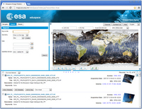
Satellite imagery from different regions of the electromagnetic spectrum including infrared, active microwave and visible, can be downloaded from the Eduspace image catalogue. The catalogue has a user-friendly interface that allows users to search by geographic region, date and satellite sensor. The imagery that can be obtained through the catalogue has been acquired by the following sensors from ESA-supported satellite missions:
- Envisat MERIS
- Envisat ASAR
- ERS SAR
- Landsat TM
- Landsat ETM
You can access the Eduspace Image Catalogue application by clicking on the link on the right. A tutorial, which provides a quick-start guide to using the catalogue, is also available.
| |
| | Eduspace Image Catalogue Viewer Eduspace Image CatalogueEduspace Image Catalogue Viewer Tutorial
|