ESA
Education
Hjem
Vejr og klima
Globale forandringer
Naturkatastrofer
Forandring af kystlinien
Donau-deltaet
Olieforurening fra borerig
Skovrydning
Bardia National Park
Congobækkenet
Kameng-Sonitpur Elephant Reserve
Kilimanjaro
Rondonia
Shillong og Guwahati
Is
Antarktis 2003
Klimaforandringer og gletsjere
Gletscheres tilbagesmeltning i Alperne
Gletsjerisens bevægelse
Gletsjeranalyse ved hjælp af radarbilleder
Monitorering af gletschere i Himalaya
Telemåling af is og sne
Urbanisering
Cairo
Cordoba
Kathmandu
Himalaya
Kathmandudalen
Lagos
Vegetation
Annapurna Conservation Area
Forsvundet i Andesbjergene
Ngorongoro Conservation Area
Niger-indlandsdeltaet
Sydamerika
Søg
Article Images
Baggrund
Tilbage til artiklen
Download:
HI-RES GIF
(Size:
729 kb
)
Landsat satellite images showing retreating glaciers in the Andes of Peru, South America. (See GoogleEarth file location 3.8)
Credits: Landsat
Tilbage til artiklen
Download:
HI-RES GIF
(Size:
129 kb
)
Model of a glacier with accumulation area, ablation area, terminal lake and moraine. To learn more about the dynamics of glaciers, go to our Glacier Ice Flow case study.
Tilbage til artiklen
Download:
HI-RES JPEG
(Size:
30 kb
)
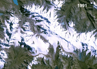
Credits: Andreas Kääb
Tilbage til artiklen
Download:
HI-RES JPEG
(Size:
29 kb
)
Credits: Andreas Kääb
Klimaforandringer og gletsjere
Indledning
Øvelser
Introduktion til arbejdsarket
Øvelse 1: Inspektion af ægte RGB-farvebilleder
Øvelse 2: Animation
Øvelse 3: Båndaritmetik
Øvelse 4: GIS
Øvelse 5: Måling af areal
Øvelse 6: Multitemporal analyse
Konklusioner
Eduspace - Software
LEOWorks 4 (MacOS)
LEOWorks 4 (Linux)
LEOWorks 4 (Windows)
Eduspace - Download
Andes_images.zip
GoogleEarth file
Copyright 2000 - 2015 © European Space Agency. All rights reserved.


 in the very east of the Berne canton in")
 in Switzerland")