| | | | |
 |
|
Coastal change Danube Delta change detectionOil spillsDeforestation Bardia National ParkCongo River BasinKameng-Sonitpur Elephant ReserveKilimanjaroRondoniaShillong and GuwahatiIce Antarctica 2003Climate change and glaciersGlacier analysis using radar imageryGlacial retreat in the AlpsGlacier Ice FlowMonitoring of glaciers in the HimalayasRemote sensing of ice and snowUrbanisation CairoCity of KathmanduCórdobaHimalayasKathmandu ValleyLagosVegetation Annapurna Conservation AreaLost in the AndesNgorongoro Conservation AreaNiger Inland DeltaVegetation in South America
| | | | | | | Imja glacier
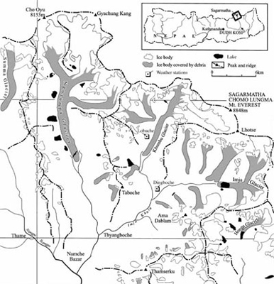
The Imja glacier and Imja Tsho
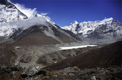
As a special focus of this study, we will analyse the development of the Imja glacier during the past 50 years. The Imja glacier is located at 27.54° N and 86.56° E in the Khumbu Himal (Look at figures 6 and 7). It originates on the western face of Kali Himal and is joined by the Lhotse Shar and Ambulapcha glaciers before it drains into the Imja Khola. The Imja Tsho is a glacial lake that appeared in the 1960’s and is still growing at the rate of about 10 m per year.
This makes it a very unstable construction, and is a threat to the inhabitants downstream the Dingboche and Imja Khola valley, which is the most densely populated Sherpa valley in Nepal. About 28 million m3 of dammed water could flood the valley in the case of a flood outburst.
Part of the Khumbu Himal with glaciers and glacial lakes
The Imja Tsho with debris moraine material
The Imja glacier and the Imja Tsho Lake were also chosen for this case study because their development has been well documented during the past 50 years. The area was first terrestrially surveyed, and maps were produced in the mid 1950’s. During the following years, a few more cartographical products were published in the same or similar way.
Additionally, with the launch of the first Earth surveying satellites in the 1960’s, optical imagery can now be used to detect changes in the glacier and the lake. Aerial photographs can also be used. With the launch of the first civilian satellites such as the Landsat Multispectral Scanner (MSS) in the 1970’s, a time-scheduled surveying instrument was born to map the Earth with 'fresh' data every 18 days. More of those instruments with higher spatial resolutions and higher repletion rates appeared during the 1980’s and 1990’s with the Landsat Thematic Mapper (TM) and Enhanced Thematic Mapper Plus (ETM+), among others.
Availability of remotely sensed data sets in the Khumbu Himal
| |
| | Monitoring of glaciers in the Himalayas IntroductionGlaciersInvestigation areaKhumbu's glaciersExercises Location of the study area, Khumbu HimalDevelopment of glacial lakes in the Khumbu HimalGlacier retreat at Honku glacierLinks Further ReadingEduspace - Software LEOWorks 3Eduspace - Download glacier_worksheet1.zipglacier_worksheet2.zipglacier_worksheet3.zip
|