
The clays of Mawrth Vallis
ESA's Mars Express has revisited an old favourite: the distinctive and fascinating Mawrth Vallis, one of the most promising locations on Mars in our search for signs of life.
Mars Express has imaged this area of the Red Planet before. Data collected by the spacecraft were used to create a large mosaic of Mawrth Vallis back in 2016, alongside an associated animation of the region. Like this new image, these used observations from Mars Express’ High Resolution Stereo Camera (HRSC).
Imaging the same part of the planet at different times is important to not only improve our models and mosaics of Mars but also to hunt for any changes across the planet’s surface, seasonal or otherwise, and to correct for the effects of clouds or dust in the martian atmosphere, which can complicate our mapping.
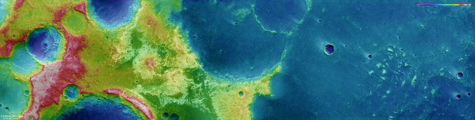
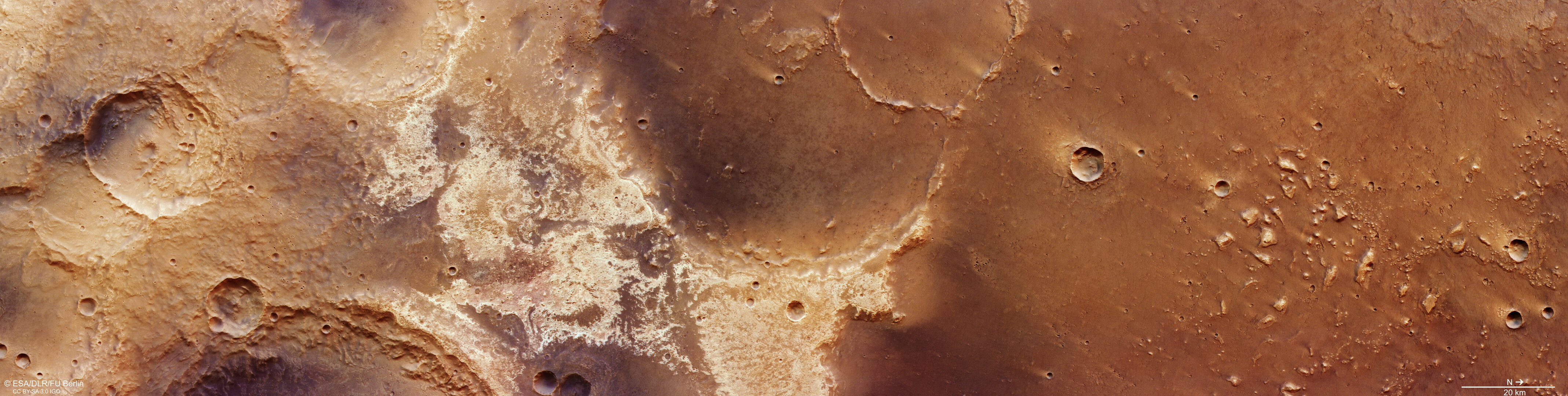
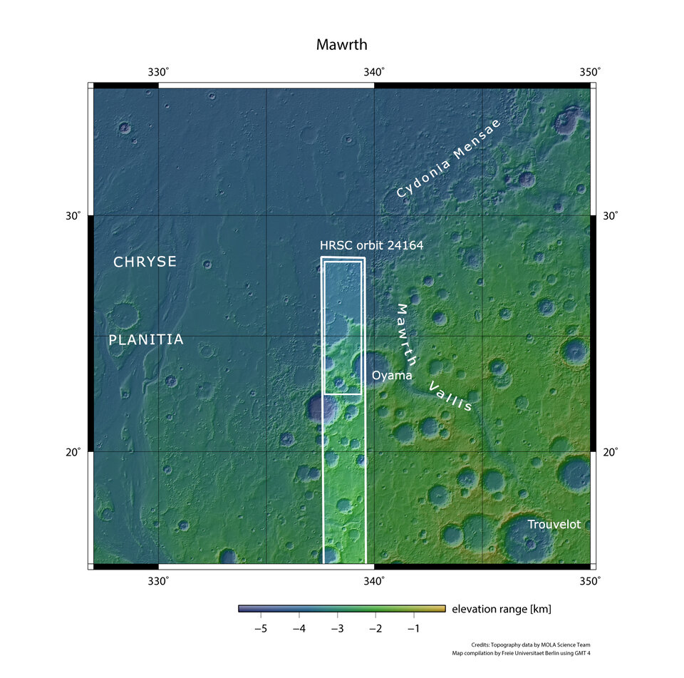
Notably, this image features the martian dichotomy boundary: a ridge that encircles Mars, marking where the southern highlands meet the northern lowlands. The two hemispheres are markedly distinct, differing in height by up to 3 km. This boundary cuts directly (and almost diagonally) through this image, and is shown most clearly in the associated topographical and context maps.
Light and dark
Mawrth Vallis is thought to be hugely promising in our hunt for life on Mars – past or present. Because of this, it was shortlisted as one of the two most promising landing sites for the ExoMars Rosalind Franklin rover. It was runner-up to Oxia Planum, which lies nearby and will provide additional insight into the history of water – and therefore potential life – across this part of Mars.
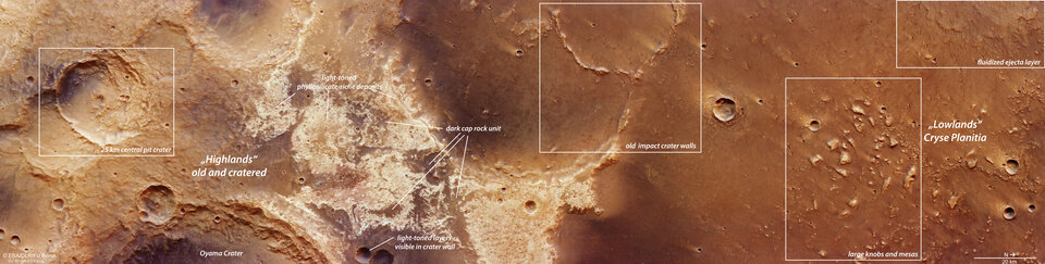
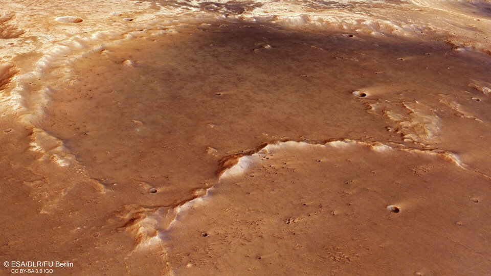
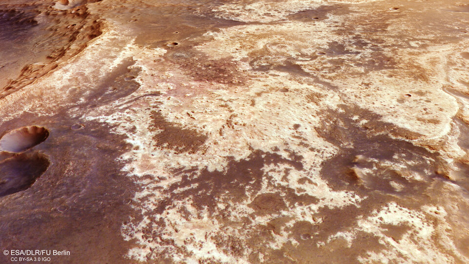
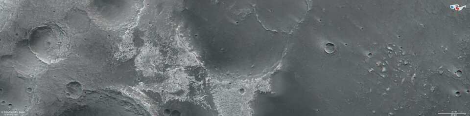
The region is thickly coated in light-toned clays containing silicate minerals; these deposits – some 200 m deep in places – are the most widespread found on Mars, and are obviously visible in these new images (and clearest in the annotated version). The light clays are overlaid by darker ‘caps’, which are thought to be of volcanic origin.
Alongside HRSC, Mars Express has employed its spectrometer (OMEGA) to identify the clay minerals seen here, finding them to be rich in iron, magnesium and aluminium. As clay minerals require water to form, they are clear evidence that water was once abundant here. In fact, we know that liquid water did once run through Mawrth Vallis around 3.6 billion years ago. Could some microbes from this time remain preserved in the rock, shielded from radiation and erosion, just waiting to be discovered by astrobiologists?
From highland to lowland
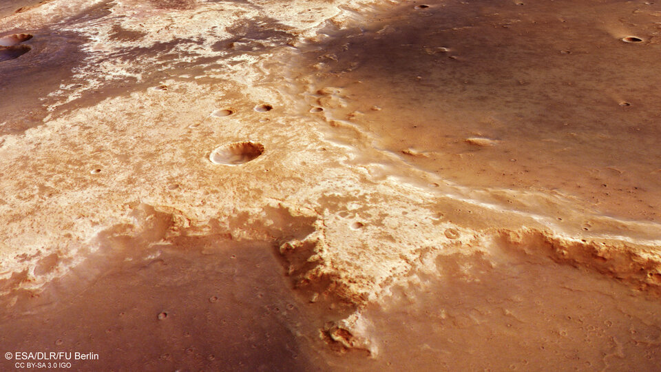
These new images display fascinating features. The ground to the left of the main image is far higher in relief than the right, as shown starkly in the associated topographic map. It is also older and more weathered, and is dominated by a large 25 km-wide impact crater with a partly collapsed wall and a smaller crater inside at its central point (a central pit). Central pits may indicate the presence of buried ice that is vaporised during the impact, causing the surface above to collapse.
To the centre of the image, right of the central pit crater, are the aforementioned large patches of light-toned clays. Clays can also be seen within the walls of some of the craters here, interspersed with caps of dark volcanic rock.
Further to the right (north), the terrain smooths out and drops in relief. This is the beginning of the martian lowlands – more precisely, a plain named Chryse Planitia. Two large, interconnected, and highly eroded craters sit on this boundary; the larger one is some 75 km across, the smaller one about 35 km across. Chryse Planitia is a fascinating part of Mars. In previous explorations, Mars Express’ MARSIS radar instrument found ancient buried basins here, stretching out for hundreds of km below ground.
Keeping these craters company is a number of ‘mesas’ and knobs (small hills) of around 3 km across, scattered across the northernmost terrain (to the right). Last but not least, to the top right of the frame lies evidence of a previous impact event. This impact released a mix of water, rock and debris that flowed like mud, creating a blanket that flooded across the surface.
Exploring Mars
Mars Express has been orbiting the Red Planet since 2003. It is imaging Mars’s surface, mapping its minerals, identifying the composition and circulation of its tenuous atmosphere, probing beneath its crust, and exploring how various phenomena interact in the martian environment.
The spacecraft’s HRSC, responsible for these images, has revealed much about Mars’s diverse surface in the past 20 years. Its images show everything from wind-sculpted ridges and grooves to sinkholes on the flanks of colossal volcanoes to impact craters, tectonic faults, river channels and ancient lava pools. The mission has been immensely productive over its lifetime, creating a far fuller and more accurate understanding of our planetary neighbour than ever before.
The Mars Express High Resolution Stereo Camera (HRSC) was developed and is operated by the German Aerospace Center (Deutsches Zentrum für Luft- und Raumfahrt; DLR).
For more on the other Mars Express instruments referred to in this article (OMEGA and MARSIS), visit: https://www.esa.int/Science_Exploration/Space_Science/Mars_Express/Mars_Express_orbiter_instruments