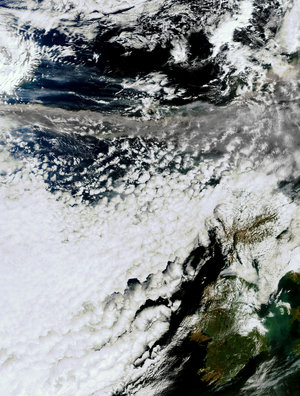
New satellite image of volcanic ash cloud
This image, acquired today by ESA's Envisat satellite, shows the vast cloud of volcanic ash sweeping across the UK from the eruption in Iceland, more than 1000 km away.
Carried by winds high up in the atmosphere, the cloud of ash from the eruption of the Eyjafjallajoekull glacier in southwest Iceland has led to the closure of airports throughout the UK and Scandinavia, with further disruption in northern Europe expected later today. The ash, which can be seen as the large grey streak in the image, is drifting from west to east at a height of about 11 km above the surface Earth. It poses a serious danger to aircraft engines; hence the airspace shut down.
The volcano erupted, for the first time since 1821, on 20 March and started erupting for a second time on Wednesday. The volcano, under the glacier ice, has caused ice melt and subsequent flooding and damage locally.
This image was acquired on 15 April 2010, at 13.25 (CEST) by Envisat's Medium Resolution Imaging Spectrometer (MERIS) while working in Full Resolution Mode to provide a spatial resolution of 300 metres.