Near-real time ozone forecasting made possible by Envisat
Stratospheric data supplied by Envisat are the basis for a near-real time global ozone forecasting service now available online.
Up in the stratosphere about 25 km above our heads is the ozone layer. Stratospheric ozone absorbs up to 98% of the Sun's harmful ultraviolet light – making the difference between a suntan and sunburn, and safeguarding all life on Earth. But chemical activity in the stratosphere ultimately due to the presence of manmade gases such as chlorofluorocarbons (CFCs) can thin the ozone layer.
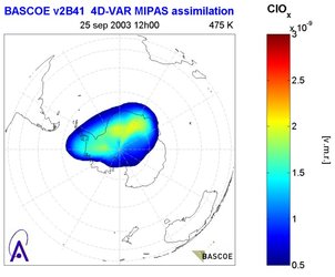
The Brussels-based Belgian Institute for Space Aeronomy (BIRA-IASB from its initials in Flemish and French) has developed a service called the Belgian Assimilation System of Chemical Observations from Envisat (BASCOE) that maps and forecasts not only the concentration of ozone in the stratosphere but also 56 other chemical species, including those responsible for ozone depletion.
BASCOE relies on an instrument aboard Envisat called the Michelson Interferometer for Passive Atmospheric Sounding (MIPAS). It works day and night to measure infrared emissions from the Earth's 'limb' – the narrow band of atmosphere between the planetary surface and empty space. Emissions along certain wavelengths work like signatures, indicating the presence of specific atmospheric chemicals.
MIPAS has the capability to measure up to 30 trace gas species, but for the time being only a subset of them is provided by the ESA ground segment operationally to the user community. The others whose concentrations are forecast by BASCOE have their presence calculated indirectly, by assimilating MIPAS level 2 products into a complex computer model of stratospheric chemistry processes developed by BIRA-IASB. The resultant analyses are available within a day.

"The stratosphere is one of the best-understood areas of atmospheric chemistry, a fact which makes the BASCOE model possible," explained Dominique Fonteyn of BIRA-IASB. "In fact this model predates the launch of Envisat, and was originally intended simply as a summary of our existing understanding of stratospheric chemistry. But the large amount of work that went into it – some 50,000 lines of code – made us look at using it in other ways, and assimilating Envisat data into it for operational use.
"The aim was to reduce the usual time delay between satellite observation and data use, in the same way weather forecasting does. As well as chemical interactions, the model also includes weather data provided by the European Centre for Medium Range Weather Forecasts, because polar stratospheric clouds transported by winds play a major role in the process of ozone destruction."
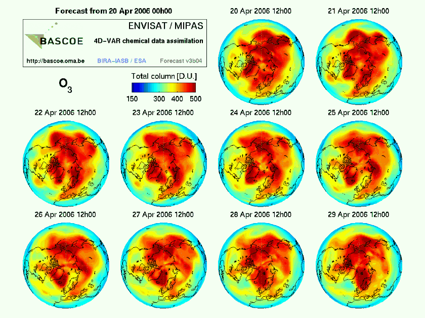
Users of the service – available at http://bascoe.oma.be - can obtain forecasts of global ozone levels for the week ahead as well as maps of nitric acid trihydrate (NAT) and active chlorine (ClOx), both implicated in ozone thinning.
The intention to use the MIPAS data to 'fine-tune' the model in future for increased accuracy, along with assimilating data from other Envisat instruments such as GOMOS (Global Ozone Monitoring by Occultation of Stars) and SCIAMACHY (Scanning Imaging Absorption Spectrometer for Atmospheric Cartography) once they become available.